October 23 logistics briefing: Colorado closures, storm risk and diesel
Friday freight planning for shippers: confirmed Colorado closures, Southwest storms, Rockies wind and snow, plus the latest weekly diesel and rail data.
By Throughline Systems · · 8 min read
What matters for your next load
- Colorado reports closures on US 160, CO 17, CO 151 and US 550. Reconfirm the actual pickup and receiving access before releasing a load.
- Friday’s forecast adds severe-storm risk in New Mexico, strong winds and mountain snow in the northern Rockies, and morning fog in Upper Michigan.
- EIA’s latest weekly U.S. diesel average remains $6.276 per gallon for October 19. AAR reports higher U.S. rail volume for the week ended October 17; neither measure is a live truck quote.
Start with access, then commit the truck
This Friday, the most immediate planning issue in the sources checked is southern Colorado access. The official road listing has multiple closures, while the weather outlook extends risk into New Mexico. A shipment can be ready at the dock and still lack a workable arrival plan.
Weather research was retrieved at 7:02 a.m. EDT on October 23, 2026; the Colorado closure list was checked at 7:08 a.m. EDT. This is a dated planning snapshot. Recheck official reports when the shipment is dispatched and again if its timing changes.
Colorado: confirmed closures, with different extents
COtrip listed the following closures in both directions at the morning check. Its safety alert attributes US 160 mileposts 157–183 and CO 17 mileposts 0–38 to flooding and adverse conditions. The individual US 550 listing also cites flooding; the other rows below say safety concerns. No reopening time is established here.
- Confirm the truck entrance and unloading area with the receiver, not only the street address.
- Ask the carrier to reassess the trip against current restrictions. A passenger-car detour may not suit the truck or freight.
- Agree who can change the delivery appointment before committing to the revised plan.
| Road and reported extent | Latest displayed update (EDT) |
|---|---|
| US 160, mileposts 157–183: east of Pagosa Springs toward South Fork | Oct 23, 6:34 a.m. |
| US 160, mileposts 133–136.8: west of Pagosa Springs | Oct 23, 1:30 a.m. |
| CO 17, mileposts 0–38: New Mexico border toward Antonito | Oct 23, 6:34 a.m. |
| CO 151, mileposts 22.8–33.6: north of Arboles | Oct 22, 10:35 p.m. |
| US 550, mileposts 75–80.2: north of Silverton | Oct 22, 8:30 p.m. |
Sources: Colorado DOT / COtrip closure list; COtrip safety closure announcement
Southwest: severe storms and localized flood risk
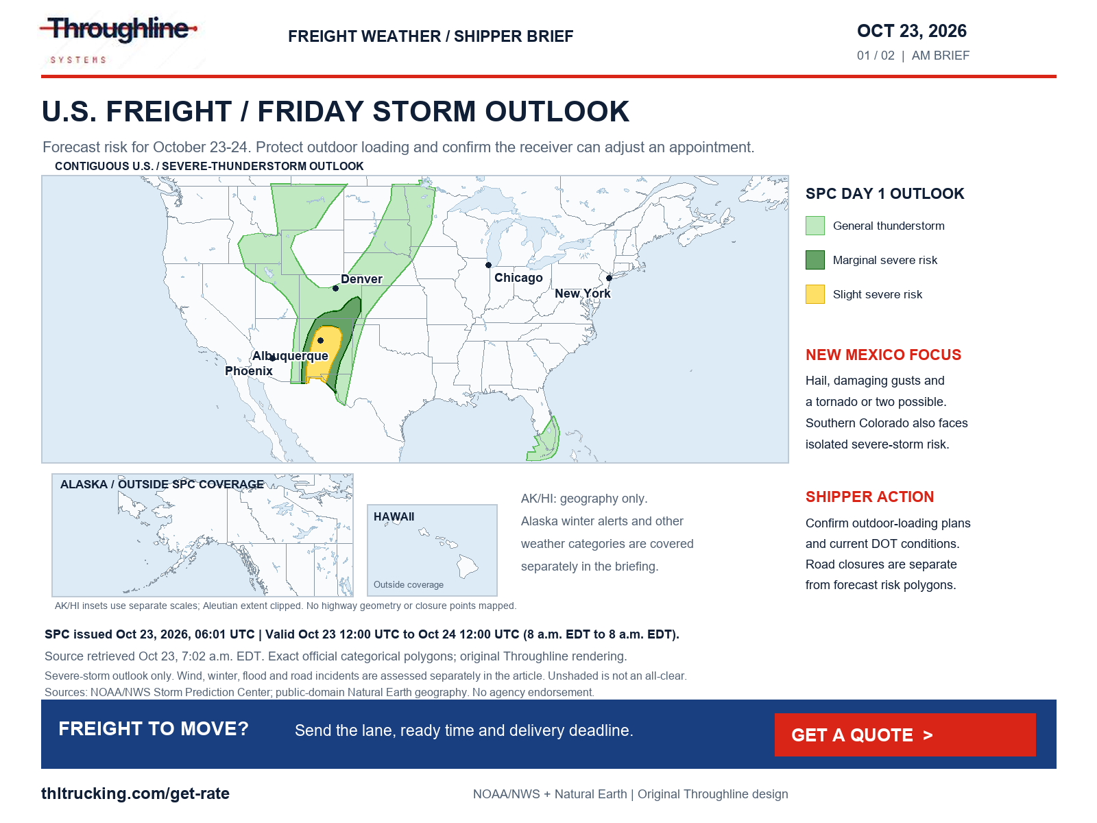
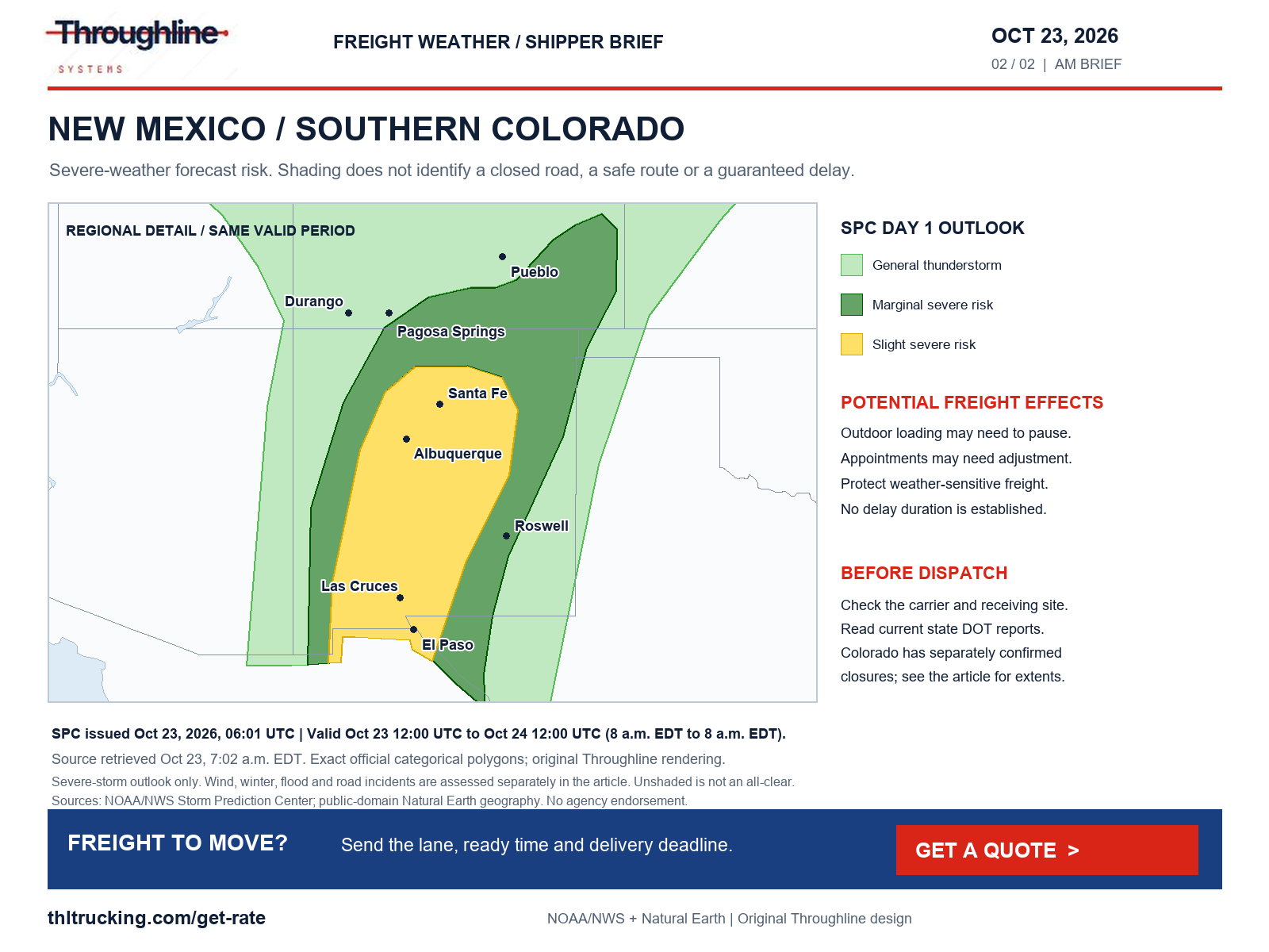
SPC’s 06:01 UTC October 23 outlook places parts of New Mexico in a Slight Risk of severe thunderstorms. The forecast discusses damaging gusts, severe hail and a tornado or two across New Mexico and southern Colorado today and tonight. The outlook is valid from 12:00 UTC October 23 to 12:00 UTC October 24: 8 a.m. EDT Friday to 8 a.m. EDT Saturday.
The maps show that severe-thunderstorm outlook only. They do not map the separate high-wind, winter, flood or transport alerts discussed below. Alaska and Hawaii are geographic insets outside this SPC product’s coverage. Select either map to open the full-size image.
WPC’s 4:04 a.m. EDT discussion separately identifies a Day 1 Slight Risk of excessive rainfall over portions of New Mexico, far western Texas and southern Colorado for the same 12:00–12:00 UTC period. This is a forecast of excessive-rainfall risk, not a statement that every road in the area is flooded. Previously wet ground and local drainage make receiver access a separate question from the regional outlook.
- For open-deck freight, confirm a loading pause plan and cargo weather protection before the truck arrives.
- For enclosed FTL or partial freight, confirm receiving access and appointment flexibility; enclosed equipment does not remove road exposure.
- For urgent production parts, tell the quote team the actual required delivery time and whether partial delivery would help. Expedite service cannot override a road closure.
Sources: NOAA/NWS SPC Day 1 outlook; NOAA/NWS WPC excessive-rainfall discussion
Wind, snow, ice and visibility need separate checks
The national NWS alert scan and WPC winter outlook identify hazards beyond the Southwest storm area. These are selected material regional findings, not a list of every alert nationwide. Warning areas and forecast amounts do not establish a truck restriction or a chain requirement.
| Hazard and geography | Issue / valid period | Potential shipper implication |
|---|---|---|
| High Wind Warning: eastern Glacier/western Toole/central Pondera, eastern Toole/Liberty and Hill County, Montana; northwest winds 35–45 mph, gusts to 65 mph | NWS issued 12:32 a.m. MDT Oct 23; valid 11 a.m.–3 p.m. MDT Oct 23 | Confirm outdoor handling plans and carrier updates; no transport restriction inferred. |
| High Wind Warning: parts of Carbon County and the North Snowy Range foothills, Wyoming; southwest winds 30–40 mph, gusts to 60 mph | NWS issued 1:20 a.m. MDT Oct 23; valid 5 a.m.–3 p.m. MDT Oct 23 | Recheck I-80 conditions and restrictions before dispatch; maintain an appointment-change contact. |
| Mountain snow: central Idaho, southwest Montana and western Wyoming; WPC highlights higher-terrain probabilities for more than 6 inches in selected areas | WPC issued 3:12 a.m. EDT Oct 23; Day 1 accumulation window 12 UTC Oct 23–12 UTC Oct 24 | Mountain forecast totals are not interstate pavement totals. Confirm the actual pass and current DOT requirements. |
| Dense Fog Advisory: central and western Upper Michigan, including Houghton, Marquette and Delta counties; visibility one-quarter mile or less | NWS issued 3:46 a.m. EDT Oct 23; through 10 a.m. EDT / 9 a.m. CDT Oct 23 | Reconfirm morning pickup and arrival expectations if visibility affects the trip. |
| Blowing dust: Powder River Basin, northeastern Wyoming; an Air Quality Alert describes strong winds and blowing dust | NWS/ Wyoming DEQ message issued 8:38 p.m. MDT Oct 22; late Friday morning through early evening | Check visibility reports separately from the wind forecast; this is not a confirmed closure. |
Sources: NOAA/NWS active alerts; NOAA/NWS WPC winter-weather discussion
Other hazards and non-weather road incidents
For Alaska, the Interior Seward Peninsula Blizzard Warning was issued at 2:56 a.m. AKDT October 23 and is valid from 4 a.m. Friday through 10 a.m. AKDT Saturday, October 24. It forecasts difficult travel and blowing snow; Alaska road restrictions were not independently verified. This winter hazard is outside the SPC maps above. WPC’s continental-U.S. winter discussion puts the probability of significant icing below 10% for its three-day period; that does not exclude localized ice or slick pavement.
We also checked NWS alerts for flooding, fog, smoke, dust, freezing rain, sleet, blowing snow and fire weather. Red Flag Warnings in parts of Montana and Wyoming describe fire-weather conditions, not confirmed wildfire closures. No meaningful smoke-related road closure was verified in the transport sources checked. Ozone alerts in the national feed do not by themselves establish poor road visibility.
Independent of the weather, WYDOT’s I-80 report lists a damaged overpass closed at Higley Boulevard, exit 214 near Rawlins. That is an overpass closure, not an I-80 mainline closure. The same report lists eastbound roadwork with a right-lane closure near Elk Mountain, mileposts 240–248.1. At the 7:07 a.m. EDT retrieval, the Walcott Junction–WY 72 segment was described as dry with strong winds; its restriction columns showed none. A later restriction remains possible.
The transport review covered Colorado’s closure list and Wyoming’s I-80 report, including construction, bridge damage and weather closures. We screened those reports for crashes, debris, rockslides, landslides, washouts and wildfire closures; this was not a complete 50-state incident search. New Mexico route-level conditions were not verified in this run. Use the relevant DOT/511 service for the actual lane; missing reports and unshaded maps are not an all-clear.
Sources: NOAA/NWS active alerts; NOAA/NWS WPC winter-weather discussion; WYDOT I-80 conditions and restrictions; Colorado DOT / COtrip closure list
Diesel: the latest available week is still October 19
EIA’s October 20 release remains the latest available on-highway diesel report at this morning’s check. The U.S. average for October 19 is $6.276 per gallon including taxes, up $0.097 from October 12’s $6.179. There is no new daily EIA diesel observation to report today.
The Gulf Coast average is $5.903, the Midwest $6.352 and the West Coast $7.394 per gallon for the same week. These regional averages are context for a fuel-index discussion, not the fuel bill or truck rate for a particular shipment.
Before carrying a Friday offer into a weekend or Monday pickup, confirm its expiration, whether fuel is included and what happens if the ready date changes. Keep the equipment, loading requirements and delivery deadline consistent when asking for a refreshed total.
Sources: EIA gasoline and diesel fuel update
Freight news: rail traffic increased, but volume is not capacity
AAR’s October 21 release reports 540,135 U.S. carloads and intermodal units for the week ended October 17, up 8.5% from the comparable 2025 week. Carloads rose 3.5% to 232,120; intermodal containers and trailers rose 12.6% to 308,015.
Throughline’s interpretation: the report is a national demand signal, not proof of congestion or a shortage of trucks on your lane. For manufacturers and distributors with rail-fed inventory, work from the actual release and availability notice before committing the onward truck appointment. Keep a provisional replenishment date separate from a confirmed freight-ready time.
A practical Friday release checklist
For a new FTL, partial, open-deck, enclosed or expedited-sprinter request, send the facts that determine the plan. Throughline’s public quote page is the next step for sharing the lane and shipment requirements; review the quote before approving a move.
- Ready time and flexibility: distinguish freight that is packed and accessible from an expected production completion.
- Cargo and equipment: provide dimensions, weight, piece count, loading method and weather-protection needs.
- Access and unloading: identify the truck entrance, onsite equipment, appointment window and a reachable receiving contact.
- Critical deadline: explain what must arrive first and what changes if weather or a closure affects the trip.
- Fresh confirmation: recheck the quote’s validity and current official road reports before releasing the shipment.
Sources and editorial notes
Original analysis by Throughline Systems. Source links may show newer releases after this article’s publication; the observation and issue dates below identify the material used. Agency citations do not imply endorsement.
- Colorado DOT / COtrip closure list
Live closure list checked Oct 23, 2026; individual update times and extents are reported in the article.
Accessed .
- COtrip safety closure announcement
Announcement displayed at morning check; source describes US 160 and CO 17 flooding/adverse-condition closures.
Accessed .
- NOAA/NWS SPC Day 1 outlook
Issued Oct 23, 2026, 06:01 UTC; valid Oct 23 12:00 UTC–Oct 24 12:00 UTC.
Accessed .
- NOAA/NWS WPC excessive-rainfall discussion
Issued Oct 23, 2026 at 4:04 a.m. EDT; Day 1 valid Oct 23 12:00 UTC–Oct 24 12:00 UTC.
Accessed .
- NOAA/NWS active alerts
National alert snapshot Oct 23 at 7:02 a.m. EDT. Individual issue and valid times appear above; the endpoint changes as alerts update.
Accessed .
- NOAA/NWS WPC winter-weather discussion
Issued Oct 23, 2026 at 3:12 a.m. EDT; discussion valid Oct 23 12:00 UTC–Oct 26 12:00 UTC.
Accessed .
- WYDOT I-80 conditions and restrictions
Live I-80 condition and roadwork report checked Oct 23, 2026. Includes Higley Boulevard overpass damage and Elk Mountain construction.
Accessed .
- EIA gasoline and diesel fuel update
Released Oct 20, 2026; observation week Oct 19; U.S. on-highway diesel, dollars per gallon including taxes. Prior-week comparison is Oct 12.
Accessed .
- AAR weekly rail traffic: week ending October 17
Released Oct 21, 2026; week ended Oct 17; U.S. carloads and intermodal units versus comparable 2025 week.
Accessed .