October 25 logistics briefing: flood closures, coastal wind and Monday’s rail-export change
Sunday shipper briefing: Colorado flood closures, High Plains storms, Florida wind, mountain snow, weekly diesel and Monday’s rail-export rule effective date.
By Throughline Systems · · 10 min read
What matters for your next load
- Before a Sunday or Monday dispatch, confirm the actual approach to the loading and receiving sites. Colorado still lists flood/debris closures, and Michigan has scheduled construction closures through this weekend.
- Today’s severe-storm outlook is lower than Saturday’s, but New Mexico and far west Texas still face isolated severe storms. Rainfall risk also reaches southeast Florida; wind, snow, ice and morning fog require separate checks.
- EIA’s latest diesel week remains October 19. A rail-export rule takes effect Monday, October 26, while CBP enforcement begins a year later. Neither item establishes a new domestic truck rate or restriction.
Sunday’s shipping decision: access first, appointment second
This October 25 briefing uses official sources retrieved between 6:58 and 7:04 a.m. EDT, with Colorado’s accessible closure notice checked at about 7:03 a.m. EDT. It is a dated planning snapshot for manufacturers, lumber suppliers and distributors. Forecast periods, road-report times and the weekly diesel observation are identified separately below.
For freight moving into next week, a usable pickup plan needs more than available equipment. Verify that the shipper can load, the receiver can unload and the agreed approach is still usable for the vehicle. Tell the provider whether a delivery date is flexible or tied to a production requirement; update the appointment contact when access changes.
Rainfall risk shifts toward the High Plains and southeast Florida
WPC’s Day 1 outlook identifies Slight excessive-rainfall risk in portions of the central/southern High Plains and southeast Florida. The polygon product was issued at 4:03 a.m. EDT October 25; the accompanying discussion at 4:12 a.m. EDT. Both describe the period from 8 a.m. EDT Sunday to 8 a.m. EDT Monday. These are forecast risk areas, not observations of flooded roads.
Additional rain can create access problems where drainage and soils are already stressed. In the High Plains, keep the receiver’s site-access update separate from the regional forecast. For southeast Florida deliveries, confirm exposed staging areas and receiving availability if localized heavy rain develops. The outlook does not establish a closure on any particular highway.
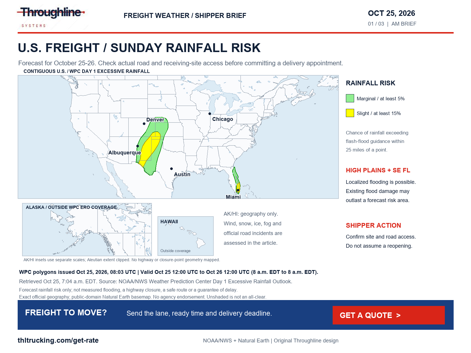
Sources: NOAA/NWS WPC excessive-rainfall discussion; NOAA/NWS WPC Day 1 rainfall-risk polygons
New Mexico and far west Texas: isolated severe storms remain possible
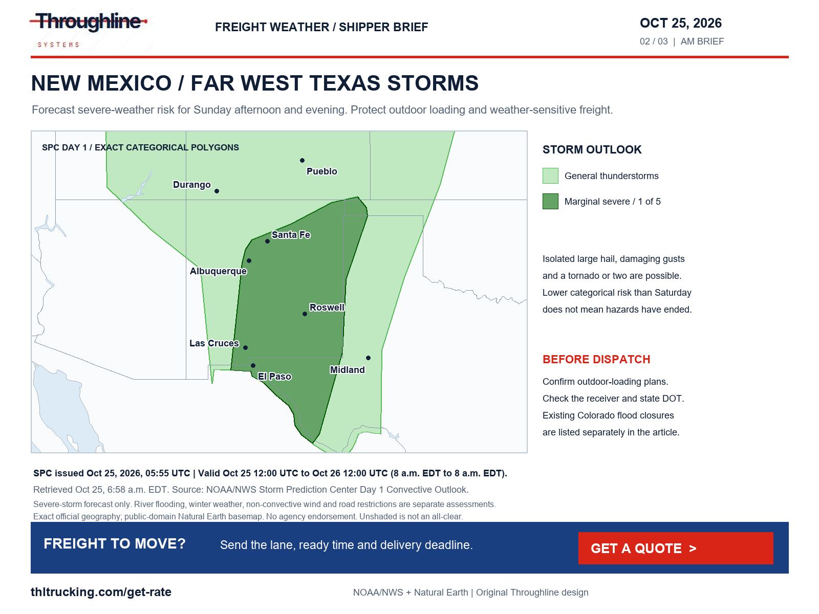
SPC’s 1:55 a.m. EDT October 25 outlook places central/eastern New Mexico and far west Texas in Marginal severe-thunderstorm risk, level 1 of 5, for 8 a.m. EDT Sunday through 8 a.m. EDT Monday. The discussion highlights isolated large hail, a tornado or two and isolated damaging gusts, with the main concern Sunday afternoon and evening.
This is a lower categorical outlook than Saturday’s Slight risk, not confirmation that conditions or roads have recovered. Shippers using open-deck equipment should agree with the site team how outdoor loading and weather protection will be handled if storms develop. Keep any change to the freight-ready time visible to the provider and receiver.
Confirmed road restrictions: Colorado flooding and Michigan construction
COtrip’s safety announcement remained accessible in the morning check and listed the following closures. Its issue time was displayed relatively as “3 days ago at 9:53 PM,” without an unambiguous time zone; the table records the extents actually displayed. No reopening time is established by this briefing.
These are transport-agency closure reports. NWS also continued flood warnings in southern Colorado and northern New Mexico, including ongoing/forecast major flooding at the San Juan River near Shiprock. The Shiprock warning was issued October 24 at 11:01 p.m. MDT and extends until October 26 at 3 a.m. MDT; its discussion notes the absence of current observed gauge data. A river warning alone does not identify a highway closure.
Michigan’s freshly checked construction records still list EB I-96 from 5 Mile Road to EB M-14 closed October 24–25, with weekend hours of 6 a.m.–7 p.m.; Detroit SB I-75 from SB I-375 to SB M-10/NB I-75 closed through October 25, without a reopening clock time; and the SB I-275 ramp to NB I-75 closed through October 27. The last item is a ramp closure. An end date is not proof that work has finished.
Before sending the truck, confirm the current restriction and the final approach with the provider and facility. If a different approach is proposed, have the provider check its suitability for the actual truck and load. Do not translate a map’s unshaded area into a verified detour or a promised arrival time.
| Colorado road | Closure extent listed by COtrip | Reported cause |
|---|---|---|
| US 160 | Mile points 150–183 | Debris following flooding |
| CO 112 | Mile points 1–13, Del Norte–Center; both directions | Flooding |
| US 285 | Mile points 51.2–55.85, north of Monte Vista; both directions | Flooding |
| CO 151 | Mile points 22–34, Chimney Rock–Arboles area | Flooding and debris |
Sources: Colorado DOT COtrip safety-closure announcement; NWS San Juan River at Shiprock flood warning; Michigan DOT Mi Drive construction list
Atlantic Florida and coastal Georgia: wind advisories through this evening
NWS land-zone advisories call for northeast winds of 15–25 mph, with gusts up to 35 mph along east-central Florida’s Atlantic coast and up to 40 mph in the northeast Florida/coastal southeast Georgia advisory area. The notices were issued October 25 at 2:12 a.m. EDT and October 24 at 8:22 p.m. EDT respectively, and both run through 8 p.m. EDT October 25 unless updated earlier.
For lumber, building materials and other exposed freight, confirm the site’s plan for handling tarps and loose materials during loading and unloading. These advisories are weather forecasts. They do not establish a high-profile vehicle ban, bridge closure or a specific delay duration.
The national alert scan also found Alaska High Wind Watches: Bering Strait coast/St. Lawrence Island from Monday afternoon through Tuesday afternoon, and the western Arctic coast’s Lisburne Peninsula from Monday evening through Tuesday evening. Notices issued October 25 at 2:45 and 2:43 a.m. AKDT forecast gusts up to 60 mph as possible. Alaska road restrictions were not independently verified.
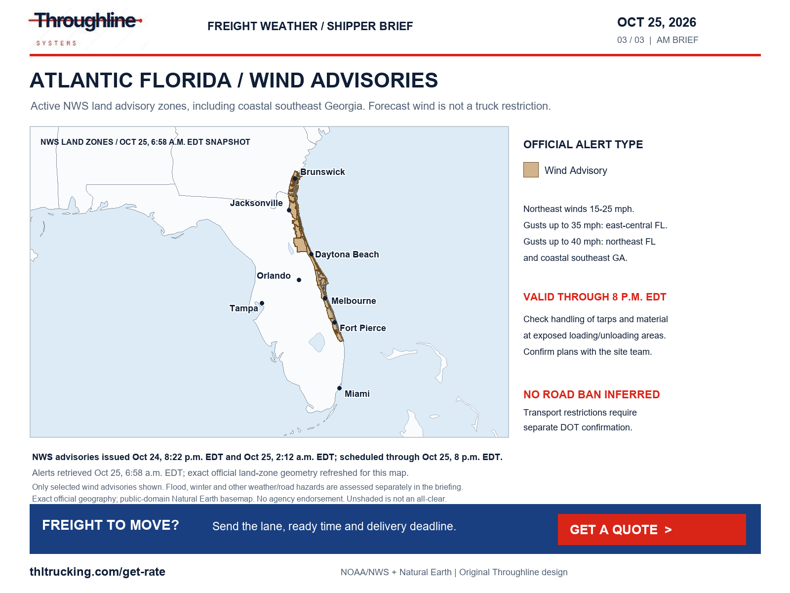
Sources: NWS Melbourne Atlantic Florida wind advisory; NWS Jacksonville northeast Florida/coastal Georgia wind advisory; NOAA/NWS national active-alert feed
Snow, ice and fog: different hazards need different checks
WPC’s 4:07 a.m. EDT October 25 winter discussion covers 8 a.m. EDT October 25 through 8 a.m. EDT October 28. For the first 24 hours, it assigns a 30–60% chance of more than 4 inches of additional snow after 8 a.m. EDT in the higher San Juan and Sangre de Cristo mountains, and a 40–60% chance of more than 6 inches over the highest southern Washington/Oregon Cascades. These are elevation-dependent forecast probabilities, not measured pavement accumulation or chain orders.
Alaska has substantial winter hazards as well. The south slopes of the central Brooks Range warning issued at 2:38 a.m. AKDT October 25 forecasts 8–16 inches of snow and gusts up to 35 mph through 10 p.m. AKDT Monday. Central Susitna Valley’s advisory, issued October 24 at 9:38 p.m. AKDT and scheduled through 8 a.m. AKDT Sunday, includes up to 3 inches of snow and 0.1–0.2 inch of ice. Confirm both road and site conditions for affected shipments; these amounts apply only to the named alert areas and periods.
Michigan dense-fog advisories issued around 3 a.m. EDT October 25 cover Ingham/Jackson through 9 a.m. EDT and portions of southeast Michigan through 10 a.m. EDT, with visibility one-quarter mile or less. Wyoming’s South Laramie Range advisory, issued at 12:19 a.m. MDT, runs through 10 a.m. MDT. Ask the receiver about check-in flexibility if visibility affects the approach.
WYDOT’s I-80 report separately lists dry pavement with fog and limited visibility between Laramie and Exit 348/Otto Road. The Laramie–Buford segments were timestamped 12:45 a.m. MDT October 25 and Buford–Otto Road 4:39 a.m. MDT. Those selected rows listed no restriction; that is a time-stamped segment report, not an assurance for the entire route. The Higley Boulevard overpass at Exit 214 near Rawlins also remains listed closed for bridge damage; the report does not describe that as an I-80 mainline closure.
Sources: NOAA/NWS WPC snow and icing discussion; NWS south slopes of the central Brooks Range winter storm warning; NWS Central Susitna Valley winter weather advisory; NOAA/NWS national active-alert feed; WYDOT I-80 conditions and restrictions
Diesel: the latest week is still October 19
EIA’s latest available on-highway diesel observation remains October 19, released October 20. The U.S. average is $6.276 per gallon, up $0.097 from $6.179 on October 12. Prices include taxes. EIA lists October 27 as the next release; these are weekly comparisons, not a Sunday price change.
For Monday’s freight, ask whether fuel is included in the quote, which index and observation week apply to any separate surcharge, and when the offer expires. The national and regional averages below do not determine the rate or fuel charge for a particular shipment.
| EIA geography | Oct. 19 USD/gallon | Change vs Oct. 12 |
|---|---|---|
| U.S. | $6.276 | +$0.097 |
| East Coast | $5.984 | +$0.076 |
| Midwest | $6.352 | +$0.093 |
| Gulf Coast | $5.903 | +$0.094 |
| Rocky Mountain | $6.422 | +$0.120 |
| West Coast | $7.394 | +$0.154 |
Sources: EIA gasoline and diesel fuel update
Monday’s rail-export rule: effective date and enforcement are a year apart
CBP’s electronic export manifest final rule for cargo leaving the U.S. by rail for Canada or Mexico becomes effective October 26, 2026. CBP states that enforcement begins October 26, 2027. This is a reminder about the approaching effective date of a rule published August 26, not a new Sunday announcement or an immediate border shutdown.
Manufacturers and distributors with cross-border rail freight can use the transition to identify who files the manifest and reconcile cargo descriptions, quantities, weights and shipment identifiers with the broker and railroad. Tie the domestic truck handoff to confirmed rail or terminal readiness. The notice does not establish a new restriction on ordinary domestic truck shipments.
Sources: CBP CSMS 69684363: electronic rail-export manifests; Federal Register: electronic export manifest for rail
Coverage and limits of this morning’s review
The national review checked NWS active alerts, SPC severe-weather outlooks and WPC rainfall, winter and short-range products. Categories assessed include high winds and gusts; severe thunderstorms, hail and tornadoes; snow, blowing snow, freezing rain, sleet and ice; flooding; fog, smoke, dust and other visibility or surface hazards. No material smoke or dust disruption was verified in those products and the transport sources reviewed. This is a scoped finding, not a nationwide all-clear.
Non-weather checks included Michigan construction and crash feeds, WYDOT I-80 roadwork/restrictions, Colorado’s accessible safety announcement and a New Mexico road-feed request. Construction, emergency repair, debris, slope failure, washout, wildfire closure and bridge/road damage were considered. The selected material restrictions are described above. This was not a complete 50-state incident inventory.
New Mexico’s response was incomplete JSON with stale top-level metadata, so it was not used to state current road conditions. Colorado’s full incident list had a verification-service connectivity gap; claims here are limited to the readable official notice. Alaska transport restrictions, Hawaii road conditions and individual Florida highway restrictions were not independently verified. No truck ban or chain requirement is inferred from weather alerts.
Official BNSF, Los Angeles and Georgia Ports notices were also reviewed. The latest reviewed BNSF network update remained October 23; the selected port releases did not establish a newer material terminal disruption for this briefing. This does not certify normal operations. Check the actual rail/transload or terminal handoff before dispatching freight.
The maps use exact current official hazard polygons or NWS zones, public-domain Natural Earth boundaries and original Throughline layouts. Each panel states its coverage and valid period. Agency data use does not imply endorsement; unshaded areas are not guaranteed safe.
Sources: NOAA/NWS national active-alert feed; NOAA/NWS SPC Day 1 convective outlook; NOAA/NWS WPC excessive-rainfall discussion; NOAA/NWS WPC snow and icing discussion; Michigan DOT Mi Drive construction list; WYDOT I-80 conditions and restrictions; Colorado DOT COtrip safety-closure announcement; BNSF October 23 Industrial Products Network Update; Port of Los Angeles news archive; Georgia Ports press releases
Put the decision-ready shipment details in one request
For FTL or partial open-deck and enclosed freight, send the lane, actual ready time, receiving deadline and time zones, packaged dimensions, weight, piece count, loading/unloading method and protection requirements. Include confirmed access changes and the person who can approve an appointment adjustment.
For an urgent smaller shipment, provide its exact packaged dimensions and weight before asking whether expedited sprinter service fits. Have the provider confirm equipment suitability, availability and the service plan. Use Get a quote to share the current shipment facts, and update them if a closure, site condition or ready time changes.
Sources and editorial notes
Original analysis by Throughline Systems. Source links may show newer releases after this article’s publication; the observation and issue dates below identify the material used. Agency citations do not imply endorsement.
- NOAA/NWS WPC excessive-rainfall discussion
Issued October 25, 4:12 a.m. EDT; Day 1 valid October 25 12:00 UTC–October 26 12:00 UTC.
Accessed .
- NOAA/NWS WPC Day 1 rainfall-risk polygons
Issued October 25 08:03 UTC; valid October 25 12:00 UTC–October 26 12:00 UTC. Endpoint updates.
Accessed .
- NOAA/NWS SPC Day 1 convective outlook
Issued October 25 05:55 UTC; valid October 25 12:00 UTC–October 26 12:00 UTC.
Accessed .
- NOAA/NWS WPC snow and icing discussion
Issued October 25, 4:07 a.m. EDT; valid October 25 12:00 UTC–October 28 12:00 UTC.
Accessed .
- NOAA/NWS national active-alert feed
October 25, 6:58 a.m. EDT snapshot; individual issue/valid times vary as stated in the article. Live endpoint updates.
Accessed .
- NWS San Juan River at Shiprock flood warning
Issued October 24 11:01 p.m. MDT; valid until October 26 3 a.m. MDT.
Accessed .
- NWS Melbourne Atlantic Florida wind advisory
Issued October 25 2:12 a.m. EDT; valid through October 25 8 p.m. EDT.
Accessed .
- NWS Jacksonville northeast Florida/coastal Georgia wind advisory
Issued October 24 8:22 p.m. EDT; valid through October 25 8 p.m. EDT.
Accessed .
- NWS south slopes of the central Brooks Range winter storm warning
Issued October 25 2:38 a.m. AKDT; valid through October 26 10 p.m. AKDT.
Accessed .
- NWS Central Susitna Valley winter weather advisory
Issued October 24 9:38 p.m. AKDT; valid through October 25 8 a.m. AKDT.
Accessed .
- Colorado DOT COtrip safety-closure announcement
Checked October 25 about 7:03 a.m. EDT. Issue displayed relatively: 3 days ago at 9:53 PM; time zone not unambiguous.
Accessed .
- WYDOT I-80 conditions and restrictions
Checked October 25 6:58 a.m. EDT; selected fog rows updated October 25 at 12:45 and 4:39 a.m. MDT.
Accessed .
- Michigan DOT Mi Drive construction list
Checked October 25 6:58 a.m. EDT; individual construction schedules stated in article.
Accessed .
- EIA gasoline and diesel fuel update
Release October 20; October 19 observation compared with October 12, USD/gallon including taxes. Next listed release October 27.
Accessed .
- CBP CSMS 69684363: electronic rail-export manifests
Published August 28, 2026 at 1:24 p.m. EDT; effective date October 26, 2026, enforcement October 26, 2027.
Accessed .
- Federal Register: electronic export manifest for rail
Final rule published August 26, 2026, 91 FR 55170–55227; effective/enforcement dates distinguished above.
Accessed .
- BNSF October 23 Industrial Products Network Update
October 23 operational update; no issue clock time provided. Reviewed October 25; not current train status.
Accessed .
- Port of Los Angeles news archive
Archive reviewed October 25; latest listed release October 22, not a live terminal-status feed.
Accessed .
- Georgia Ports press releases
Archive reviewed October 25; latest reviewed releases October 14 and October 7, not a live terminal-status feed.
Accessed .