October 26 logistics briefing: rail status, road access, wind and snow
Monday freight decisions: Laguna rail-status checks, confirmed road closures, Florida wind and coastal flooding, Montana snow and the latest weekly EIA diesel data.
By Throughline Systems · · 11 min read
What matters for your next load
- Confirm the release status of rail-dependent material after BNSF’s Laguna incident notice; estimated track openings are not proof of restoration.
- Recheck Four Corners, North Carolina and Michigan access before fixing pickup and delivery appointments. Florida wind/coastal flooding and overnight Montana snow require separate planning.
- EIA’s latest weekly diesel observation remains October 19: $6.276 per gallon nationally, up $0.097 from October 12.
Monday starts with an access check, not a nationwide delay assumption
For manufacturers, lumber suppliers and distributors, the immediate question is whether the shipment can reach an open receiving operation. This morning brings a newly reviewed BNSF incident notice, continuing Four Corners road closures, Florida wind and coastal-flood warnings, and a southwest Montana snow advisory for tonight. Each has a different geography and clock.
This is an October 26 morning snapshot, with core weather data retrieved at 7:06 a.m. EDT and selected road reports checked afterward. Forecasts describe possible conditions; transport-agency entries establish the specific restrictions listed below. Neither establishes a delay duration for your shipment. Confirm conditions again before release.
Sources: BNSF: Laguna track washout / derailment initial report; UDOT current alerts; NWS national active-alert snapshot
Laguna rail incident: ask for shipment status before booking the truck connection
BNSF’s October 25 initial report describes a track washout and derailment near Laguna, New Mexico, on the Gallup Subdivision. The railroad says the preliminary report arrived October 24 at about 5:20 p.m. CDT. It lists estimated main-track openings during October 25; those estimates have passed, but the notice reviewed this morning does not confirm that service was restored.
If inbound material depends on this rail movement, obtain the shipment’s actual release status and latest arrival estimate before fixing a transload pickup or downstream delivery appointment. Ask the receiving plant which materials are essential to the next production run. An urgent truck move for a small critical subset is a planning option to evaluate, not evidence that the entire rail shipment needs conversion or that truck capacity is available.
Sources: BNSF: Laguna track washout / derailment initial report
Diesel remains a weekly benchmark: latest observation October 19
EIA’s page retrieved this morning still identifies October 19 as the latest weekly U.S. on-highway diesel observation, released October 20. The national average is $6.276 per gallon including taxes, up $0.097 from October 12. The page lists October 27 as the next release. This is not a new Monday price observation.
The October 19 regional readings include $6.352 per gallon in the Midwest and $5.903 in the Gulf Coast. These retail averages do not establish a lane rate or a provider’s fuel surcharge. For a quote extending into next week, confirm the index, observation week, calculation and validity period used in the actual offer.
National outlook: localized rainfall risk, with other hazards assessed separately
WPC’s Day 1 outlook carries Marginal excessive-rainfall risk over parts of the central and southern High Plains and southeast Florida. It is valid from 8 a.m. EDT October 26 to 8 a.m. EDT October 27. The mapped category means at least a 5% chance of rainfall exceeding flash-flood guidance within 25 miles of a point. It is a forecast, not observed flooding or a highway closure.
SPC’s 12:19 a.m. CDT Day 1 outlook forecasts no severe-thunderstorm risk areas for that same 12:00 UTC-to-12:00 UTC period. General thunderstorms remain possible in parts of the country. This does not remove flood, wind, winter or road risks, and it does not guarantee clear conditions at an individual loading site.
WPC’s 4:34 a.m. EDT winter discussion, covering October 26–29, identifies mountain-snow concerns in the Cascades and northern Rockies and a potential light-snow band in the northern Plains. Use the local advisory and transport report for the actual shipment time; a three-day regional discussion is not a pass-status report.
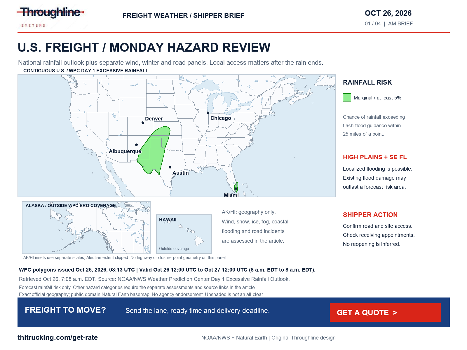
Sources: WPC excessive rainfall discussion; WPC Day 1 exact rainfall-risk polygons; SPC Day 1 convective outlook; WPC heavy snow and icing discussion
Confirmed road reports: flooding, crashes, debris and bridge damage
These are selected official road reports, not a national closure inventory. UDOT, WYDOT and DriveNC display update times without a time-zone label in the retrieved lists; those times are quoted as displayed. The source notes record retrieval times in UTC. An old incident disappearing from a feed is not treated as a confirmed reopening.
The separate NWS San Juan River Flood Warning, issued October 25 at 2:07 p.m. MDT and valid through 6 a.m. MDT October 27, forecasts catastrophic flooding between Four Corners and Mexican Hat, including the Bluff/Montezuma Creek area. Its forecast is distinct from the UDOT/CDOT closures below. Existing river impacts can persist after additional rainfall ends; do not assume a usable industrial or local access road from the national rainfall map.
For each affected shipment, have the provider verify the complete planned access path and the receiver confirm its gate, yard and unloading crew. Do not substitute a map app’s alternate route for equipment and restriction checks.
| Location | Official status at review | Practical action |
|---|---|---|
| Utah SR-162, MP 1–17, US-191 junction at Bluff through Montezuma Creek | Both directions closed for flooding; UDOT entry updated October 25 at 10:11 p.m. | Confirm cross-border access before releasing Four Corners freight. |
| Colorado US-160 MP 150–183 and MP 1–18; CO-151 MP 22–34 | COtrip continues to list flood/debris or safety closures. Its announcement warns that CO-41 / UT-162 is not a through route. | Check the actual origin-to-receiver access plan; no reopening is assumed. |
| Utah WB SR-201 ramp to WB I-80 | Ramp closed for a crash; UDOT update October 26 at 5:03 a.m. | Recheck this ramp before a Salt Lake/Tooele-area pickup. |
| North Carolina I-85 northbound at Exit 22, Gaston County | DriveNC lists a crash closure, updated October 26 at 4:05 a.m. | Reconfirm status before committing an arrival window west of Charlotte. |
| North Carolina NC-12 near Rodanthe, Dare County | Both directions closed for flooding; DriveNC entry updated October 23 at 4:37 p.m. and still present in today’s list. | Coordinate island delivery access with the receiver and transport provider. |
| Wyoming I-80, Exit 323 Happy Jack Road to Exit 335 Buford | WYDOT lists fog and wet/rain conditions, with an October 26 1:06 a.m. condition report. | Check updated visibility and road conditions before dispatch. |
| Rawlins, Wyoming: Higley Boulevard overpass at I-80 Exit 214 | WYDOT lists the overpass closed for bridge damage; this is not an I-80 mainline closure. | Confirm local industrial-site access rather than assuming the exit-area connection is usable. |
Sources: UDOT current alerts; CDOT COtrip safety-closure announcement; WYDOT I-80 conditions and restrictions; NCDOT DriveNC special alerts; NWS Flood Warning: Montezuma, CO; San Juan, UT
Michigan: a morning crash closure and scheduled construction
MDOT’s 7:08 a.m. EDT snapshot lists both directions of M-32 at Hall Road in Montmorency County closed for a crash; the record displays a 7:00 a.m. report time. Recheck before an affected delivery because incident status can change after this snapshot.
The construction feed separately lists US-31 from Bennett Road to Maple Hill Road in Antrim County closed during scheduled work October 19–November 6. Northbound I-196 from 124th Street to 68th Street in Allegan County has stoppages listed for October 26–27. Those are work schedules, not a promise of a continuous closure or an exact reopening. Ask the receiving team whether its unloading window can accommodate a revised arrival.
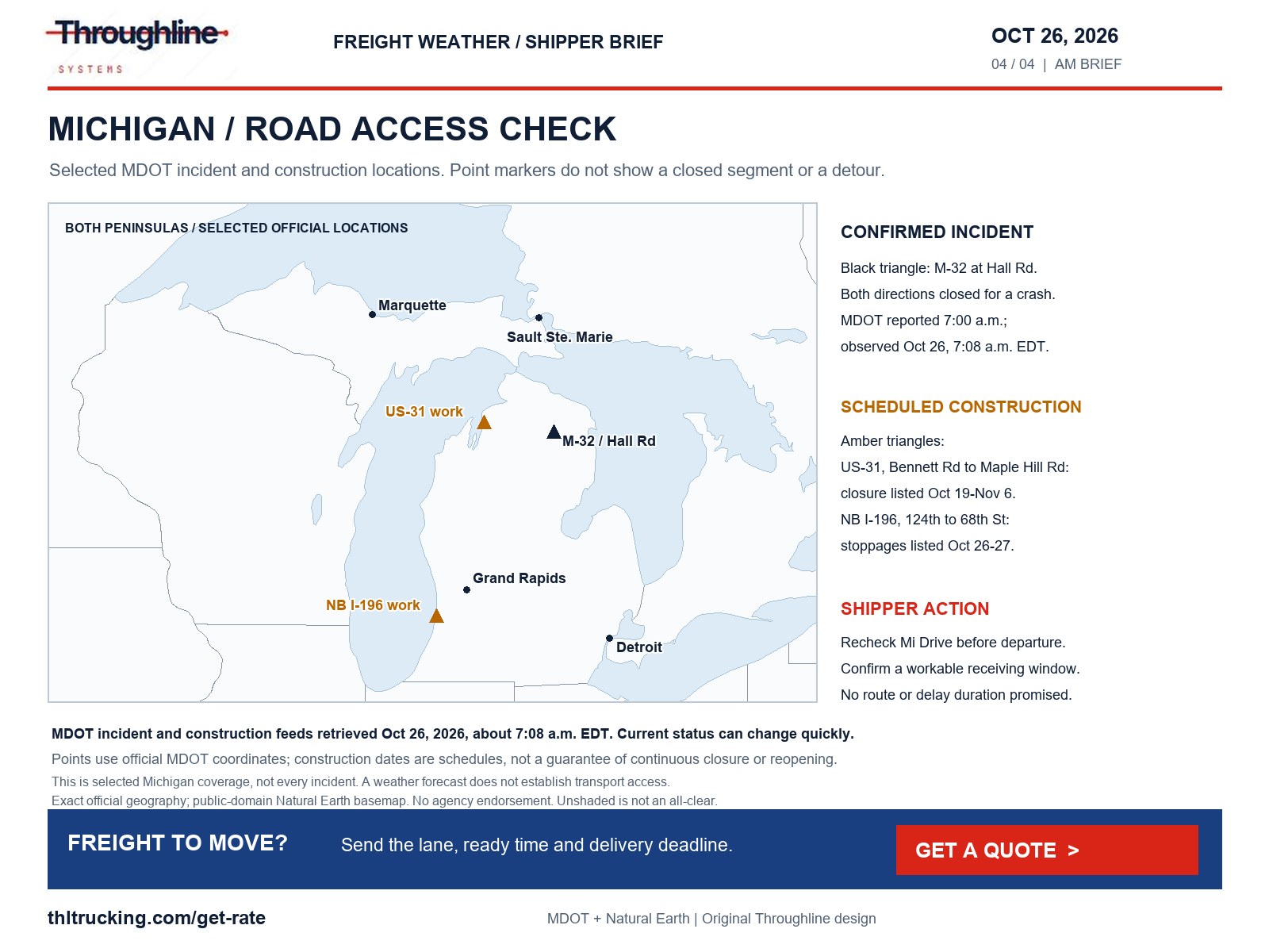
Sources: MDOT Mi Drive incident feed; MDOT Mi Drive construction feed
Florida wind advisories extend into the new week
East-central Florida’s advisory covers coastal Volusia, Indian River, St. Lucie and Martin, plus mainland and barrier-island Brevard zones. The Melbourne office’s October 25, 11:53 p.m. EDT issue forecasts northeast winds of 20–25 mph and gusts to 35 mph through 8 p.m. EDT today.
For metro and coastal Palm Beach, Broward and Miami-Dade, the Miami office’s October 26, 1:18 a.m. EDT advisory runs from 11 a.m. today through 8 p.m. EDT Tuesday, October 27: northeast winds 20–25 mph with frequent 40 mph gusts. Open-deck shippers should confirm how the site will handle tarps, loose packaging and exposed loading; enclosed freight still needs a usable dock and access road.
Wyoming’s separate High Wind Watch, issued October 26 at 2:32 a.m. MDT, covers the Green Mountains/Rattlesnake Range and lower elevations of Natrona County from late Monday night through Tuesday afternoon. Southwest winds of 30–40 mph with gusts to 60 mph are possible. This is a watch, and no high-profile vehicle restriction is inferred from it.
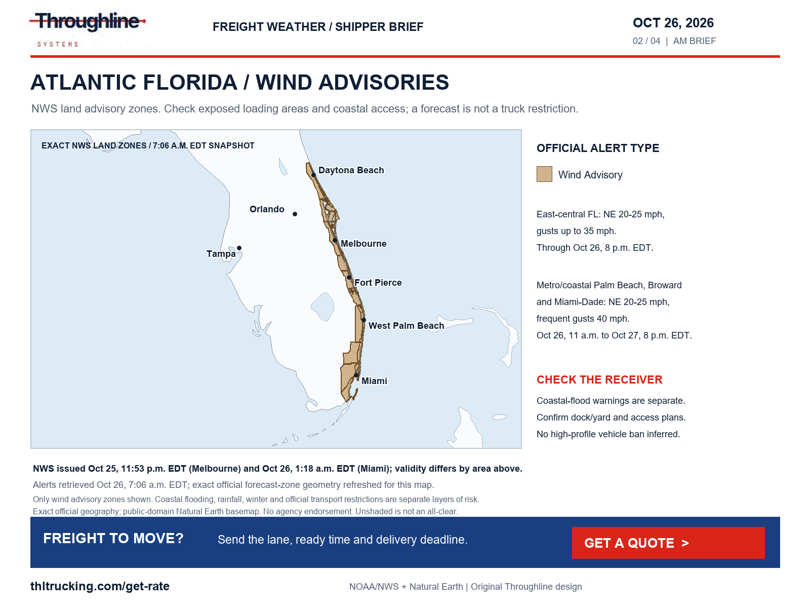
Sources: NWS Wind Advisory: Coastal Volusia; Coastal Indian River; Coastal St. Lucie; Coastal Martin; Mainland Northern Brevard; Northern Brevard Barrier Islands; Mainland Southern Brevard; Southern Brevard Barrier Islands; NWS Wind Advisory: Metro Palm Beach County; Metro Broward County; Metropolitan Miami Dade; Coastal Palm Beach County; Coastal Broward County; Coastal Miami Dade County; NWS High Wind Watch: Green Mountains and Rattlesnake Range; Natrona County Lower Elevations
Coastal flooding can affect the final miles even outside the rainfall-risk map
The national NWS scan includes significant coastal-flood warnings along Atlantic Florida. East-central coastal zones are warned through 2 a.m. EDT Thursday, October 29 (issued 1:39 a.m. today); coastal Palm Beach, Broward and Miami-Dade through 8 p.m. EDT Wednesday, October 28 (issued 1:20 a.m.); and the Upper Keys through 5 a.m. EDT Tuesday, October 27 (issued 4:02 a.m.). These forecasts describe coastal inundation risk, not a verified closure of every coastal road.
Coastal Glynn and Camden in Georgia have a warning through 11 a.m. EDT Tuesday (issued 3:22 a.m. today), while coastal Colleton and Charleston, South Carolina, have a warning through 11 a.m. EDT today (issued 2:35 a.m.). San Diego and Orange County coastal areas have a warning through 1 p.m. PDT Thursday, October 29, focused on late-morning high tides (issued 1:28 a.m. PDT today).
For low-lying waterfront receivers, confirm the actual access road and yard condition with the facility before releasing freight. Ask whether a later receiving window is workable. A port-area weather warning alone does not establish a port or terminal shutdown.
Sources: NWS Coastal Flood Warning: Coastal Volusia; Coastal Indian River; Coastal St. Lucie; Coastal Martin; Mainland Northern Brevard; Northern Brevard Barrier Islands; Mainland Southern Brevard; Southern Brevard Barrier Islands; NWS Coastal Flood Warning: Coastal Broward County; Coastal Miami Dade County; NWS Coastal Flood Warning: Monroe Upper Keys; NWS Coastal Flood Warning: Coastal Glynn; Coastal Camden; NWS Coastal Flood Warning: Coastal Colleton; Charleston; NWS Coastal Flood Warning: San Diego County Coastal Areas; Orange County Coastal; NWS Coastal Flood Warning: Coastal Palm Beach County
Southwest Montana: morning fog and a separate overnight snow period
NWS Great Falls issued a Winter Weather Advisory at 3:19 a.m. MDT today for the Gallatin and Madison County Mountains and Centennial Mountains. It is valid from 9 p.m. MDT October 26 to 6 a.m. MDT October 27, with total snow of 2–5 inches and gusts up to 40 mph. These totals cover the full advisory period and do not apply to all of Montana.
A broader southwest Montana Dense Fog Advisory, issued at 12:42 a.m. MDT, lasts until noon MDT today and forecasts visibility of a quarter mile or less. It includes the Gallatin and Madison valleys and several neighboring mountain/valley zones. For tonight’s pickup or Tuesday receiving appointment, confirm the provider’s current road check and the site’s staffing plan. No Montana chain requirement or closure was independently verified in this review.
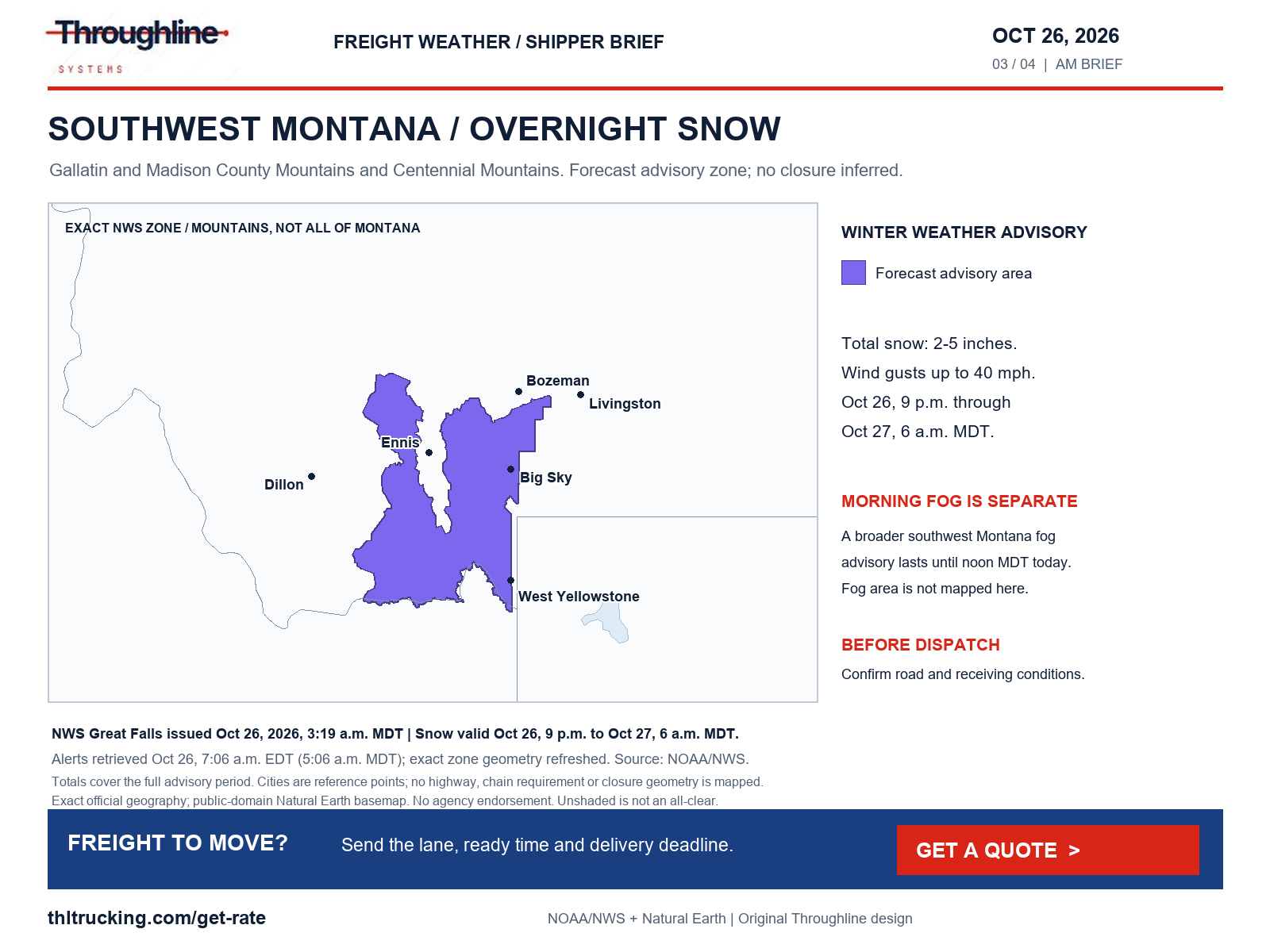
Sources: NWS Winter Weather Advisory: Gallatin and Madison County Mountains and Centennial Mountains; NWS Dense Fog Advisory: Elkhorn and Boulder Mountains; Canyon Ferry Area; Missouri Headwaters; Madison River Valley; Gallatin Valley; Northwest Beaverhead County; Beaverhead and Western Madison below 6000ft; Gallatin and Madison County Mountains and Centennial Mountains
Alaska, Hawaii, fire and the limits of this review
Alaska remains part of the national scan. A High Wind Warning issued at 2:28 a.m. AKDT today covers Shishmaref, the Bering Strait Coast and St. Lawrence Island from 4 p.m. October 26 to 4 p.m. October 27, with forecast gusts of 50–60 mph. The Upper Koyukuk Valley Winter Storm Warning, issued at 2:40 a.m. AKDT, lists 8–12 inches total snow through 10 p.m. AKDT today. Other interior Alaska advisories include snow and light icing; no Alaska highway restriction is inferred.
Hawaii’s October 25, 3:08 p.m. HST hydrologic outlook identifies a possible heavy-rain period from late Monday night through Thursday. The outlook leaves the most affected locations uncertain. It is an advance planning signal for local receiving operations, not a confirmed transport disruption.
The latest NIFC report returned during research was dated October 25 at 7:30 a.m. MDT. It lists area, road and trail closures associated with the Austin fire southeast of Estacada, Oregon, and the Sisi fire northwest of Stehekin, Washington. This review did not verify a specific freight-highway closure from those fires. Remote or forest-access deliveries need a current local authority check.
Every review category was checked: high wind; severe storms, hail and tornado risk; snow, blowing snow, blizzard, freezing rain, sleet and ice; river/coastal flooding; fog, smoke and dust; and non-weather crashes, construction, debris, landslides, washouts, fire and bridge/road damage. The active-alert snapshot did not return a blizzard, dust or dense-smoke alert, which is not an all-clear. Road checks were selective in Colorado, Utah, Wyoming, Michigan and North Carolina. The downloaded New Mexico feed carried a 2020 update header and was not accepted as current; Montana’s 511 detail view was not verified. Alaska road access, all local roads, all terminals and later changes remain coverage gaps.
Sources: NWS High Wind Warning: Shishmaref; Bering Strait Coast; St Lawrence Island; NWS Winter Storm Warning: Upper Koyukuk Valley; NWS Hydrologic Outlook: Hawaii in Hawaii, HI; Oahu in Honolulu, HI; Kauai, HI; Maui, HI; NIFC national incident situation report; NWS national active-alert snapshot
A useful release plan for today’s freight
For FTL or partial freight, share the true ready time, packed dimensions and weight, equipment requirements, unloading method and latest usable delivery time. Identify whether a missed appointment would stop production or simply move replenishment to another day. That distinction helps the provider evaluate a dedicated truck, a compatible partial plan or an urgent subset without inventing a guaranteed arrival.
For open-deck lumber or machinery, confirm protection and exposed handling at both ends. For enclosed shipments, verify the dock and appointment rather than assuming weather protection solves road access. For a small urgent production shipment, ask whether a Sprinter or other expedited vehicle fits the actual cargo and loading arrangement; service, capacity and timing still require confirmation.
Use the linked guides to prepare those details, then request a quote for the actual shipment. This briefing is a planning snapshot and does not establish a booked truck, a safe alternate route or a promised delivery time.
Sources and editorial notes
Original analysis by Throughline Systems. Source links may show newer releases after this article’s publication; the observation and issue dates below identify the material used. Agency citations do not imply endorsement.
- EIA: weekly U.S. on-highway diesel prices
Released October 20, 2026; observation October 19; next release shown October 27. Dollars per gallon, including taxes.
Accessed .
- BNSF: Laguna track washout / derailment initial report
Dated October 25, 2026; incident reported October 24 at approximately 5:20 p.m. CDT. Page has no publication time.
Accessed .
- SPC Day 1 convective outlook
Issued October 26 at 12:19 a.m. CDT; valid October 26 12:00 UTC–October 27 12:00 UTC.
Accessed .
- WPC excessive rainfall discussion
Issued October 26 at 4:14 a.m. EDT; Day 1 valid October 26 12:00 UTC–October 27 12:00 UTC.
Accessed .
- WPC Day 1 exact rainfall-risk polygons
Issued October 26 at 08:13 UTC; valid October 26 12:00 UTC–October 27 12:00 UTC.
Accessed .
- WPC heavy snow and icing discussion
Issued October 26 at 4:34 a.m. EDT; valid October 26 12:00 UTC–October 29 12:00 UTC.
Accessed .
- NWS national active-alert snapshot
Individual issue and valid times vary. Snapshot retrieved October 26 at 7:06 a.m. EDT; includes CONUS, Alaska and Hawaii.
Accessed .
- UDOT current alerts
Dynamic list retrieved October 26 about 7:08 a.m. EDT. Individual update times are reproduced as displayed; the list did not label their time zone.
Accessed .
- WYDOT I-80 conditions and restrictions
Page displayed October 26, 5:06 a.m. update; individual condition time differs. Retrieved about 7:08 a.m. EDT; displayed time zone not labeled.
Accessed .
- MDOT Mi Drive incident feed
Current snapshot October 26 about 7:08 a.m. EDT; M-32 record displayed 7:00 a.m. without a date/time-zone field.
Accessed .
- MDOT Mi Drive construction feed
Retrieved October 26 about 7:08 a.m. EDT. Dates are scheduled work windows, not confirmed reopening times.
Accessed .
- NCDOT DriveNC special alerts
NC-12 update displayed October 23 at 4:37 p.m.; I-85 update October 26 at 4:05 a.m. Displayed time zone not labeled.
Accessed .
- NIFC national incident situation report
Latest PDF returned at retrieval: October 25, 2026, 7:30 a.m. MDT; national incident summary, not a current highway-status feed.
Accessed .
- CDOT COtrip safety-closure announcement
Live announcement viewed October 26 about 7:14 a.m. EDT; UI displayed “4 days ago at 9:53 PM,” without a time zone.
Accessed .
- NWS Wind Advisory: Metro Palm Beach County; Metro Broward County; Metropolitan Miami Dade; Coastal Palm Beach County; Coastal Broward County; Coastal Miami Dade County
Issued 2026-10-26T01:18:00-04:00; onset 2026-10-26T11:00:00-04:00; ends 2026-10-27T20:00:00-04:00 (source timestamps).
Accessed .
- NWS Wind Advisory: Coastal Volusia; Coastal Indian River; Coastal St. Lucie; Coastal Martin; Mainland Northern Brevard; Northern Brevard Barrier Islands; Mainland Southern Brevard; Southern Brevard Barrier Islands
Issued 2026-10-25T23:53:00-04:00; onset 2026-10-25T23:53:00-04:00; ends 2026-10-26T20:00:00-04:00 (source timestamps).
Accessed .
- NWS Winter Weather Advisory: Gallatin and Madison County Mountains and Centennial Mountains
Issued 2026-10-26T03:19:00-06:00; onset 2026-10-26T21:00:00-06:00; ends 2026-10-27T06:00:00-06:00 (source timestamps).
Accessed .
- NWS Dense Fog Advisory: Elkhorn and Boulder Mountains; Canyon Ferry Area; Missouri Headwaters; Madison River Valley; Gallatin Valley; Northwest Beaverhead County; Beaverhead and Western Madison below 6000ft; Gallatin and Madison County Mountains and Centennial Mountains
Issued 2026-10-26T00:42:00-06:00; onset 2026-10-26T00:42:00-06:00; ends 2026-10-26T12:00:00-06:00 (source timestamps).
Accessed .
- NWS High Wind Watch: Green Mountains and Rattlesnake Range; Natrona County Lower Elevations
Issued 2026-10-26T02:32:00-06:00; onset 2026-10-27T04:00:00-06:00; ends 2026-10-27T15:00:00-06:00 (source timestamps).
Accessed .
- NWS Coastal Flood Warning: San Diego County Coastal Areas; Orange County Coastal
Issued 2026-10-26T01:28:00-07:00; onset 2026-10-26T01:28:00-07:00; ends 2026-10-29T13:00:00-07:00 (source timestamps).
Accessed .
- NWS Coastal Flood Warning: Coastal Volusia; Coastal Indian River; Coastal St. Lucie; Coastal Martin; Mainland Northern Brevard; Northern Brevard Barrier Islands; Mainland Southern Brevard; Southern Brevard Barrier Islands
Issued 2026-10-26T01:39:00-04:00; onset 2026-10-26T01:39:00-04:00; ends 2026-10-29T02:00:00-04:00 (source timestamps).
Accessed .
- NWS Coastal Flood Warning: Coastal Broward County; Coastal Miami Dade County
Issued 2026-10-26T01:20:00-04:00; onset 2026-10-26T02:00:00-04:00; ends 2026-10-28T20:00:00-04:00 (source timestamps).
Accessed .
- NWS Coastal Flood Warning: Monroe Upper Keys
Issued 2026-10-26T04:02:00-04:00; onset 2026-10-26T04:02:00-04:00; ends 2026-10-27T05:00:00-04:00 (source timestamps).
Accessed .
- NWS Coastal Flood Warning: Coastal Glynn; Coastal Camden
Issued 2026-10-26T03:22:00-04:00; onset 2026-10-26T03:22:00-04:00; ends 2026-10-27T11:00:00-04:00 (source timestamps).
Accessed .
- NWS Coastal Flood Warning: Coastal Colleton; Charleston
Issued 2026-10-26T02:35:00-04:00; onset 2026-10-26T05:00:00-04:00; ends 2026-10-26T11:00:00-04:00 (source timestamps).
Accessed .
- NWS Hydrologic Outlook: Hawaii in Hawaii, HI; Oahu in Honolulu, HI; Kauai, HI; Maui, HI
Issued 2026-10-25T15:08:00-10:00; onset 2026-10-25T15:08:00-10:00; alert expires 2026-10-26T06:00:00-10:00 (source timestamps).
Accessed .
- NWS High Wind Warning: Shishmaref; Bering Strait Coast; St Lawrence Island
Issued 2026-10-26T02:28:00-08:00; onset 2026-10-26T16:00:00-08:00; ends 2026-10-27T16:00:00-08:00 (source timestamps).
Accessed .
- NWS Winter Storm Warning: Upper Koyukuk Valley
Issued 2026-10-26T02:40:00-08:00; onset 2026-10-26T02:40:00-08:00; ends 2026-10-26T22:00:00-08:00 (source timestamps).
Accessed .
- NWS Coastal Flood Warning: Coastal Palm Beach County
Issued 2026-10-26T01:20:00-04:00; onset 2026-10-26T02:00:00-04:00; ends 2026-10-28T20:00:00-04:00.
Accessed .
- NWS Flood Warning: Montezuma, CO; San Juan, UT
Issued 2026-10-25T14:07:00-06:00; onset 2026-10-25T14:07:00-06:00; ends 2026-10-27T06:00:00-06:00.
Accessed .