October 27 logistics briefing: Wyoming wind limits, Cascades snow and shipper access
Tuesday freight planning: WYDOT I-80 vehicle restrictions, Cascades snow, High Plains fog, NM/Texas storm risk, Florida access and the latest available weekly diesel.
By Throughline Systems · · 12 min read
What matters for your next load
- WYDOT lists wind-related high-profile vehicle restrictions on I-80 from Rawlins to Laramie. Check the offered vehicle before release.
- Cascades snow starts this evening; morning High Plains fog, later NM/Texas severe-storm risk and Florida wind/flooding have different valid periods.
- EIA’s latest available observation at 8:10 a.m. EDT remains October 19: $6.276 per gallon nationally. A scheduled release is not yet a new price.
Tuesday’s freight decisions start with the vehicle and the receiving site
The clearest transport restriction in this morning’s review is on Wyoming I-80: WYDOT lists wind-related limits for high-profile vehicles between Rawlins and Laramie. Separately, Washington Cascades snow advisories begin this evening, dense fog affects parts of the High Plains this morning, and isolated severe storms are possible in southeast New Mexico and far west Texas later today.
For manufacturers, lumber suppliers and distributors, those are different planning problems. Confirm that the offered vehicle can operate under current restrictions, that the origin can load it, and that the destination can receive it. Core national weather and diesel sources were retrieved October 27 at 8:10 a.m. EDT; selected road and rail checks followed. This dated briefing does not establish a shipment’s delay duration.
Sources: WYDOT I-80 road report; NWS national active-alert snapshot; SPC Day 1 convective outlook
National overview: severe-storm and rainfall forecasts are separate layers
SPC’s 6:57 a.m. CDT outlook places a small part of southeast New Mexico and far west Texas in Marginal severe-thunderstorm risk, level 1 of 5. Its valid period is 13:00 UTC October 27 through 12:00 UTC October 28. WPC’s Day 1 Marginal excessive-rainfall area is in southeast Florida, valid 12:00 UTC October 27 through 12:00 UTC October 28. That rainfall category represents at least a 5% chance of rainfall exceeding flash-flood guidance within 25 miles of a point.
The map shows those two forecast products with their own legends and clocks. Wind, winter, fog, coastal and river flooding, wildfire access and official road incidents are reviewed below. Alaska and Hawaii insets show geography only because these CONUS outlook layers do not cover them; their hazards are included in the text. An unshaded area is not an all-clear.
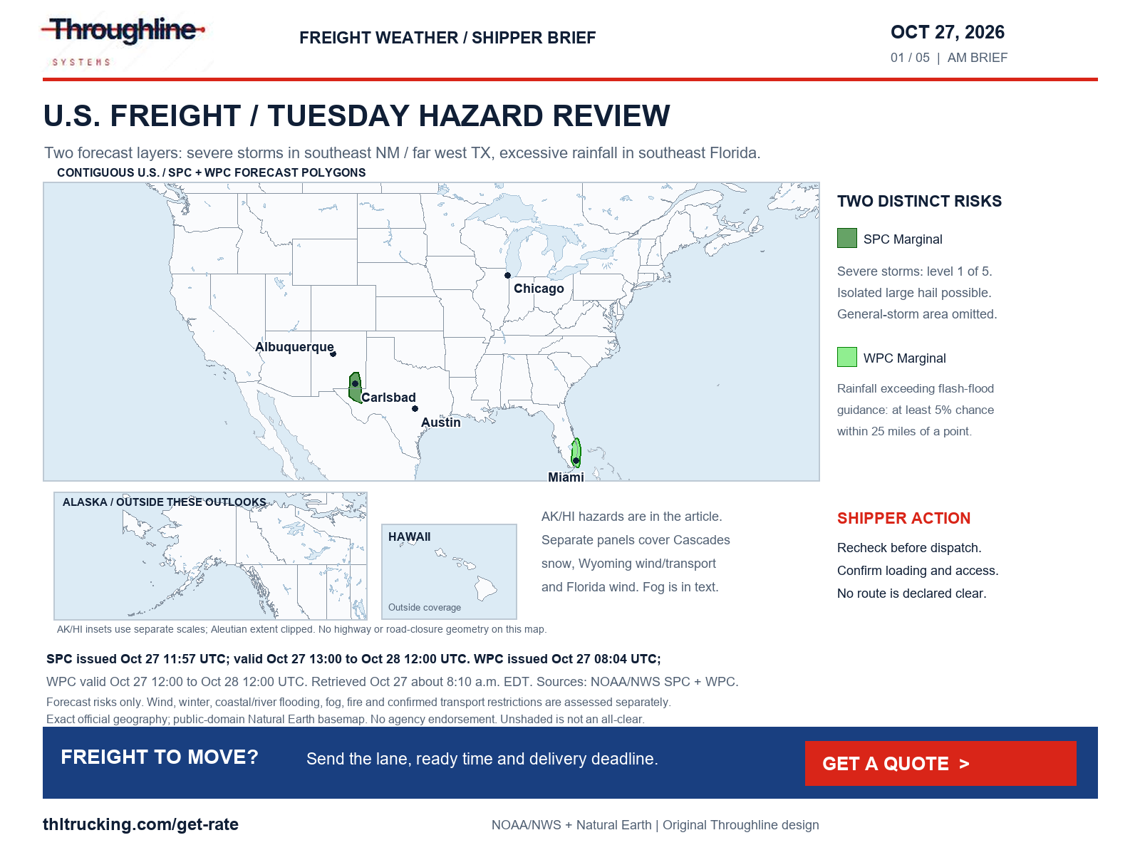
Sources: SPC Day 1 convective outlook; SPC exact Day 1 categorical polygons; WPC excessive-rainfall discussion; WPC exact Day 1 rainfall-risk polygons
Wyoming I-80: check the actual vehicle against WYDOT’s restriction
In the WYDOT report retrieved about 8:10 a.m. EDT, consecutive I-80 segments from Rawlins through Walcott Junction, Elk Mountain, Arlington and Quealy Dome to Laramie are closed to all high-profile vehicles under 35,000 GVW due to gusting winds. The rows show an October 27, 6:06 a.m. update without a time-zone label. This is a responsible transport authority’s restriction, not a closure inferred from a weather map.
The separate NWS High Wind Watch for the North Snowy Range Foothills and Converse County lower elevations, issued at 12:55 a.m. MDT, runs through noon MDT today. It forecasts southwest winds of 30–40 mph, with gusts to 60 mph possible and 50–55 mph more likely. The watch-zone boundaries do not define the road restriction.
Before releasing an affected FTL, partial or expedited move, have the transport provider confirm the vehicle’s eligibility and the latest WYDOT status. Give the receiver an updated appointment plan if the move cannot proceed. The Higley Boulevard overpass at I-80 Exit 214 near Rawlins also remains listed closed for bridge damage; that local overpass restriction is distinct from the I-80 mainline wind restriction.
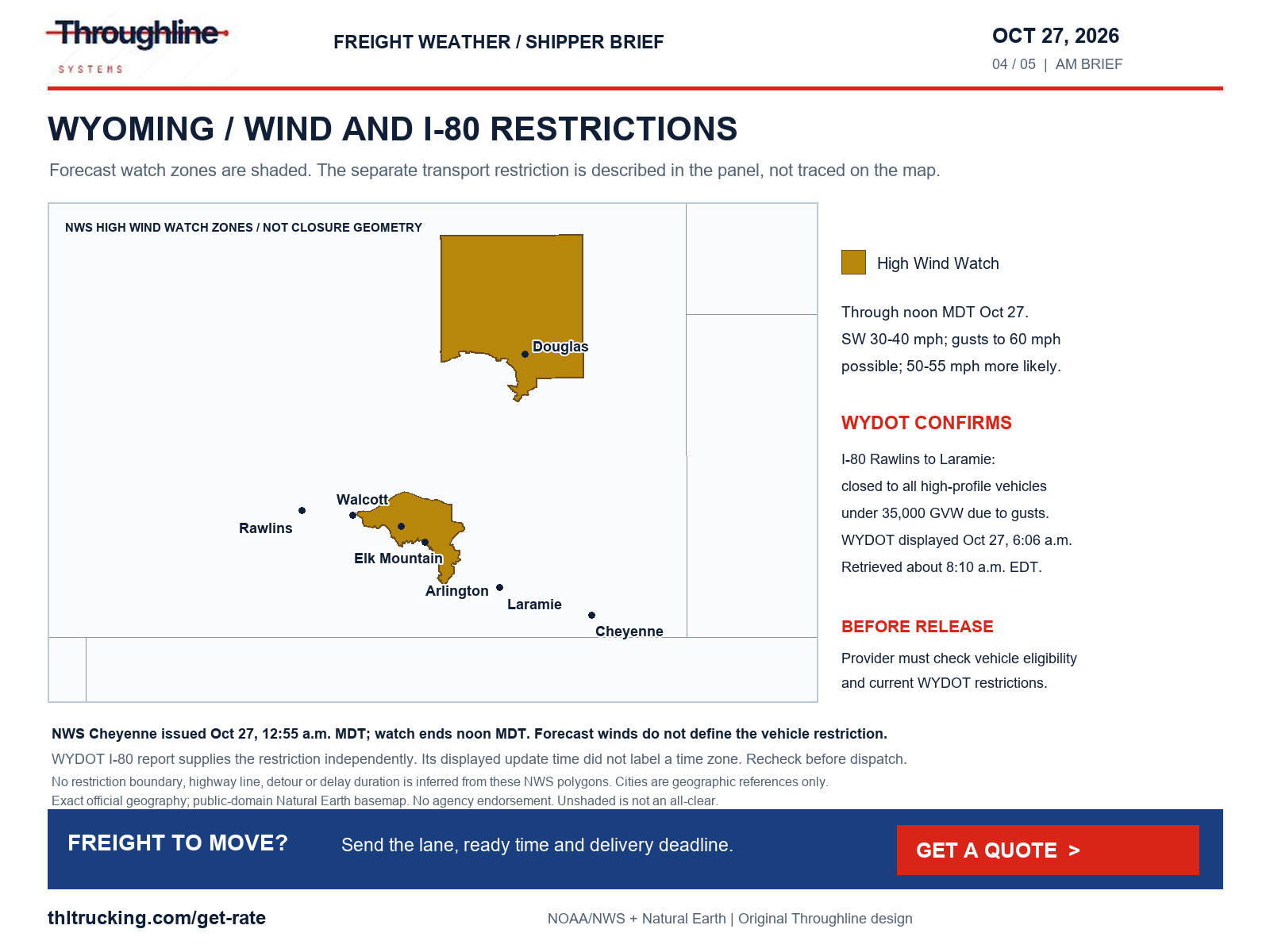
Sources: WYDOT I-80 road report; NWS High Wind Watch: North Snowy Range Foothills
Cascades snow tonight: confirm the pass and the receiving window
Washington’s advisories run from 5 p.m. PDT October 27 to 5 p.m. PDT October 28. The west-slope advisories issued at 4:22 a.m. PDT today forecast 4–8 inches in the Whatcom/Skagit and Snohomish/northern King mountain zones, heaviest above 4,000 feet. Southern King’s zone has 4–8 inches above 4,000 feet, with 1–3 inches at Snoqualmie Pass. Pierce/Lewis mountain zones have 6–12 inches, heaviest above 4,000 feet. These are full-period totals, not hourly snowfall rates.
East-side advisories differ: the upper eastern crest has 3–7 inches above 4,000 feet and gusts to 35 mph; western Chelan/Okanogan has 2–8 inches above 3,000 feet, highest along the crest. Those notices were issued October 26 at 10:39 p.m. and 7:42 p.m. PDT respectively. WPC’s October 27–30 winter discussion also flags northern Idaho and northwest Montana mountain snow; it puts the probability of significant CONUS icing below 10%, which is not a guarantee of ice-free roads.
The WSDOT pass service returned seasonal text and no report date for Stevens/US-2 and Snoqualmie/I-90. Its undated restriction fields do not verify current access. Check the live transport report before departure and again before the mountain crossing. For open-deck freight, confirm weather protection and an unloading plan; enclosed equipment still needs a workable route and dock appointment.
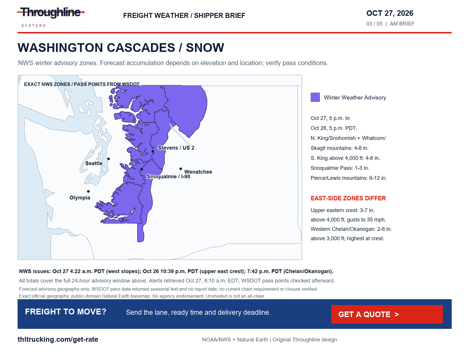
Sources: NWS Winter Weather Advisory: Cascades of Whatcom and Skagit Counties; Cascades of Snohomish and Northern King Counties; NWS Winter Weather Advisory: Cascades of Southern King County; NWS Winter Weather Advisory: Cascades of Pierce and Lewis Counties; NWS Winter Weather Advisory: Upper Slopes of the Eastern Washington Cascades Crest; NWS Winter Weather Advisory: Western Chelan County; Western Okanogan County; WPC heavy snow and icing discussion; WSDOT public mountain-pass reports and locations
Southeast New Mexico and far west Texas: protect the loading window
SPC expects low storm coverage this afternoon and evening, but an isolated storm or two could produce large hail in the Marginal-risk area. This is a forecast of possible severe weather, not an observed hail swath, tornado warning or confirmed road disruption.
If loading or unloading falls in that area and time window, agree on how the site will pause exposed handling and communicate a changed ready time. Keep packed freight and the receiving crew ready without promising that a particular road will remain usable. New Mexico’s downloaded road feed exposed a 2020 update header, and the retrieved DriveTexas page did not expose event details; this review therefore does not assert a current route-specific restriction or all-clear there.
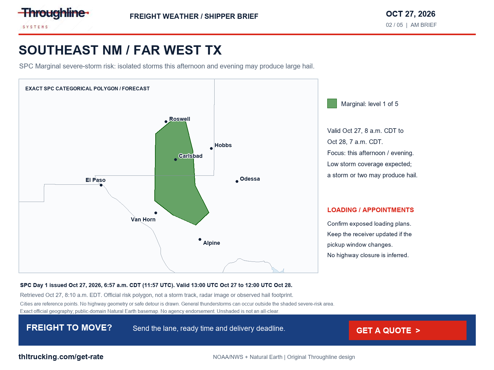
Sources: SPC Day 1 convective outlook; SPC exact Day 1 categorical polygons
Florida: wind ends on one clock; coastal flooding lasts longer
NWS wind advisories cover east-central Florida and metro/coastal Palm Beach, Broward and Miami-Dade through 8 p.m. EDT today. Forecast northeast winds are 15–25 mph with gusts up to 40 mph. The inland east-central advisory begins at 11 a.m.; the coastal advisories were already in effect at retrieval. Melbourne issued its notices at 1:28 a.m. EDT and Miami at 1:25 a.m.
WPC separately forecasts localized flash-flood potential in southeast Florida through 8 a.m. EDT October 28. Coastal Flood Warnings extend to 2 a.m. EDT October 30 along the named northeast/east-central Florida coastal zones and St. Johns River Basin, to 8 p.m. EDT October 28 for coastal Palm Beach/Broward/Miami-Dade, and to 5 a.m. EDT October 28 for the Keys. These warnings describe flooding and possible access impacts; they do not prove that a named highway, warehouse or port is closed.
Ask the receiver about its access road, yard and dock, and confirm how open-deck tarping or exposed loading will be handled. A separate FL511 construction alert, updated October 27 at 7:34 a.m. as displayed, lists the Edgewood Avenue/SR-111 railroad crossing near West Beaver Street/US-90 in Jacksonville closed until November 20. Treat that as a scheduled local-access restriction, not a weather closure.
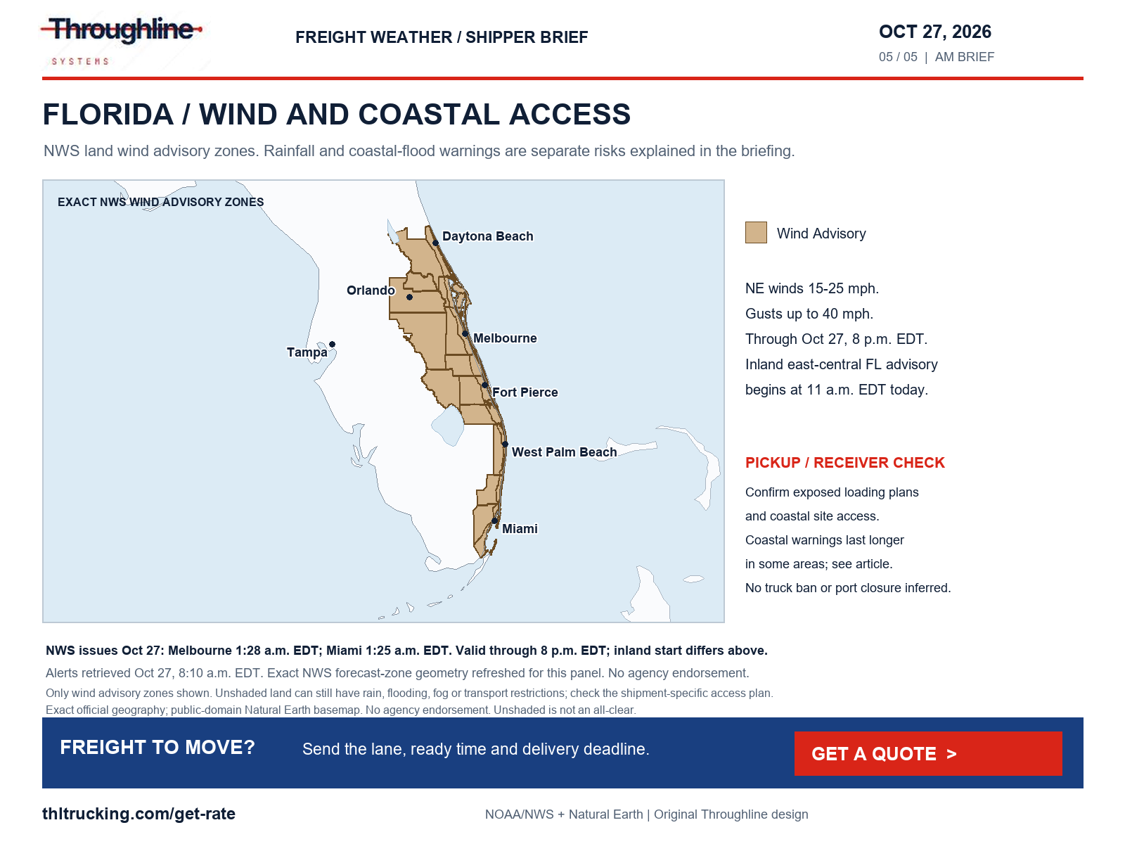
Sources: NWS Wind Advisory: Metro Palm Beach County; Metro Broward County; Metropolitan Miami Dade; Coastal Palm Beach County; Coastal Broward County; Coastal Miami Dade County; NWS Wind Advisory: Inland Volusia; Orange; Seminole; Osceola; Okeechobee; Inland Northern Brevard; Inland Indian River; Inland St. Lucie; Inland Martin; Inland Southern Brevard; NWS Wind Advisory: Coastal Volusia; Coastal Indian River; Coastal St. Lucie; Coastal Martin; Mainland Northern Brevard; Northern Brevard Barrier Islands; Mainland Southern Brevard; Southern Brevard Barrier Islands; WPC excessive-rainfall discussion; NWS Coastal Flood Warning: Coastal Volusia; Coastal Indian River; Coastal St. Lucie; Coastal Martin; Mainland Northern Brevard; Northern Brevard Barrier Islands; Mainland Southern Brevard; Southern Brevard Barrier Islands; NWS Coastal Flood Warning: Coastal Nassau; Coastal Duval; Coastal Flagler; Northeast Coastal St. Johns; Southeast Coastal St. Johns; NWS Coastal Flood Warning: Inland Flagler; Eastern Clay; Eastern Putnam; Trout River; South Central Duval; Western St. Johns; NWS Coastal Flood Warning: Coastal Palm Beach County; NWS Coastal Flood Warning: Coastal Broward County; Coastal Miami Dade County; NWS Coastal Flood Warning: Monroe Upper Keys; Monroe Middle Keys; Monroe Lower Keys; Florida 511 alerts
Morning fog and independent road incidents need their own checks
NWS dense-fog advisories cover selected areas of southeast Wyoming, northeast Colorado, southwest Nebraska, western Kansas, the Texas Panhandle and northeast New Mexico. The southeast Wyoming advisory through 9 a.m. MDT forecasts visibility below one-quarter mile; the Denver/northern Front Range advisory through 9 a.m. MDT forecasts one-quarter mile or less. Northeast New Mexico’s advisory, including the Raton Pass forecast zone, runs through 10 a.m. MDT with visibility one-half mile or less. Exact county/zone lists and issue times are in the linked alerts. These are forecasts, not observed visibility at every location.
The following selected transport reports were checked separately from the weather scan. A restriction can remain after the rain stops. Have the provider verify shipment-specific access and tell the receiver when the pickup or arrival window changes. Displayed agency update times below have no time-zone label unless stated.
A separate NWS Flood Warning, issued October 27 at 3:55 a.m. MDT and valid through noon MDT, reports moderate flooding along the San Juan River in southwestern San Juan County and eastern Kane County, Utah. Low-water crossings may be inundated. That river warning and the UDOT road closures are separate evidence; check both the public road and the site entrance.
| Location | Official report at review | Shipper action |
|---|---|---|
| Utah SR-162 at the US-191 junction in Bluff, MP 0–2 | UDOT lists both directions closed for flooding; update October 26, 4:36 p.m. This is narrower than the segment in yesterday’s briefing. | Recheck the exact current segment before release; a changed listing does not establish an unrestricted through route. |
| Utah SR-29, MP 9 at Joes Valley Reservoir | UDOT lists both directions closed for flooding; update October 26, 8:54 a.m. | Confirm local pickup/delivery access with the site. |
| Colorado US-160, MP 157–183, east of Pagosa Springs toward South Fork | CDOT’s rendered event lists both directions closed for safety concerns. Reviewed about 8:13 a.m. EDT; page said updated 35 minutes earlier. | Confirm the provider’s actual access plan; no reopening time is assumed. |
| North Carolina NC-12 near Rodanthe, Dare County | DriveNC still lists both directions closed for flooding; entry last updated October 23, 4:37 p.m. | Confirm island delivery access before committing the unloading crew. |
| Michigan eastbound I-94 after Haggerty, Wayne County | MDOT’s approximately 8:10 a.m. EDT snapshot reports a crash with only the left lane open; reported 7:43 a.m. as displayed. | Recheck the incident before fixing a Detroit-area appointment. |
| Wyoming I-80 eastbound MP 88.5–90 near Green River | WYDOT lists a 10-foot width restriction associated with bridge rehabilitation; road-condition row updated October 27, 6:02 a.m. | Have the provider check the complete equipment/load dimensions against the actual restriction. |
Sources: NWS Dense Fog Advisory: Kimball; Cheyenne; North Laramie Range; Central Laramie Range and Southwest Platte County; East Platte County; Goshen County; South Laramie Range; South Laramie Range Foothills; Central Laramie County; East Laramie County; NWS Dense Fog Advisory: Larimer County Below 6000 Feet/Northwest Weld County; Boulder And Jefferson Counties Below 6000 Feet/West Broomfield County; North Douglas County Below 6000 Feet/Denver/West Adams and Arapahoe Counties/East Broomfield County; Northeast Weld County; Central and South Weld County; Morgan County; Central and East Adams and Arapahoe Counties; NWS Dense Fog Advisory: Johnson and Bartlett Mesas Including Raton Pass; Far Northeast Highlands; Union County; NWS national active-alert snapshot; UDOT statewide alerts; CDOT: US-160 safety closure near Pagosa Springs–South Fork; NCDOT DriveNC special alerts; MDOT Mi Drive incidents; MDOT Mi Drive construction; WYDOT I-80 road report; NWS Flood Warning: Kane, UT; San Juan, UT
Rail handoffs and diesel: verify what has actually updated
BNSF’s customer library and incident page still return the October 25 initial Laguna, New Mexico, washout/derailment notice. It records a preliminary report on October 24 about 5:20 p.m. CDT and estimated track openings during October 25. Those estimates have passed, but this initial notice is not confirmation of restoration. For rail-dependent material, obtain the shipment’s actual release status before booking a transload pickup or committing a plant appointment.
EIA’s page retrieved October 27 at 8:10 a.m. EDT still lists October 19 as the latest weekly diesel observation, released October 20, with the next release scheduled October 27. U.S. on-highway diesel is $6.276 per gallon including taxes, up $0.097 from October 12. Midwest diesel is $6.352 per gallon and Gulf Coast diesel $5.903 for that same October 19 observation.
Do not treat the release calendar as a published new value. For a quote that crosses an index update, ask which observation week, fuel calculation and validity period apply. The EIA retail benchmark is not a truckload rate or a Throughline surcharge. If a rail-dependent production shortage needs a smaller urgent move, compare the minimum complete critical shipment with the existing replenishment plan; availability and timing still require confirmation.
Sources: BNSF Laguna washout/derailment initial report; EIA weekly on-highway diesel prices
Alaska, Hawaii, fire and the coverage limits
Alaska’s Western Brooks Range/Noatak Valley Winter Storm Warning, issued October 27 at 4 a.m. AKDT, covers 10 a.m. today through 4 p.m. AKDT October 29. It forecasts 6–18 inches total snow and gusts to 35 mph, with mostly rain below 800 feet. The Bering Strait Coast/Diomede/St. Lawrence Island High Wind Warning, issued at 3:35 a.m. AKDT, continues through 4 p.m. today with gusts to 60 mph. Confirm local receiving access; no Alaska highway restriction was independently established in this review.
Hawaii’s Flood Watch, issued October 26 at 3:30 p.m. HST, covers all main islands from Tuesday morning through late Wednesday night, ending 5 a.m. HST October 29. The greatest flood threat is focused on Oahu and Maui County. This is a watch for possible flash flooding and landslides, not a confirmed island-road closure. Separately, San Diego and Orange County coastal areas have a Coastal Flood Warning through 1 p.m. PDT October 29, focused on late-morning high tides; check low-lying receiver access.
The latest NIFC report returned was dated October 26 at 7:30 a.m. MDT. It continues to identify area, road and trail closures for the Austin fire southeast of Estacada, Oregon, and Sisi fire northwest of Stehekin, Washington. It does not establish a named freight-highway closure. The NWS snapshot returned no blizzard, dense-smoke, dust-storm or Red Flag warning; absence from that snapshot is not an all-clear. Smoke models, every local road and all terminal operations were not assessed.
The research ledger separately records high winds, severe storms/damaging wind/hail/tornado risk, snow/blowing snow/blizzard, freezing rain/sleet/ice, flooding, fog/smoke/dust, fire, crashes, construction, debris/landslides/washouts and bridge/road damage. Current route detail was not verified from the stale New Mexico download, the DriveTexas shell or the seasonal WSDOT pass fields. Forecast and road conditions can change after retrieval; recheck the responsible agency for the planned shipment.
Sources: NWS Winter Storm Warning: South Slopes of the Western Brooks Range; Noatak Valley; NWS High Wind Warning: Shishmaref; Bering Strait Coast; St Lawrence Island; NWS Flood Watch: Niihau; Kauai Southwest; Kauai Mountains; Waianae Coast; Oahu North Shore; Olomana; Central Oahu; Waianae Mountains; Lanai Mauka; Kahoolawe; Maui Windward West; Maui Leeward West; Haleakala Summit; Kona; Kohala; Big Island Interior; Big Island Summit; Kauai North; Kauai East; Kauai South; East Honolulu; Honolulu Metro; Ewa Plain; Koolau Windward; Koolau Leeward; Molokai Windward; Molokai Southeast; Molokai North; Molokai West; Molokai Leeward South; Lanai Windward; Lanai Leeward; Lanai South; Maui Central Valley North; Maui Central Valley South; Windward Haleakala; Kipahulu; South Maui/Upcountry; South Haleakala; Big Island South; Big Island Southeast; Big Island East; Big Island North; NWS Coastal Flood Warning: San Diego County Coastal Areas; Orange County Coastal; NIFC national incident situation report; NWS national active-alert snapshot; WPC heavy snow and icing discussion
Turn the briefing into a shipment-specific release decision
Send the origin and destination, true ready time, packed dimensions and weight, equipment needs, loading/unloading method and latest usable delivery time. For partial freight, confirm handling and timing compatibility; for FTL, confirm the offered truck and appointments. For open-deck lumber or machinery, name the required protection and exposed-site constraints. For enclosed equipment, verify dock access as well as weather protection.
If production needs only a small critical subset urgently, use the sprinter guide below to prepare the cargo and access details before requesting an assessment. A quote request does not reserve equipment or guarantee arrival. Keep one person responsible for confirming the release decision and communicating changes to the receiving team.
Sources and editorial notes
Original analysis by Throughline Systems. Source links may show newer releases after this article’s publication; the observation and issue dates below identify the material used. Agency citations do not imply endorsement.
- EIA weekly on-highway diesel prices
Page release date October 20, 2026; latest observation October 19; next release listed October 27. Dollars per gallon, including taxes. Retrieved October 27 at 8:10 a.m. EDT.
Accessed .
- WYDOT I-80 road report
Restriction rows updated October 27, 2026, 6:06 a.m. as displayed; time zone not labeled. Snapshot retrieved about 8:10 a.m. EDT.
Accessed .
- SPC Day 1 convective outlook
Issued October 27 at 6:57 a.m. CDT (11:57 UTC); valid October 27 13:00 UTC–October 28 12:00 UTC.
Accessed .
- SPC exact Day 1 categorical polygons
Issued October 27 at 11:57 UTC; valid October 27 13:00 UTC–October 28 12:00 UTC.
Accessed .
- WPC excessive-rainfall discussion
Issued October 27 at 4:13 a.m. EDT; Day 1 valid October 27 12:00 UTC–October 28 12:00 UTC. Later-day outlooks have separate periods.
Accessed .
- WPC exact Day 1 rainfall-risk polygons
Issued October 27 at 08:04 UTC; valid October 27 12:00 UTC–October 28 12:00 UTC.
Accessed .
- WPC heavy snow and icing discussion
Issued October 27 at 4:40 a.m. EDT; valid October 27 12:00 UTC–October 30 12:00 UTC.
Accessed .
- NWS national active-alert snapshot
Retrieved October 27 at 8:10 a.m. EDT; individual issue and validity times vary. National scan includes Alaska and Hawaii.
Accessed .
- WSDOT public mountain-pass reports and locations
Retrieved October 27; Stevens and Snoqualmie records returned seasonal reporting text and null report dates. Undated “No restrictions” fields are not accepted as a current all-clear.
Accessed .
- UDOT statewide alerts
Retrieved October 27 about 8:10 a.m. EDT. SR-29 updated October 26 at 8:54 a.m.; SR-162 updated October 26 at 4:36 p.m.; displayed times have no time-zone label.
Accessed .
- NCDOT DriveNC special alerts
Retrieved October 27; NC-12 entry last updated October 23 at 4:37 p.m. as displayed, without a time-zone label. Selected major alerts, not all road events.
Accessed .
- MDOT Mi Drive incidents
Retrieved October 27 about 8:10 a.m. EDT. Individual records display report time without a date/time-zone field.
Accessed .
- MDOT Mi Drive construction
504 returned records reviewed October 27; listed dates are construction schedules, not reopening guarantees.
Accessed .
- Florida 511 alerts
Retrieved October 27; Jacksonville crossing closure entry updated October 27 at 7:34 a.m. as displayed, without a time-zone label.
Accessed .
- BNSF Laguna washout/derailment initial report
Dated October 25, 2026; preliminary incident report October 24 about 5:20 p.m. CDT. No publication time displayed. Initial notice still returned at October 27 retrieval.
Accessed .
- NIFC national incident situation report
Latest PDF returned at retrieval: October 26, 2026, 7:30 a.m. MDT. National fire summary, not a live highway-status feed.
Accessed .
- CDOT: US-160 safety closure near Pagosa Springs–South Fork
Rendered event reviewed October 27 about 8:13 a.m. EDT; UI said “Updated 35 minutes ago.” US-160 mile points 157–183; no exact absolute update timestamp displayed.
Accessed .
- NWS High Wind Watch: North Snowy Range Foothills
Issued 2026-10-27T00:55:00-06:00; onset 2026-10-27T02:00:00-06:00; ends 2026-10-27T12:00:00-06:00 (source timestamps).
Accessed .
- NWS Winter Weather Advisory: Cascades of Whatcom and Skagit Counties; Cascades of Snohomish and Northern King Counties
Issued 2026-10-27T04:22:00-07:00; onset 2026-10-27T17:00:00-07:00; ends 2026-10-28T17:00:00-07:00 (source timestamps).
Accessed .
- NWS Winter Weather Advisory: Cascades of Southern King County
Issued 2026-10-27T04:22:00-07:00; onset 2026-10-27T17:00:00-07:00; ends 2026-10-28T17:00:00-07:00 (source timestamps).
Accessed .
- NWS Winter Weather Advisory: Cascades of Pierce and Lewis Counties
Issued 2026-10-27T04:22:00-07:00; onset 2026-10-27T17:00:00-07:00; ends 2026-10-28T17:00:00-07:00 (source timestamps).
Accessed .
- NWS Winter Weather Advisory: Upper Slopes of the Eastern Washington Cascades Crest
Issued 2026-10-26T22:39:00-07:00; onset 2026-10-27T17:00:00-07:00; ends 2026-10-28T17:00:00-07:00 (source timestamps).
Accessed .
- NWS Winter Weather Advisory: Western Chelan County; Western Okanogan County
Issued 2026-10-26T19:42:00-07:00; onset 2026-10-27T17:00:00-07:00; ends 2026-10-28T17:00:00-07:00 (source timestamps).
Accessed .
- NWS Wind Advisory: Metro Palm Beach County; Metro Broward County; Metropolitan Miami Dade; Coastal Palm Beach County; Coastal Broward County; Coastal Miami Dade County
Issued 2026-10-27T01:25:00-04:00; onset 2026-10-27T01:25:00-04:00; ends 2026-10-27T20:00:00-04:00 (source timestamps).
Accessed .
- NWS Wind Advisory: Inland Volusia; Orange; Seminole; Osceola; Okeechobee; Inland Northern Brevard; Inland Indian River; Inland St. Lucie; Inland Martin; Inland Southern Brevard
Issued 2026-10-27T01:28:00-04:00; onset 2026-10-27T11:00:00-04:00; ends 2026-10-27T20:00:00-04:00 (source timestamps).
Accessed .
- NWS Wind Advisory: Coastal Volusia; Coastal Indian River; Coastal St. Lucie; Coastal Martin; Mainland Northern Brevard; Northern Brevard Barrier Islands; Mainland Southern Brevard; Southern Brevard Barrier Islands
Issued 2026-10-27T01:28:00-04:00; onset 2026-10-27T01:28:00-04:00; ends 2026-10-27T20:00:00-04:00 (source timestamps).
Accessed .
- NWS Dense Fog Advisory: Kimball; Cheyenne; North Laramie Range; Central Laramie Range and Southwest Platte County; East Platte County; Goshen County; South Laramie Range; South Laramie Range Foothills; Central Laramie County; East Laramie County
Issued 2026-10-27T00:55:00-06:00; onset 2026-10-27T00:55:00-06:00; ends 2026-10-27T09:00:00-06:00 (source timestamps).
Accessed .
- NWS Dense Fog Advisory: Larimer County Below 6000 Feet/Northwest Weld County; Boulder And Jefferson Counties Below 6000 Feet/West Broomfield County; North Douglas County Below 6000 Feet/Denver/West Adams and Arapahoe Counties/East Broomfield County; Northeast Weld County; Central and South Weld County; Morgan County; Central and East Adams and Arapahoe Counties
Issued 2026-10-27T04:09:00-06:00; onset 2026-10-27T04:09:00-06:00; ends 2026-10-27T09:00:00-06:00 (source timestamps).
Accessed .
- NWS Dense Fog Advisory: Johnson and Bartlett Mesas Including Raton Pass; Far Northeast Highlands; Union County
Issued 2026-10-27T04:44:00-06:00; onset 2026-10-27T04:44:00-06:00; ends 2026-10-27T10:00:00-06:00 (source timestamps).
Accessed .
- NWS Flood Warning: Kane, UT; San Juan, UT
Issued 2026-10-27T03:55:00-06:00; onset 2026-10-27T03:55:00-06:00; ends 2026-10-27T12:00:00-06:00 (source timestamps).
Accessed .
- NWS Coastal Flood Warning: San Diego County Coastal Areas; Orange County Coastal
Issued 2026-10-27T02:02:00-07:00; onset 2026-10-27T02:02:00-07:00; ends 2026-10-29T13:00:00-07:00 (source timestamps).
Accessed .
- NWS Coastal Flood Warning: Coastal Volusia; Coastal Indian River; Coastal St. Lucie; Coastal Martin; Mainland Northern Brevard; Northern Brevard Barrier Islands; Mainland Southern Brevard; Southern Brevard Barrier Islands
Issued 2026-10-27T02:26:00-04:00; onset 2026-10-27T02:26:00-04:00; ends 2026-10-30T02:00:00-04:00 (source timestamps).
Accessed .
- NWS Coastal Flood Warning: Coastal Nassau; Coastal Duval; Coastal Flagler; Northeast Coastal St. Johns; Southeast Coastal St. Johns
Issued 2026-10-27T03:33:00-04:00; onset 2026-10-27T03:33:00-04:00; ends 2026-10-30T02:00:00-04:00 (source timestamps).
Accessed .
- NWS Coastal Flood Warning: Inland Flagler; Eastern Clay; Eastern Putnam; Trout River; South Central Duval; Western St. Johns
Issued 2026-10-27T03:33:00-04:00; onset 2026-10-27T03:33:00-04:00; ends 2026-10-30T02:00:00-04:00 (source timestamps).
Accessed .
- NWS Coastal Flood Warning: Coastal Palm Beach County
Issued 2026-10-27T01:22:00-04:00; onset 2026-10-27T01:22:00-04:00; ends 2026-10-28T20:00:00-04:00 (source timestamps).
Accessed .
- NWS Coastal Flood Warning: Coastal Broward County; Coastal Miami Dade County
Issued 2026-10-27T01:22:00-04:00; onset 2026-10-27T01:22:00-04:00; ends 2026-10-28T20:00:00-04:00 (source timestamps).
Accessed .
- NWS Coastal Flood Warning: Monroe Upper Keys; Monroe Middle Keys; Monroe Lower Keys
Issued 2026-10-27T04:00:00-04:00; onset 2026-10-27T04:00:00-04:00; ends 2026-10-28T05:00:00-04:00 (source timestamps).
Accessed .
- NWS Winter Storm Warning: South Slopes of the Western Brooks Range; Noatak Valley
Issued 2026-10-27T04:00:00-08:00; onset 2026-10-27T10:00:00-08:00; ends 2026-10-29T16:00:00-08:00 (source timestamps).
Accessed .
- NWS High Wind Warning: Shishmaref; Bering Strait Coast; St Lawrence Island
Issued 2026-10-27T03:35:00-08:00; onset 2026-10-27T03:35:00-08:00; ends 2026-10-27T16:00:00-08:00 (source timestamps).
Accessed .
- NWS Flood Watch: Niihau; Kauai Southwest; Kauai Mountains; Waianae Coast; Oahu North Shore; Olomana; Central Oahu; Waianae Mountains; Lanai Mauka; Kahoolawe; Maui Windward West; Maui Leeward West; Haleakala Summit; Kona; Kohala; Big Island Interior; Big Island Summit; Kauai North; Kauai East; Kauai South; East Honolulu; Honolulu Metro; Ewa Plain; Koolau Windward; Koolau Leeward; Molokai Windward; Molokai Southeast; Molokai North; Molokai West; Molokai Leeward South; Lanai Windward; Lanai Leeward; Lanai South; Maui Central Valley North; Maui Central Valley South; Windward Haleakala; Kipahulu; South Maui/Upcountry; South Haleakala; Big Island South; Big Island Southeast; Big Island East; Big Island North
Issued 2026-10-26T15:30:00-10:00; onset 2026-10-27T06:00:00-10:00; ends 2026-10-29T05:00:00-10:00 (source timestamps).
Accessed .