October 28 logistics briefing: new diesel week, Midwest storms and pass restrictions
Wednesday shipper briefing: October 26 diesel data, Minnesota/Wisconsin storm risk, Cascades oversize prohibitions, Wyoming I-80 wind limits and Southwest rail recovery.
By Throughline Systems · · 13 min read
What matters for your next load
- EIA’s new October 26 observation is $6.352 per gallon nationally, up 7.6 cents from October 19; it is weekly data.
- Check actual vehicle eligibility: WSDOT lists oversize prohibitions at Stevens and Snoqualmie; WYDOT restricts high-profile vehicles under 40,000 GVW from Rawlins to Laramie.
- Upper Midwest severe storms are forecast today; Southwest rail recovery and tomorrow’s Texas rainfall risk need separate shipment and receiving checks.
Today’s release decision: check vehicle eligibility, then the appointment
Research snapshot: October 28, 2026, about 8 a.m. EDT, with pass reports checked afterward. Today’s most actionable transport constraints include Wyoming’s weight-based high-profile vehicle restriction and Washington’s oversize prohibitions. Separately, severe storms are forecast for parts of Minnesota and Wisconsin, and Southwest rail recovery remains a shipment-tracing issue. These signals call for lane-specific decisions, not a nationwide stop or a guaranteed detour.
The national map combines two different forecast products with separate legends: SPC severe-storm risk and WPC excessive-rainfall risk. Wind, winter conditions, fog, coastal flooding, fire and confirmed road incidents are assessed below. Alaska and Hawaii insets show geography only because these CONUS layers do not cover them; their hazards are included in the text.
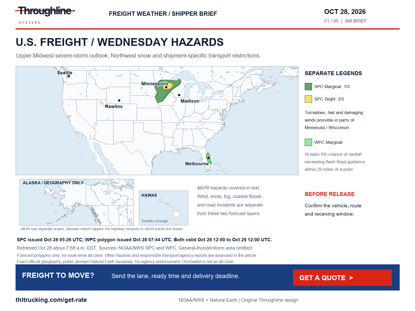
Sources: SPC Day 1 severe-storm outlook; SPC exact categorical polygons; WPC excessive-rainfall discussion; WPC Day 1 exact rainfall-risk polygons
New diesel week: use October 26, not a daily price
EIA’s October 27 release reports U.S. on-highway diesel at $6.352 per gallon for October 26, up $0.076 from $6.276 on October 19. Prices include taxes. This is the latest weekly observation returned at retrieval, not an October 28 daily price; EIA lists November 3 as the next release date.
For an FTL or partial quote, confirm which index, base, lag and formula govern any fuel component. A national pump average does not establish a lane rate or an automatic change to an agreed all-in price. Regional movement differs: the Midwest rose while the West Coast fell.
| EIA geography | Oct 26 ($/gal) | Change from Oct 19 ($/gal) |
|---|---|---|
| U.S. | 6.352 | +0.076 |
| East Coast | 6.079 | +0.095 |
| Midwest | 6.480 | +0.128 |
| Gulf Coast | 5.951 | +0.048 |
| Rocky Mountain | 6.521 | +0.099 |
| West Coast | 7.329 | −0.065 |
Sources: EIA weekly on-highway diesel
Minnesota and Wisconsin: prepare for a conditional afternoon storm window
SPC’s 12:26 a.m. CDT outlook places parts of east-central Minnesota and west-central Wisconsin in Slight risk, level 2 of 5, surrounded by a broader Marginal area. The outlook is valid 7 a.m. CDT October 28–7 a.m. CDT October 29. A few severe storms may develop near peak heating, with tornado potential, isolated large hail and damaging winds. Instability is a limiting factor; the discussion describes the stronger scenario as conditional.
Manufacturers and distributors with exposed loading in that area should agree on a pause-and-resume contact and tell receivers how an altered pickup time will be communicated. This forecast is not evidence of an observed tornado or a highway closure. Wisconsin’s special-alert page returned no alerts in that limited list. Minnesota’s browser road-report list encountered a service connection error, so this review could not verify its current incident detail. Check the actual route with the responsible agency before release.
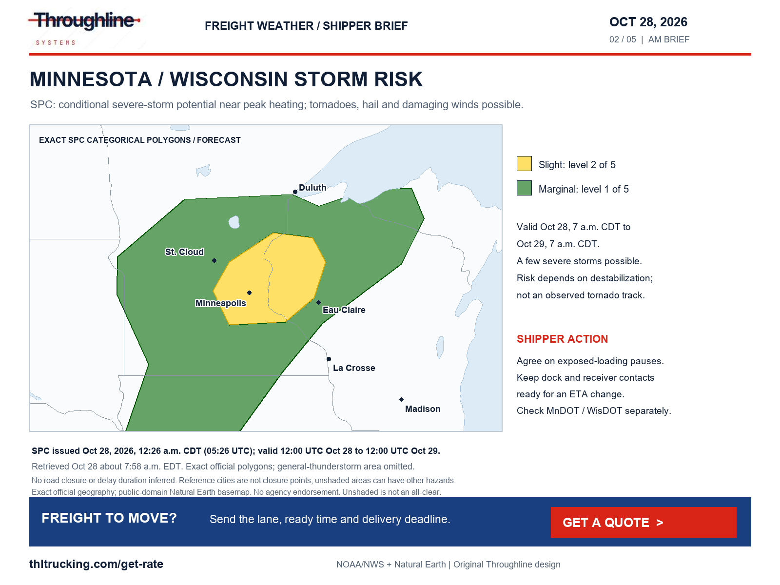
Sources: SPC Day 1 severe-storm outlook; SPC exact categorical polygons; MnDOT 511; WisDOT 511 special alerts
Cascades: snow forecasts and confirmed oversize prohibitions are separate facts
WSDOT’s rendered Stevens Pass/US-2 and Snoqualmie Pass/I-90 reports both show oversize vehicles prohibited in both directions, with traction tires advised. Stevens reports mostly bare/wet pavement with snow and slush in places; Snoqualmie reports bare/wet pavement with slush in places. The displayed October 28 update clocks are 4:34 a.m. and 7:15 a.m. respectively, without time-zone labels. These are transport-agency restrictions, not inferences from NWS shading. They do not establish a complete closure or a chain requirement.
NWS west-slope advisories issued at 1:53 a.m. PDT run until 5 p.m. PDT today. They forecast additional snow up to 2 inches in the Whatcom/Skagit, Snohomish/northern King and southern King mountain zones, and up to 6 inches in Pierce/Lewis; amounts are heaviest above 4,000 feet. Snoqualmie may mix rain and snow, with about an inch possible. These are additional amounts, not the older full-event totals.
East-side notices have different accumulation bases: western Chelan/Okanogan’s October 27, 9:31 p.m. PDT advisory forecasts 2–5 inches above 3,000 feet and 5–9 inches near the crest, including Stevens and Washington passes. The upper eastern crest’s 10:14 p.m. PDT notice gives 3–7 inches above 4,000 feet and gusts to 35 mph. Both end at 5 p.m. PDT today. Do not add those full-period totals to the west-slope additional amounts.
Before releasing machinery or long building materials, check whether the permitted dimensions are eligible for the chosen crossing. For other open-deck and enclosed shipments, confirm current pass status, freight protection and the receiver’s unloading window. WPC also forecasts northern Idaho/northwest Montana mountain snow today; the East Glacier Park advisory covers 3 p.m. MDT today–6 a.m. Thursday, with 2–4 inches at Marias Pass and 4–8 inches above 6,000 feet. No Montana chain requirement or closure is established here.
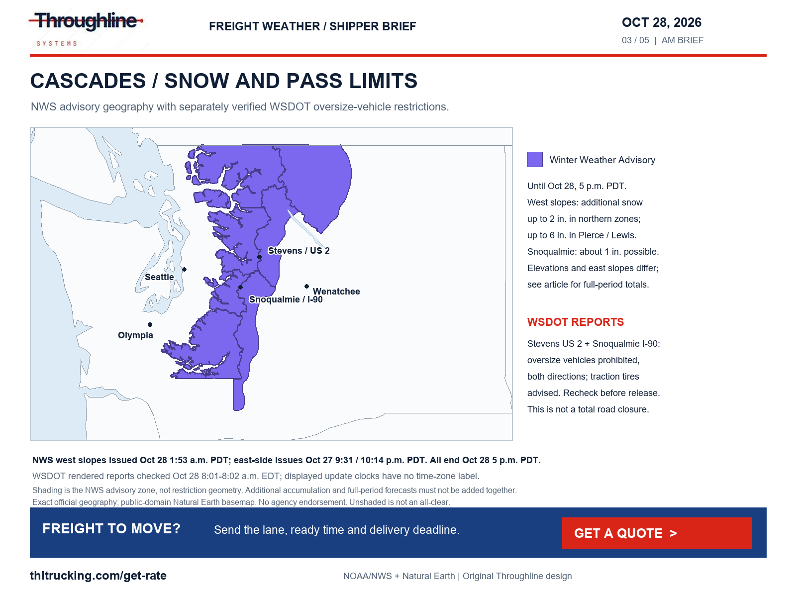
Sources: WSDOT Stevens Pass report; WSDOT Snoqualmie Pass report; NWS Winter Weather Advisory: Cascades of Whatcom and Skagit Counties; Cascades of Snohomish and Northern King Counties; NWS Winter Weather Advisory: Cascades of Southern King County; NWS Winter Weather Advisory: Cascades of Pierce and Lewis Counties; NWS Winter Weather Advisory: Upper Slopes of the Eastern Washington Cascades Crest; NWS Winter Weather Advisory: Western Chelan County; Western Okanogan County; NWS Winter Weather Advisory: East Glacier Park Region; WPC heavy snow and icing discussion
Wyoming I-80: match the actual truck to the restriction
WYDOT’s report retrieved about 7:59 a.m. EDT lists I-80 segments from Rawlins through Walcott Junction, Elk Mountain, Arlington and Quealy Dome to Laramie closed to all high-profile vehicles under 40,000 GVW because of gusting winds. Those rows show October 28, 4:50 a.m. updates without a time-zone label. The current threshold is material to the release decision; yesterday’s threshold should not be reused.
Ask the transport provider to verify the actual vehicle against the latest restriction before dispatch, then update the receiver if eligibility changes the plan. Separately, WYDOT still lists the Higley Boulevard overpass at Exit 214 near Rawlins closed because of bridge damage. Westbound I-80 mileposts 48–48.5 have a 12-foot width restriction for emergency bridge-deck repairs. These separate infrastructure issues can matter even when a shipment is outside the wind-restricted vehicle class.
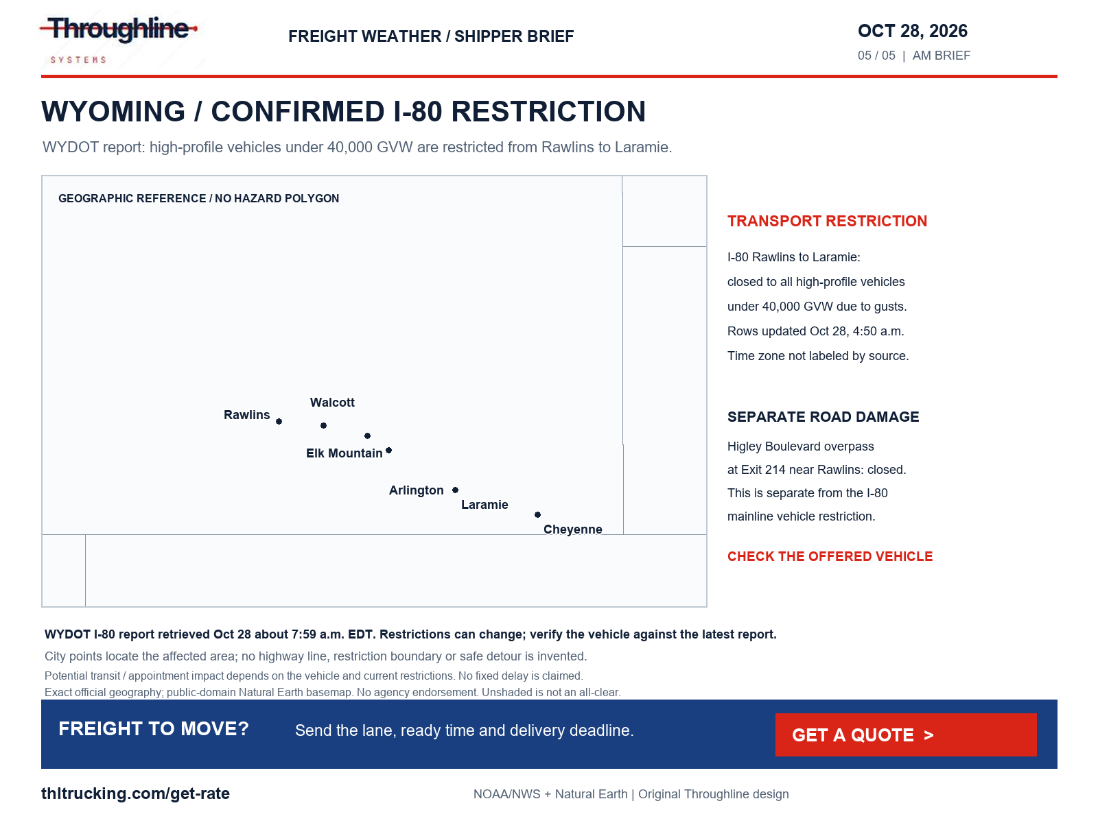
Sources: WYDOT I-80 report
Southwest rail recovery: verify freight availability before booking the truck leg
BNSF’s newer October 26 advisory describes both Gallup Subdivision main tracks near Laguna, New Mexico, taken out of service after flooding, and the El Paso Subdivision out of service between Sabinal and La Joya south of Belen. The notice expected one Gallup track back that afternoon with single-track operation through roughly 12 miles of repair area; it did not provide restoration times for the second track or El Paso line. Those were notice-date estimates, not confirmed October 28 reopening evidence.
At this morning’s retrieval, that remained the newest relevant advisory found in BNSF’s notification index. It warns of residual delays and unusual routings while recovery progresses. A shipper waiting on rail-fed lumber, components or distributor replenishment should obtain a current shipment trace and terminal release status before reserving the truck pickup and receiver slot. Do not interpret a projected track reopening as proof that a particular shipment is available.
Rain and coastal access: Florida today, Texas tomorrow
WPC’s 4:22 a.m. EDT discussion assigns east-central Florida a Marginal excessive-rainfall risk for 8 a.m. EDT today–8 a.m. Thursday, with isolated flash flooding possible. Coastal hazards run on other clocks: Broward/Miami-Dade and Palm Beach warnings extend through 8 p.m. EDT today, followed by advisories through Thursday evening; the Keys warning lasts to 5 a.m. Thursday. East-central and northeast Florida and coastal Glynn/Camden, Georgia, have coastal-flood warnings through 2 a.m. EDT Friday. These warnings describe potential access impacts, not a verified closure of every coastal road or port.
For Thursday pickups, WPC’s Day 2 outlook has Slight excessive-rainfall risk across parts of west and central Texas, valid October 29 7 a.m. CDT–October 30 7 a.m. CDT. Confirm low-lying yard access, freight protection and a receiver contingency before loading. DriveTexas did not expose current event detail in the retrieved page, so no Texas route closure or usable alternate is asserted here.
Orange County and San Diego County coastal areas also have a coastal-flood warning through 1 p.m. PDT Thursday, focused on late-morning high tides. A coastal delivery should include a site-access check as well as the highway check. Forecast runoff or tidal flooding does not, by itself, establish terminal shutdowns.
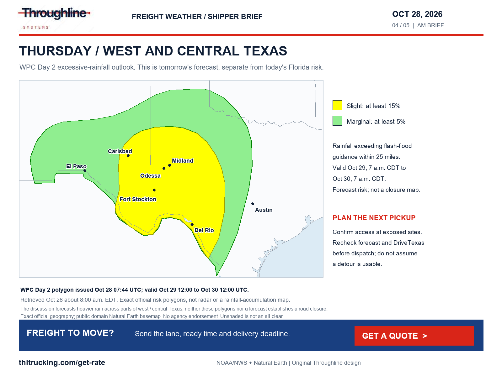
Sources: WPC excessive-rainfall discussion; WPC Day 1 exact rainfall-risk polygons; WPC Day 2 exact rainfall-risk polygons; NWS Coastal Flood Warning: Coastal Broward County; Coastal Miami Dade County; NWS Coastal Flood Warning: Monroe Upper Keys; Monroe Middle Keys; Monroe Lower Keys; NWS Coastal Flood Warning: Coastal Volusia; Coastal Indian River; Coastal St. Lucie; Coastal Martin; Mainland Northern Brevard; Northern Brevard Barrier Islands; Mainland Southern Brevard; Southern Brevard Barrier Islands; NWS Coastal Flood Warning: Coastal Nassau; Coastal Duval; Coastal Flagler; Northeast Coastal St. Johns; Southeast Coastal St. Johns; NWS Coastal Flood Warning: Coastal Glynn; Coastal Camden; NWS Coastal Flood Warning: San Diego County Coastal Areas; Orange County Coastal; NWS Coastal Flood Warning: Coastal Palm Beach County
Fog, crashes and long-running closures: check them even without a storm
Morning dense-fog advisories include parts of eastern Colorado, western Kansas and Nebraska through 10 a.m. MDT/11 a.m. CDT, with visibility commonly one-quarter to one-half mile or less. Burleigh/Emmons and eastern Morton/Sioux in North Dakota run through 10 a.m. CDT; Leon/Milam/Robertson in Texas through 11 a.m. CDT; Guadalupe/De Baca in New Mexico through 9 a.m. MDT. These are localized advisories, not statewide visibility statements. Build the pickup communication plan around an updated ETA rather than a fixed promised delay.
Independent MDOT incidents at retrieval include westbound US-10 at Garfield Road/Exit 132 in Bay County closed for a crash, westbound I-96 at Pleasant Valley Road/Exit 150 with the left two lanes blocked, and eastbound M-6 after 8th Avenue/Exit 1 with the left lane blocked. The rows display report clocks of 6:07 a.m., 3:46 a.m. and 7:24 a.m. respectively without date/time-zone fields. Recheck these short-lived incidents before using them for dispatch; cleared I-75 and US-131 entries were not treated as active closures.
UDOT continues to list both directions of SR-29 at milepost 9 near Joes Valley Reservoir and SR-162 mileposts 0–2 at the US-191 junction in Bluff closed for flooding. DriveNC’s selected-alert page retains NC-12 near Rodanthe closed in both directions. Florida 511 lists the Edgewood Avenue/SR-111 railroad crossing near West Beaver Street/US-90 in Jacksonville closed for scheduled construction through November 20. These local restrictions require checking the actual facility approach; no freight-safe alternate is supplied here.
Sources: NWS Dense Fog Advisory: Yuma County; Kit Carson County; Cheyenne County; Cheyenne; Rawlins; Decatur; Norton; Sherman; Thomas; Sheridan; Graham; Wallace; Logan; Gove; Dundy; Hitchcock; Red Willow; NWS Dense Fog Advisory: Garden; Grant; Hooker; Thomas; Blaine; Loup; Garfield; Arthur; McPherson; Logan; Custer; Deuel; Keith; Perkins; Lincoln; Chase; Hayes; Frontier; NWS Dense Fog Advisory: Burleigh; Emmons; Eastern Morton; Eastern Sioux; NWS Dense Fog Advisory: Leon; Milam; Robertson; NWS Dense Fog Advisory: Guadalupe County; De Baca County; MDOT Mi Drive incidents; MDOT construction list; UDOT statewide alerts; NCDOT DriveNC special alerts; Florida 511 alerts
Alaska, Hawaii, smoke and ice: coverage beyond the CONUS outlook
Alaska’s western Brooks Range/Red Dog warning, issued at 3:01 a.m. AKDT today, runs to 4 p.m. Thursday: forecast totals are 6–12 inches near Red Dog Mine and 12–18 inches in the western Brooks Range, with gusts to 35 mph and blowing-snow visibility impacts. A separate central Brooks south-slope watch covers Thursday 7 p.m.–Saturday 7 a.m. AKDT for possible 8–12 inches. The Alaska Range/Windy Pass advisory covers today 7 a.m.–Thursday 7 a.m. AKDT for south winds 30–45 mph and gusts to 65 mph; the Kuskokwim Delta coast/Nunivak advisory runs to 10 a.m. today with gusts to 55 mph. These are forecasts, not verified truck restrictions.
Anchorage/Eagle River/Turnagain Arm and Kenai Peninsula fog advisories run to 10 a.m. AKDT today, with quarter-mile-or-less visibility and possible frost or slick surfaces near freezing. Hawaii’s all-main-islands flood watch runs to 5 a.m. HST Thursday; Big Island summit high-wind warning runs to noon HST today for southwest winds 30–40 mph and gusts to 80 mph. The summit wind forecast must not be generalized to island ports. Confirm local loading and last-mile access with the facility and transport authority.
Marion County, Indiana, has an air-quality advisory through 10 a.m. EDT today for fine particulate pollution; wildfire smoke is identified in the notices. That is a worker-exposure consideration for outdoor loading, not evidence of a closed highway. The latest NIFC report returned was October 27 at 7:30 a.m. MDT and lists area/road/trail closures at selected Northwest fires without establishing a specific freight-highway closure in this review.
WPC puts significant CONUS icing probability below 10% during its October 28–31 discussion period; that does not rule out local slick roads. The national NWS snapshot was also checked for freezing rain, sleet, blizzard, dust and smoke warnings. No dedicated warning for those categories was found in that snapshot, while snow, fog, wind and air-quality hazards were present. Local non-alerted conditions, every road and every terminal were not assessed.
Sources: NWS Winter Storm Warning: South Slopes of the Western Brooks Range; Noatak Valley; NWS Winter Storm Watch: South Slopes Of The Central Brooks Range; NWS Wind Advisory: Northern Denali Borough; Eastern Alaska Range North of Trims Camp; NWS Wind Advisory: Kuskokwim Delta Coast and Nunivak Island; NWS Dense Fog Advisory: Anchorage; Anchorage Hillside / Eagle River; East Turnagain Arm; Portage; NWS Flood Watch: Niihau; Kauai Southwest; Kauai Mountains; Waianae Coast; Oahu North Shore; Olomana; Central Oahu; Waianae Mountains; Lanai Mauka; Kahoolawe; Maui Windward West; Maui Leeward West; Haleakala Summit; Kona; Kohala; Big Island Interior; Big Island Summit; Kauai North; Kauai East; Kauai South; East Honolulu; Honolulu Metro; Ewa Plain; Koolau Windward; Koolau Leeward; Molokai Windward; Molokai Southeast; Molokai North; Molokai West; Molokai Leeward South; Lanai Windward; Lanai Leeward; Lanai South; Maui Central Valley North; Maui Central Valley South; Windward Haleakala; Kipahulu; South Maui/Upcountry; South Haleakala; Big Island South; Big Island Southeast; Big Island East; Big Island North; NWS High Wind Warning: Big Island Summit; NWS Air Quality Alert: Marion; NIFC national incident situation report; WPC heavy snow and icing discussion; NWS national active-alert snapshot; NWS Dense Fog Advisory: SW Kenai Peninsula; NW Kenai Peninsula; Skilak Lake
What to send with today’s quote request
Provide the lane, actual freight-ready time, packed dimensions and weight, equipment requirement, loading/unloading method and latest usable delivery time. For open-deck machinery or lumber, identify oversize dimensions, protection needs and exposed handling. For enclosed FTL or partial freight, confirm dock access and receiver acceptance; a dry trailer does not solve a road restriction.
If only a small production-critical subset needs to arrive urgently, prepare its actual packed size and handling details for a sprinter assessment. Ask for a shipment-specific plan rather than assuming a smaller vehicle avoids the hazard. A quote request does not reserve equipment or guarantee arrival. The contextual Get a quote action below opens the public request flow.
Sources and editorial notes
Original analysis by Throughline Systems. Source links may show newer releases after this article’s publication; the observation and issue dates below identify the material used. Agency citations do not imply endorsement.
- EIA weekly on-highway diesel
Released October 27, 2026; latest observation October 26. Dollars per gallon including taxes. Next release listed November 3; no publication clock shown.
Accessed .
- SPC Day 1 severe-storm outlook
Issued October 28 at 12:26 a.m. CDT (05:26 UTC); valid October 28 12:00 UTC–October 29 12:00 UTC.
Accessed .
- SPC exact categorical polygons
Issued October 28 05:26 UTC; valid October 28 12:00 UTC–October 29 12:00 UTC.
Accessed .
- WPC excessive-rainfall discussion
Issued October 28 4:22 a.m. EDT. Day 1: October 28 12:00 UTC–October 29 12:00 UTC; Day 2: October 29 12:00 UTC–October 30 12:00 UTC.
Accessed .
- WPC Day 1 exact rainfall-risk polygons
Issued October 28 07:44 UTC; valid October 28 12:00 UTC–October 29 12:00 UTC.
Accessed .
- WPC Day 2 exact rainfall-risk polygons
Issued October 28 07:44 UTC; valid October 29 12:00 UTC–October 30 12:00 UTC.
Accessed .
- WPC heavy snow and icing discussion
Issued October 28 4:46 a.m. EDT; valid October 28 12:00 UTC–October 31 12:00 UTC.
Accessed .
- NWS national active-alert snapshot
Retrieved October 28 at 7:58 a.m. EDT. Individual land/marine alerts have their own issue and validity periods; this is not a complete road-status feed.
Accessed .
- WYDOT I-80 report
Retrieved October 28 about 7:59 a.m. EDT. Wind-restriction rows updated October 28 4:50 a.m. as displayed; source does not label the time zone.
Accessed .
- UDOT statewide alerts
Retrieved October 28 about 7:59 a.m. EDT. SR-29 row updated October 26 8:54 a.m.; SR-162 October 26 4:36 p.m. Displayed clocks lack time-zone labels.
Accessed .
- NCDOT DriveNC special alerts
Retrieved October 28 about 7:59 a.m. EDT; NC-12 row updated October 23 4:37 p.m., time zone not displayed. This page covers selected major alerts only.
Accessed .
- Florida 511 alerts
Retrieved October 28 about 7:59 a.m. EDT; Jacksonville construction row updated October 28 6:44 a.m., time zone not displayed.
Accessed .
- MDOT Mi Drive incidents
Snapshot retrieved October 28 about 7:59 a.m. EDT. Incident rows display report clocks but no date/time-zone field; cleared events are distinguished.
Accessed .
- MDOT construction list
Retrieved October 28. Scheduled construction dates are not guarantees of reopening.
Accessed .
- MnDOT 511
Retrieved October 28. Browser road-report list could not load reliable event records and showed a reCAPTCHA-service connection error; coverage gap, not an all-clear.
Accessed .
- WisDOT 511 special alerts
Retrieved October 28 about 8:00 a.m. EDT. Special-alert list reported no alerts; ordinary traffic events and every corridor were not assessed.
Accessed .
- BNSF Southwest flood-recovery advisory
Dated October 26, 2026; no release clock shown. Retrieved October 28 about 8:00 a.m. EDT. Restoration estimates belong to the notice date, not retrieval date.
Accessed .
- NIFC national incident situation report
Latest PDF returned: October 27, 2026, 7:30 a.m. MDT. National fire summary, not a live highway closure feed.
Accessed .
- WSDOT Stevens Pass report
Rendered October 28 report: 4:34 a.m. update as displayed; no time-zone label. Browser-verified oversize prohibition and traction-tire advisory in both directions.
Accessed .
- WSDOT Snoqualmie Pass report
Rendered October 28 report: 7:15 a.m. update as displayed; no time-zone label. Browser-verified oversize prohibition and traction-tire advisory in both directions.
Accessed .
- NWS Winter Weather Advisory: Cascades of Whatcom and Skagit Counties; Cascades of Snohomish and Northern King Counties
Issued 2026-10-28T01:53:00-07:00; onset 2026-10-28T01:53:00-07:00; ends 2026-10-28T17:00:00-07:00 (source timestamps; any shorter text validity controls).
Accessed .
- NWS Winter Weather Advisory: Cascades of Southern King County
Issued 2026-10-28T01:53:00-07:00; onset 2026-10-28T01:53:00-07:00; ends 2026-10-28T17:00:00-07:00 (source timestamps; any shorter text validity controls).
Accessed .
- NWS Winter Weather Advisory: Cascades of Pierce and Lewis Counties
Issued 2026-10-28T01:53:00-07:00; onset 2026-10-28T01:53:00-07:00; ends 2026-10-28T17:00:00-07:00 (source timestamps; any shorter text validity controls).
Accessed .
- NWS Winter Weather Advisory: Upper Slopes of the Eastern Washington Cascades Crest
Issued 2026-10-27T22:14:00-07:00; onset 2026-10-27T22:14:00-07:00; ends 2026-10-28T17:00:00-07:00 (source timestamps; any shorter text validity controls).
Accessed .
- NWS Winter Weather Advisory: Western Chelan County; Western Okanogan County
Issued 2026-10-27T21:31:00-07:00; onset 2026-10-27T21:31:00-07:00; ends 2026-10-28T17:00:00-07:00 (source timestamps; any shorter text validity controls).
Accessed .
- NWS Winter Weather Advisory: East Glacier Park Region
Issued 2026-10-27T23:45:00-06:00; onset 2026-10-28T15:00:00-06:00; ends 2026-10-29T06:00:00-06:00 (source timestamps; any shorter text validity controls).
Accessed .
- NWS Dense Fog Advisory: Yuma County; Kit Carson County; Cheyenne County; Cheyenne; Rawlins; Decatur; Norton; Sherman; Thomas; Sheridan; Graham; Wallace; Logan; Gove; Dundy; Hitchcock; Red Willow
Issued 2026-10-28T04:54:00-06:00; onset 2026-10-28T04:54:00-06:00; ends 2026-10-28T10:00:00-06:00 (source timestamps; any shorter text validity controls).
Accessed .
- NWS Dense Fog Advisory: Garden; Grant; Hooker; Thomas; Blaine; Loup; Garfield; Arthur; McPherson; Logan; Custer; Deuel; Keith; Perkins; Lincoln; Chase; Hayes; Frontier
Issued 2026-10-28T03:41:00-05:00; onset 2026-10-28T03:41:00-05:00; ends 2026-10-28T11:00:00-05:00 (source timestamps; any shorter text validity controls).
Accessed .
- NWS Dense Fog Advisory: Burleigh; Emmons; Eastern Morton; Eastern Sioux
Issued 2026-10-28T05:51:00-05:00; onset 2026-10-28T05:51:00-05:00; ends 2026-10-28T10:00:00-05:00 (source timestamps; any shorter text validity controls).
Accessed .
- NWS Dense Fog Advisory: Leon; Milam; Robertson
Issued 2026-10-28T06:15:00-05:00; onset 2026-10-28T07:00:00-05:00; ends 2026-10-28T11:00:00-05:00 (source timestamps; any shorter text validity controls).
Accessed .
- NWS Dense Fog Advisory: Guadalupe County; De Baca County
Issued 2026-10-28T04:20:00-06:00; onset 2026-10-28T04:20:00-06:00; ends 2026-10-28T09:00:00-06:00 (source timestamps; any shorter text validity controls).
Accessed .
- NWS Air Quality Alert: Marion
Issued 2026-10-27T11:35:00-04:00; notice valid October 27 6 p.m.–October 28 10 a.m. EDT.
Accessed .
- NWS Coastal Flood Warning: Coastal Broward County; Coastal Miami Dade County
Issued 2026-10-28T05:39:00-04:00; onset 2026-10-28T05:39:00-04:00; ends 2026-10-28T20:00:00-04:00 (source timestamps; any shorter text validity controls).
Accessed .
- NWS Coastal Flood Warning: Monroe Upper Keys; Monroe Middle Keys; Monroe Lower Keys
Issued 2026-10-28T04:00:00-04:00; onset 2026-10-28T04:00:00-04:00; ends 2026-10-29T05:00:00-04:00 (source timestamps; any shorter text validity controls).
Accessed .
- NWS Coastal Flood Warning: Coastal Volusia; Coastal Indian River; Coastal St. Lucie; Coastal Martin; Mainland Northern Brevard; Northern Brevard Barrier Islands; Mainland Southern Brevard; Southern Brevard Barrier Islands
Issued 2026-10-28T02:40:00-04:00; onset 2026-10-28T02:40:00-04:00; ends 2026-10-30T02:00:00-04:00 (source timestamps; any shorter text validity controls).
Accessed .
- NWS Coastal Flood Warning: Coastal Nassau; Coastal Duval; Coastal Flagler; Northeast Coastal St. Johns; Southeast Coastal St. Johns
Issued 2026-10-28T02:48:00-04:00; onset 2026-10-28T02:48:00-04:00; ends 2026-10-30T02:00:00-04:00 (source timestamps; any shorter text validity controls).
Accessed .
- NWS Coastal Flood Warning: Coastal Glynn; Coastal Camden
Issued 2026-10-28T02:48:00-04:00; onset 2026-10-28T02:48:00-04:00; ends 2026-10-30T02:00:00-04:00 (source timestamps; any shorter text validity controls).
Accessed .
- NWS Coastal Flood Warning: San Diego County Coastal Areas; Orange County Coastal
Issued 2026-10-28T01:09:00-07:00; onset 2026-10-28T01:09:00-07:00; ends 2026-10-29T13:00:00-07:00 (source timestamps; any shorter text validity controls).
Accessed .
- NWS Winter Storm Warning: South Slopes of the Western Brooks Range; Noatak Valley
Issued 2026-10-28T03:01:00-08:00; onset 2026-10-28T03:01:00-08:00; ends 2026-10-29T16:00:00-08:00 (source timestamps; any shorter text validity controls).
Accessed .
- NWS Winter Storm Watch: South Slopes Of The Central Brooks Range
Issued 2026-10-28T02:56:00-08:00; onset 2026-10-29T19:00:00-08:00; ends 2026-10-31T07:00:00-08:00 (source timestamps; any shorter text validity controls).
Accessed .
- NWS Wind Advisory: Northern Denali Borough; Eastern Alaska Range North of Trims Camp
Issued 2026-10-28T02:31:00-08:00; onset 2026-10-28T07:00:00-08:00; ends 2026-10-29T07:00:00-08:00 (source timestamps; any shorter text validity controls).
Accessed .
- NWS Wind Advisory: Kuskokwim Delta Coast and Nunivak Island
Issued 2026-10-28T03:22:00-08:00; onset 2026-10-28T03:22:00-08:00; ends 2026-10-28T10:00:00-08:00 (source timestamps; any shorter text validity controls).
Accessed .
- NWS Dense Fog Advisory: Anchorage; Anchorage Hillside / Eagle River; East Turnagain Arm; Portage
Issued 2026-10-27T23:40:00-08:00; onset 2026-10-27T23:40:00-08:00; ends 2026-10-28T10:00:00-08:00 (source timestamps; any shorter text validity controls).
Accessed .
- NWS High Wind Warning: Big Island Summit
Issued 2026-10-27T15:04:00-10:00; onset 2026-10-27T18:00:00-10:00; ends 2026-10-28T12:00:00-10:00 (source timestamps; any shorter text validity controls).
Accessed .
- NWS Flood Watch: Niihau; Kauai Southwest; Kauai Mountains; Waianae Coast; Oahu North Shore; Olomana; Central Oahu; Waianae Mountains; Lanai Mauka; Kahoolawe; Maui Windward West; Maui Leeward West; Haleakala Summit; Kona; Kohala; Big Island Interior; Big Island Summit; Kauai North; Kauai East; Kauai South; East Honolulu; Honolulu Metro; Ewa Plain; Koolau Windward; Koolau Leeward; Molokai Windward; Molokai Southeast; Molokai North; Molokai West; Molokai Leeward South; Lanai Windward; Lanai Leeward; Lanai South; Maui Central Valley North; Maui Central Valley South; Windward Haleakala; Kipahulu; South Maui/Upcountry; South Haleakala; Big Island South; Big Island Southeast; Big Island East; Big Island North
Issued 2026-10-27T15:04:00-10:00; onset 2026-10-27T15:04:00-10:00; ends 2026-10-29T05:00:00-10:00 (source timestamps; any shorter text validity controls).
Accessed .
- NWS Coastal Flood Warning: Coastal Palm Beach County
Issued 2026-10-28T05:39:00-04:00; onset 2026-10-28T05:39:00-04:00; ends 2026-10-28T20:00:00-04:00 (source timestamps).
Accessed .
- NWS Dense Fog Advisory: SW Kenai Peninsula; NW Kenai Peninsula; Skilak Lake
Issued 2026-10-27T23:40:00-08:00; onset 2026-10-27T23:40:00-08:00; ends 2026-10-28T10:00:00-08:00 (source timestamps).
Accessed .