October 29 logistics briefing: Texas rain risk, New Mexico closures and port planning
Thursday shipper briefing: Texas/New Mexico rainfall forecast, verified New Mexico closures, Alaska snow and wind, weekly diesel and the planned Vincent Thomas Bridge closure.
By Throughline Systems · · 14 min read
What matters for your next load
- Today’s Texas/southeastern New Mexico rainfall forecast and NMDOT’s US 380/US 491 closure records require separate access checks.
- The latest EIA diesel week remains October 26: $6.352 per gallon nationally, up 7.6 cents from October 19.
- Alaska winter/ice/wind forecasts and the scheduled November 7 port-area bridge closure call for location- and time-specific shipment planning.
Start with access, then protect the receiving window
Thursday’s practical change is that west/central Texas and southeastern New Mexico rainfall risk is now in today’s forecast period. Separately, New Mexico’s official road feed lists closures on US 380 and US 491. Treat the forecast, the highway report and the facility’s ability to load as three different checks before releasing freight.
This briefing uses official sources retrieved October 29 around 8:02–8:05 a.m. EDT, with map-zone geometry retrieved afterward. It covers a national weather scan and selected transport reports, not every route or terminal. A city label is a geographic reference; unshaded areas are not an all-clear. Source issue dates and validity below matter more than the date at the top of the page.
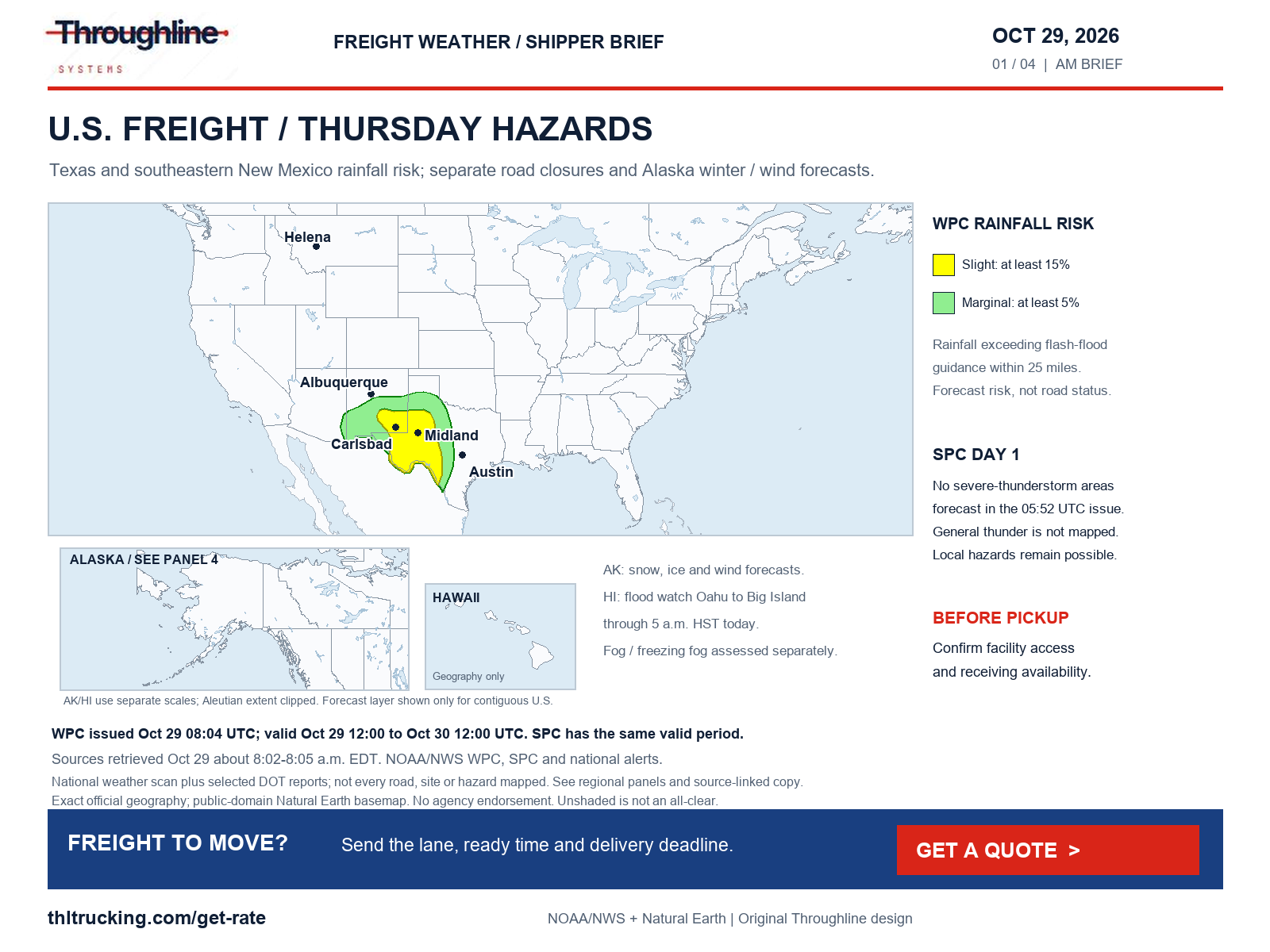
Sources: WPC Day 1 excessive-rainfall polygons; NMDOT NMRoads official closure feed; NWS national active-alert snapshot
Diesel: the October 26 week remains the latest observation
EIA’s October 27 release reports U.S. on-highway diesel at $6.352 per gallon for October 26, including taxes. That is 7.6 cents above October 19’s $6.276. The page still lists November 3 as the next release. These are weekly observations; there is no new daily diesel price in today’s retrieved update.
For a manufacturer comparing an enclosed FTL quote with a partial option, ask which index week and geography any fuel adjustment uses, what is included in the quoted total and when the offer expires. A retail diesel benchmark does not determine an individual shipment’s surcharge or total freight price.
| EIA geography | Oct 19, $/gal | Oct 26, $/gal | Weekly change, $/gal |
|---|---|---|---|
| U.S. | 6.276 | 6.352 | +0.076 |
| East Coast (PADD 1) | 5.984 | 6.079 | +0.095 |
| Midwest (PADD 2) | 6.352 | 6.480 | +0.128 |
| Gulf Coast (PADD 3) | 5.903 | 5.951 | +0.048 |
| Rocky Mountain (PADD 4) | 6.422 | 6.521 | +0.099 |
| West Coast (PADD 5) | 7.394 | 7.329 | −0.065 |
Sources: EIA weekly on-highway diesel update
Texas and southeastern New Mexico: forecast rain needs an access plan
WPC’s October 29 08:04 UTC Day 1 polygons put parts of west/central Texas and southeastern New Mexico in Slight excessive-rainfall risk, surrounded by Marginal risk. The period runs 12:00 UTC today to 12:00 UTC Friday, or 7 a.m.–7 a.m. CDT. The categories mean at least 15% and 5% probability, respectively, of rainfall exceeding flash-flood guidance within 25 miles of a point. They are not percentages of roads closed.
The 4:08 a.m. EDT discussion highlights prolonged rainfall this afternoon and tonight, including sensitive southeastern New Mexico terrain. The Midland-office flood watch, issued 1:44 a.m. MDT today, begins 9 a.m. MDT/10 a.m. CDT and runs through Friday afternoon; it forecasts 1–3 inches of event rain with locally higher amounts across its listed Lea County/Permian Basin/Trans-Pecos/Big Bend areas. This watch has its own geography and is not an observed rainfall total.
For lumber or machinery loaded outdoors, confirm the facility’s access and loading-pause procedures. For enclosed freight, verify the yard and dock can accept the truck even if the cargo itself is protected. Give the carrier a reachable site contact and set an ETA checkpoint with receiving. DriveTexas returned a client-rendered shell in this review, so no Texas highway closure is asserted from that fetch.
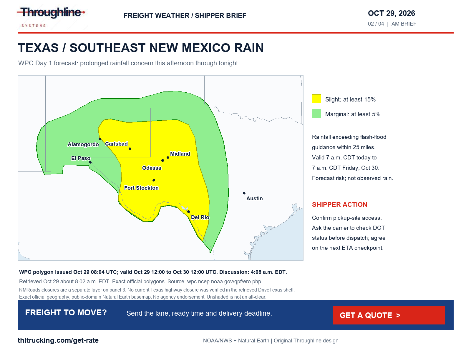
Sources: WPC Day 1 excessive-rainfall polygons; WPC excessive-rainfall discussion; NWS Flood Watch: Northern Lea County; Central Lea County; Southern Lea County; Gaines; Dawson; Borden; Scurry; Andrews; Martin; Howard; Mitchell; Winkler; Ector; Midland; Glasscock; Ward; Crane; Upton; Reagan; Pecos; Terrell; Central Brewster County; Chisos Basin; Lower Brewster County
New Mexico: verified closure segments remain separate from the rain forecast
NMDOT’s feed, retrieved at 8:04 a.m. EDT, identifies US 380 closures in both directions at mileposts 2–40 and separately 41–43. The records were updated October 28 at 7:57 a.m. and 9:21 a.m. MDT. The milepost 40–41 gap must not be described or drawn as part of a continuous closure.
US 491 is separately listed closed in both directions at milepost 34, two miles north of Buffalo Springs, updated October 28 at 11:32 p.m. MDT. The selected records do not supply a cause, vehicle exemption or reopening time. Placeholder end dates in the feed are not usable reopening estimates.
An NWS Socorro County flood warning issued October 28 at 6:40 p.m. MDT, valid until 6:45 p.m. MDT today, cites emergency-management reports of flooding near Escondida/Pueblito and impassable roads near San Pedro. That observed report is separate evidence; it does not establish why every highway record is closed. Have the carrier verify the actual movement and any authorized alternative before promising a new arrival.
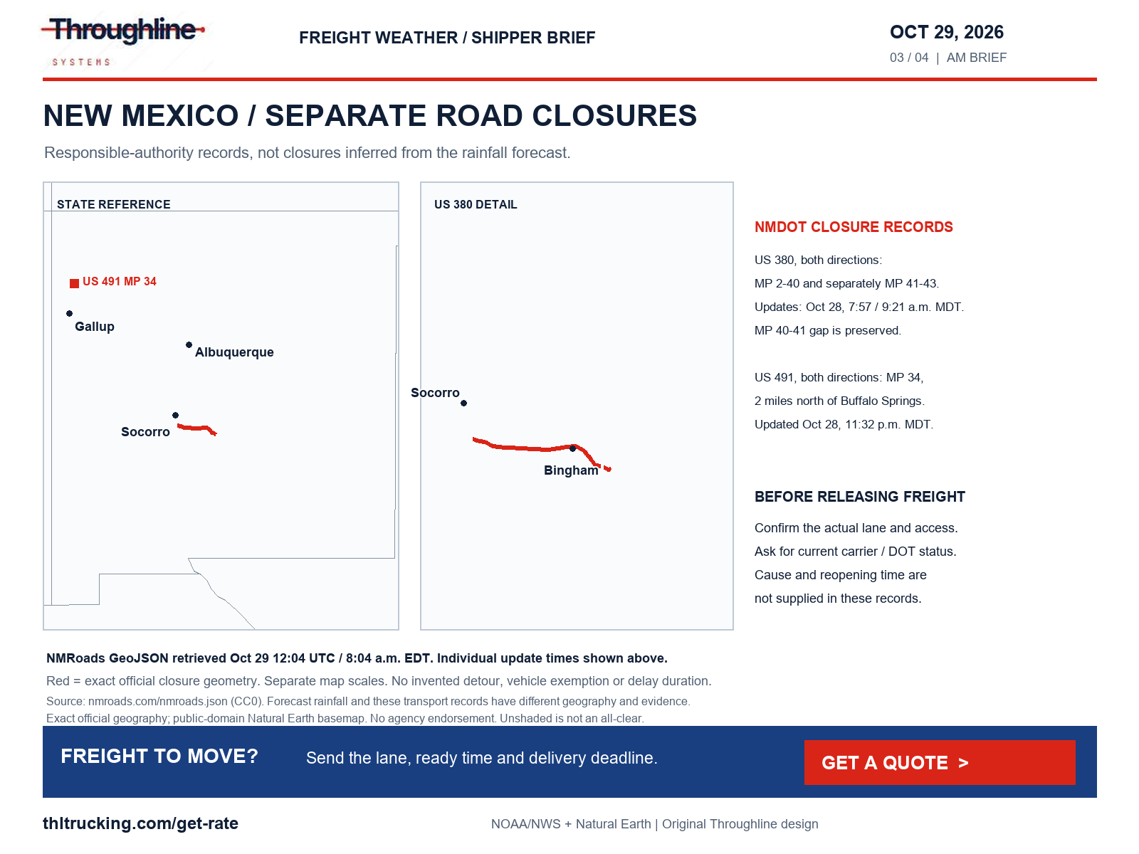
Sources: NMDOT NMRoads official closure feed; NWS Flood Warning: Socorro, NM
Alaska: snow, freezing rain and hillside wind have different clocks
Northern Susitna Valley, including the Parks Highway corridor through Broad Pass, has a Winter Storm Warning issued October 28 at 1:21 p.m. AKDT. It forecasts 7–15 inches total snow from 1 p.m. today to 2 p.m. Friday AKDT, with visibility potentially a quarter mile or less. Southern/central Susitna, from around Willow to the Talkeetna Spur Road, has a separate advisory for 2 a.m.–1 p.m. today: up to 2 inches snow and 0.1 inch ice. Do not add these amounts or transfer one zone’s period to another.
The Anchorage/Eagle River hillside Wind Advisory, issued October 28 at 2:57 p.m. AKDT, applies mainly above 1,000 feet from 3 p.m. today to 1 a.m. Friday AKDT: southeast winds 25–40 mph, gusting 50–60 mph. Separately, the Alaska Range/Windy Pass advisory issued October 28 at 2:23 p.m. AKDT runs through 7 a.m. today with gusts to 65 mph; its discussion forecasts stronger winds later Thursday. Neither product establishes a high-profile vehicle restriction.
Western Brooks/Red Dog Mine snow also remains a concern: the October 28 3:47 p.m. AKDT warning runs through 4 p.m. today, with 6–12 inches near Red Dog Mine and 12–18 inches in the Western Brooks Range; mostly rain is expected below 800 feet. These are forecast totals for that warning period. Confirm local access, exposed handling and receiving availability; Alaska DOT road restrictions were not independently inventoried in this review.
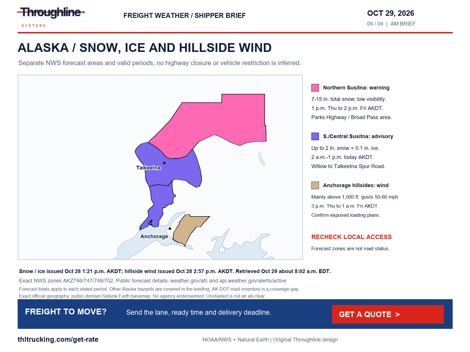
Sources: NWS Winter Storm Warning: Northern Susitna Valley; NWS Winter Weather Advisory: Southern Susitna Valley; Central Susitna Valley; NWS Wind Advisory: Anchorage Hillside / Eagle River; NWS Wind Advisory: Northern Denali Borough; Eastern Alaska Range North of Trims Camp; NWS Winter Storm Warning: South Slopes of the Western Brooks Range; Noatak Valley
Morning fog and the next mountain-snow window
Montana’s north-central plains/Gates of the Mountains fog advisory, issued 3:14 a.m. MDT today and valid through noon MDT, warns of quarter- to half-mile visibility and possible frost/slippery bridges. Eastern New Mexico’s Guadalupe/Curry/Roosevelt/De Baca/Chaves plains advisory, issued 5:59 a.m. MDT, runs through 9 a.m. MDT with visibility at or below a quarter mile. In affected areas, ask for a realistic departure/arrival update instead of assuming a dry-weather transit plan still applies.
Selected western Kansas/eastern Colorado advisories issued 5:52 a.m. MDT last through noon MDT/1 p.m. CDT; central Pennsylvania’s 4:55 a.m. EDT advisory lasts through 10 a.m. EDT. These are bounded advisory areas, not statewide road closures. The national snapshot also includes fog statements elsewhere; local non-alerted conditions are outside this review.
WPC’s 2:26 a.m. EDT winter discussion, valid 12:00 UTC October 29–12:00 UTC November 1, places the more substantial CONUS snow signal later in the period. For Day 3, Sierra terrain above 9,000 feet and Idaho Sawtooths above 8,500 feet have a 40–70% probability of more than 6 inches through early Sunday. This is not a Thursday lowland or highway snowfall forecast. Its significant CONUS icing probability is below 10%, which does not rule out local slick surfaces.
Sources: NWS Dense Fog Advisory: Northern High Plains; Eastern Glacier, Western Toole, and Central Pondera; Eastern Toole and Liberty; Southern High Plains; Eastern Pondera and Eastern Teton; Cascade County below 5000ft; Judith Basin County and Judith Gap; Fergus County below 4500ft; Gates of the Mountains; NWS Dense Fog Advisory: Guadalupe County; Curry County; Roosevelt County; De Baca County; Chaves County Plains; NWS Dense Fog Advisory: Kit Carson County; Cheyenne County; Sherman; Thomas; Sheridan; Graham; Wallace; Logan; Gove; Greeley; Wichita; NWS Dense Fog Advisory: McKean; Potter; Elk; Cameron; Northern Clinton; Clearfield; Northern Centre; Southern Centre; Cambria; Blair; Huntingdon; Mifflin; Juniata; Somerset; Bedford; Fulton; Northern Lycoming; Southern Clinton; Southern Lycoming; Union; Snyder; Montour; Northumberland; WPC heavy-snow and icing discussion
Road reports: check the vehicle and the exact facility approach
The current WSDOT dataset lists no restrictions in either direction at Stevens/US 2 and Snoqualmie/I-90. Its update and weather fields are blank or seasonal, so this does not establish dry pavement or an exact restriction-lifting time. WYDOT’s Rawlins–Laramie I-80 rows now show no restriction; the earlier high-profile weight restriction is not repeated here. The page clock is October 29 4:01, with those section rows showing October 28 19:17 and no time-zone label.
Separate WYDOT restrictions persist: the Higley Boulevard overpass at Exit 214 is closed for bridge damage, and westbound I-80 mileposts 48–48.5 have a 12-foot width restriction for emergency bridge-deck repair. An oversize open-deck shipment needs a vehicle-, dimension- and permit-specific check even when a wind restriction is absent.
MDOT’s morning feed reports a vehicle fire on I-75 in both directions at 11 Mile in Oakland County, blocking the left shoulder and left/center lanes; its displayed clock is 07:16 without a date/time-zone label. It does not state a full-interstate closure. Yesterday’s three highlighted Michigan incident IDs are absent; absence does not establish their precise reopening times.
Other selected agency reports retain flood closures on Utah SR 29 at milepost 9/Joes Valley and SR 162 mileposts 0–2/Bluff, updated October 26, and NC 12 near Rodanthe, updated October 23 at 16:37 with no displayed time zone. FL511 lists the Edgewood Avenue/SR 111 rail crossing near West Beaver Street/US 90 in Jacksonville closed for scheduled work through November 20, updated today at 05:48 with no time-zone label. These local restrictions matter when they intersect the shipment’s actual approach; no fixed transit delay is established.
Sources: WSDOT official mountain-pass report dataset; WYDOT I-80 road and travel report; MDOT Mi Drive incident report; UDOT selected traffic alerts; DriveNC selected alerts; Florida 511 selected alerts
Friday planning and coastal access
WPC’s Day 2 map, issued today at 08:04 UTC and valid 12:00 UTC Friday–12:00 UTC Saturday, shifts a Slight excessive-rainfall area into central/southern Arizona. A Yavapai/northern Gila flood watch issued 1:25 a.m. MST today is valid Friday 10 a.m.–10 p.m. MST. Check tomorrow’s pickup access and outdoor-storage plan with the site; do not present that future watch as an observed road closure.
The Florida Keys coastal-flood warning issued 5:38 a.m. EDT today lasts through 5 a.m. Friday. San Diego/Orange County coastal flooding is covered by a warning issued 1:44 a.m. PDT, through 1 p.m. today, followed by an advisory. Hawaii’s October 28 3:29 p.m. HST flood watch covers Oahu through the Big Island until 5 a.m. HST today; Kauai is not in that affected list. Confirm local facility access where relevant. These warnings and watches do not establish a port shutdown or the condition of every coastal road.
Sources: WPC Day 2 excessive-rainfall polygons; NWS Flood Watch: Yavapai County Mountains; Northern Gila County; Yavapai County Valleys and Basins; Oak Creek and Sycamore Canyons; NWS Coastal Flood Warning: Monroe Upper Keys; Monroe Middle Keys; Monroe Lower Keys; NWS Coastal Flood Warning: San Diego County Coastal Areas; Orange County Coastal; NWS Flood Watch: Waianae Coast; Oahu North Shore; Olomana; Central Oahu; Waianae Mountains; Lanai Mauka; Kahoolawe; Maui Windward West; Maui Leeward West; Haleakala Summit; Kona; Kohala; Big Island Interior; Big Island Summit; East Honolulu; Honolulu Metro; Ewa Plain; Koolau Windward; Koolau Leeward; Molokai Windward; Molokai Southeast; Molokai North; Molokai West; Molokai Leeward South; Lanai Windward; Lanai Leeward; Lanai South; Maui Central Valley North; Maui Central Valley South; Windward Haleakala; Kipahulu; South Maui/Upcountry; South Haleakala; Big Island South; Big Island Southeast; Big Island East; Big Island North
Port-area planning: the Vincent Thomas Bridge closure is scheduled for next week
Caltrans’ October 22 announcement schedules a full Vincent Thomas Bridge/SR 47 closure in San Pedro beginning November 7 at 12:01 a.m. local for 16 months, targeting early March 2028 reopening. This is a future project schedule, not a claim that the full bridge closure is active today. Caltrans’ separate October 23 notice schedules northbound SR 47 work between Harbor Boulevard and Ferry Street overnight, 10:45 p.m.–6:45 a.m., October 25–30, subject to change; this review does not verify live activation of each nightly closure.
The Port of Los Angeles project page says terminals will remain open and does not expect rail-cargo impact. Those are the port’s project expectations, not a guarantee of a particular truck’s turn time. If an imported machine, lumber shipment or replenishment load has a port-area pickup next week, confirm the terminal/warehouse approach, pickup instructions and receiving window with the transport provider before fixing downstream labor or installation plans.
Sources: Caltrans: Vincent Thomas Bridge full closure announcement; Caltrans: northbound SR 47 overnight work; Port of Los Angeles: bridge project and cargo access
Southwest rail: an older restoration projection is not today’s operating confirmation
The latest BNSF Southwest recovery notice returned by the official index is still dated October 26. It discussed flood damage on the Gallup and El Paso subdivisions, projected one Gallup track opening that afternoon and did not establish a return time for the second track or El Paso route. The retrieved notice does not confirm what actually reopened by October 29.
For a production-critical inbound shipment, obtain a current trace and reconcile the receiving plan before buying replacement transport. If only a small subset of parts is urgently needed, identify its actual packed size, weight and handling needs for a separate expedited assessment. Do not assume a sprinter or a replacement truck avoids the affected route or guarantees arrival.
Sources: BNSF Southwest flood-recovery notice
Coverage limits and the useful next handoff
All requested hazard categories were reviewed: wind and gusts; severe thunderstorms, tornadoes and hail; snow, blowing snow, blizzard, freezing rain, sleet and ice; flooding; fog, smoke, dust and visibility; and independent crashes, construction, emergency repairs, debris, slides, washouts, wildfire and bridge/road damage. The 8:02 a.m. EDT NWS snapshot contained no severe-thunderstorm/tornado warning or dedicated blizzard, sleet, dense-smoke, dust-storm or air-quality alert. SPC’s 05:52 UTC outlook forecasts no severe-thunderstorm areas today, and its current-watch page at 12:02 UTC explicitly has no valid watches. This does not guarantee an absence of local storms or unsafe surfaces.
SPC’s fire outlook issued 05:22 UTC, valid 12:00 UTC today–12:00 UTC Friday, has no critical areas. The latest NIFC report retrieved is October 28 at 7:30 a.m. MDT; it is not a fresh October 29 report, and no new named freight-highway wildfire closure was established here. DriveTexas, COTrip, Montana 511 and MnDOT’s selected list had data-access limitations. Alaska/Hawaii road inventories and every state, port, terminal and local approach were not assessed. Missing reports are not an all-clear.
Send the lane, cargo-ready time, packed dimensions/weight, equipment requirement, loading/unloading method and latest usable receiving time with a quote request. For open-deck loads, disclose oversize dimensions and protection needs; for enclosed FTL/partial loads, confirm dock access and acceptance. The contextual Get a quote action opens Throughline’s current public request flow. A request is an assessment step, not a reservation or arrival guarantee.
Sources: NWS national active-alert snapshot; SPC Day 1 convective outlook; SPC current watches; SPC Day 1 fire-weather outlook; NIFC incident management situation report
Sources and editorial notes
Original analysis by Throughline Systems. Source links may show newer releases after this article’s publication; the observation and issue dates below identify the material used. Agency citations do not imply endorsement.
- EIA weekly on-highway diesel update
Released October 27, 2026; observation October 26; comparison October 19. U.S. dollars per gallon, taxes included. Next listed release November 3; release clock not shown.
Accessed .
- WPC Day 1 excessive-rainfall polygons
Issued October 29 08:04 UTC; valid 12:00 UTC October 29 to 12:00 UTC October 30.
Accessed .
- WPC excessive-rainfall discussion
Issued October 29 4:08 a.m. EDT; Day 1 October 29–30 and Day 2 October 30–31, each beginning/ending 12:00 UTC.
Accessed .
- WPC Day 2 excessive-rainfall polygons
Issued October 29 08:04 UTC; valid 12:00 UTC October 30 to 12:00 UTC October 31.
Accessed .
- SPC Day 1 convective outlook
Issued October 29 05:52 UTC; valid 12:00 UTC October 29 to 12:00 UTC October 30.
Accessed .
- SPC current watches
Page updated October 29 12:02:08 UTC; no watches currently valid at retrieval.
Accessed .
- WPC heavy-snow and icing discussion
Issued October 29 2:26 a.m. EDT; valid 12:00 UTC October 29 to 12:00 UTC November 1.
Accessed .
- NMDOT NMRoads official closure feed
Individual US 380 records updated October 28 07:57:22 and 09:21:17 MDT; US 491 updated October 28 23:32:34 MDT. Feed contains legacy header metadata and placeholder end dates; neither is a reopening estimate.
Accessed .
- WYDOT I-80 road and travel report
Page clock October 29 04:01; Rawlins–Laramie rows October 28 19:17; displayed time zones not labeled. Construction restrictions have separate records.
Accessed .
- WSDOT official mountain-pass report dataset
Current fetched pass dataset; Stevens/Snoqualmie DisplayDate null. No exact update clock or road-surface observation supplied.
Accessed .
- MDOT Mi Drive incident report
I-75/11 Mile vehicle-fire record clock 07:16 at October 29 retrieval; displayed clock has no date/time-zone label.
Accessed .
- UDOT selected traffic alerts
SR 29 and SR 162 flood-closure notices updated October 26; no new reopening verified.
Accessed .
- DriveNC selected alerts
NC 12/Rodanthe flood-closure record updated October 23 16:37; displayed time zone unlabeled.
Accessed .
- Florida 511 selected alerts
Edgewood Avenue/SR 111 construction record updated October 29 05:48; displayed time zone unlabeled; scheduled through November 20.
Accessed .
- SPC Day 1 fire-weather outlook
Issued October 29 05:22 UTC; valid October 29 12:00 to October 30 12:00 UTC.
Accessed .
- NIFC incident management situation report
Latest retrieved document dated October 28 7:30 a.m. MDT; not a new October 29 report.
Accessed .
- NWS national active-alert snapshot
Retrieved October 29 12:02:30 UTC; individual bulletins carry separate issue and valid times.
Accessed .
- BNSF Southwest flood-recovery notice
Latest retrieved notice dated October 26, 2026; no publication clock shown. Earlier restoration projections are not October 29 confirmation.
Accessed .
- Caltrans: Vincent Thomas Bridge full closure announcement
Published October 22, 2026; planned closure November 7 at 12:01 a.m. local, targeted reopening early March 2028.
Accessed .
- Caltrans: northbound SR 47 overnight work
Published October 23, 2026; scheduled October 25–30, 10:45 p.m.–6:45 a.m. local, subject to change.
Accessed .
- Port of Los Angeles: bridge project and cargo access
Current project page; release date/clock not displayed. Terminal and rail statements are project expectations.
Accessed .
- NWS Winter Storm Warning: Northern Susitna Valley
Issued 2026-10-28T13:21:00-08:00; onset 2026-10-29T13:00:00-08:00; bulletin expiry 2026-10-29T16:00:00-08:00. Forecast validity is stated in the article; expiry can be an update deadline.
Accessed .
- NWS Winter Weather Advisory: Southern Susitna Valley; Central Susitna Valley
Issued 2026-10-28T13:21:00-08:00; onset 2026-10-29T02:00:00-08:00; bulletin expiry 2026-10-29T13:00:00-08:00. Forecast validity is stated in the article; expiry can be an update deadline.
Accessed .
- NWS Wind Advisory: Anchorage Hillside / Eagle River
Issued 2026-10-28T14:57:00-08:00; onset 2026-10-29T15:00:00-08:00; bulletin expiry 2026-10-29T16:00:00-08:00. Forecast validity is stated in the article; expiry can be an update deadline.
Accessed .
- NWS Wind Advisory: Northern Denali Borough; Eastern Alaska Range North of Trims Camp
Issued 2026-10-28T14:23:00-08:00; onset 2026-10-28T14:23:00-08:00; bulletin expiry 2026-10-29T07:00:00-08:00. Forecast validity is stated in the article; expiry can be an update deadline.
Accessed .
- NWS Winter Storm Warning: South Slopes of the Western Brooks Range; Noatak Valley
Issued 2026-10-28T15:47:00-08:00; onset 2026-10-28T15:47:00-08:00; bulletin expiry 2026-10-29T07:00:00-08:00. Forecast validity is stated in the article; expiry can be an update deadline.
Accessed .
- NWS Dense Fog Advisory: Northern High Plains; Eastern Glacier, Western Toole, and Central Pondera; Eastern Toole and Liberty; Southern High Plains; Eastern Pondera and Eastern Teton; Cascade County below 5000ft; Judith Basin County and Judith Gap; Fergus County below 4500ft; Gates of the Mountains
Issued 2026-10-29T03:14:00-06:00; onset 2026-10-29T03:14:00-06:00; bulletin expiry 2026-10-29T12:00:00-06:00. Forecast validity is stated in the article; expiry can be an update deadline.
Accessed .
- NWS Dense Fog Advisory: Guadalupe County; Curry County; Roosevelt County; De Baca County; Chaves County Plains
Issued 2026-10-29T05:59:00-06:00; onset 2026-10-29T06:00:00-06:00; bulletin expiry 2026-10-29T09:00:00-06:00. Forecast validity is stated in the article; expiry can be an update deadline.
Accessed .
- NWS Dense Fog Advisory: Kit Carson County; Cheyenne County; Sherman; Thomas; Sheridan; Graham; Wallace; Logan; Gove; Greeley; Wichita
Issued 2026-10-29T05:52:00-06:00; onset 2026-10-29T05:52:00-06:00; bulletin expiry 2026-10-29T12:00:00-06:00. Forecast validity is stated in the article; expiry can be an update deadline.
Accessed .
- NWS Dense Fog Advisory: McKean; Potter; Elk; Cameron; Northern Clinton; Clearfield; Northern Centre; Southern Centre; Cambria; Blair; Huntingdon; Mifflin; Juniata; Somerset; Bedford; Fulton; Northern Lycoming; Southern Clinton; Southern Lycoming; Union; Snyder; Montour; Northumberland
Issued 2026-10-29T04:55:00-04:00; onset 2026-10-29T04:55:00-04:00; bulletin expiry 2026-10-29T10:00:00-04:00. Forecast validity is stated in the article; expiry can be an update deadline.
Accessed .
- NWS Flood Warning: Socorro, NM
Issued 2026-10-28T18:40:00-06:00; onset 2026-10-28T18:40:00-06:00; bulletin expiry 2026-10-29T18:45:00-06:00. Forecast validity is stated in the article; expiry can be an update deadline.
Accessed .
- NWS Flood Watch: Northern Lea County; Central Lea County; Southern Lea County; Gaines; Dawson; Borden; Scurry; Andrews; Martin; Howard; Mitchell; Winkler; Ector; Midland; Glasscock; Ward; Crane; Upton; Reagan; Pecos; Terrell; Central Brewster County; Chisos Basin; Lower Brewster County
Issued 2026-10-29T01:44:00-06:00; onset 2026-10-29T09:00:00-06:00; bulletin expiry 2026-10-29T16:00:00-06:00. Forecast validity is stated in the article; expiry can be an update deadline.
Accessed .
- NWS Flood Watch: Yavapai County Mountains; Northern Gila County; Yavapai County Valleys and Basins; Oak Creek and Sycamore Canyons
Issued 2026-10-29T01:25:00-07:00; onset 2026-10-30T10:00:00-07:00; bulletin expiry 2026-10-29T12:15:00-07:00. Forecast validity is stated in the article; expiry can be an update deadline.
Accessed .
- NWS Flood Watch: Waianae Coast; Oahu North Shore; Olomana; Central Oahu; Waianae Mountains; Lanai Mauka; Kahoolawe; Maui Windward West; Maui Leeward West; Haleakala Summit; Kona; Kohala; Big Island Interior; Big Island Summit; East Honolulu; Honolulu Metro; Ewa Plain; Koolau Windward; Koolau Leeward; Molokai Windward; Molokai Southeast; Molokai North; Molokai West; Molokai Leeward South; Lanai Windward; Lanai Leeward; Lanai South; Maui Central Valley North; Maui Central Valley South; Windward Haleakala; Kipahulu; South Maui/Upcountry; South Haleakala; Big Island South; Big Island Southeast; Big Island East; Big Island North
Issued 2026-10-28T15:29:00-10:00; onset 2026-10-28T15:29:00-10:00; bulletin expiry 2026-10-29T05:00:00-10:00. Forecast validity is stated in the article; expiry can be an update deadline.
Accessed .
- NWS Coastal Flood Warning: Monroe Upper Keys; Monroe Middle Keys; Monroe Lower Keys
Issued 2026-10-29T05:38:00-04:00; onset 2026-10-29T05:38:00-04:00; bulletin expiry 2026-10-29T13:45:00-04:00. Forecast validity is stated in the article; expiry can be an update deadline.
Accessed .
- NWS Coastal Flood Warning: San Diego County Coastal Areas; Orange County Coastal
Issued 2026-10-29T01:44:00-07:00; onset 2026-10-29T01:44:00-07:00; bulletin expiry 2026-10-29T14:30:00-07:00. Forecast validity is stated in the article; expiry can be an update deadline.
Accessed .