November 3 logistics briefing: Mississippi Valley storms, flood closures and port access
Tuesday freight briefing: Mississippi Valley storm risk, Florida and Utah flood restrictions, Alaska snow, weekly diesel and the approaching port-area bridge closure.
By Throughline Systems · · 14 min read · Updated
What matters for your next load
- Storm and rainfall forecasts move into the Mississippi/Tennessee valleys; Florida and Utah have separately verified road restrictions.
- The latest available EIA diesel observation remains October 26 at $6.352 per gallon; a November 3 release was not yet present at the research cutoff.
- Recheck mountain and local access, and prepare next week’s port-area pickups for the planned November 7 Vincent Thomas Bridge closure.
Tuesday: check the receiving plan against today’s conditions
The main research cutoff is 7:05 a.m. EST on November 3, with a New Mexico road follow-up at about 7:15 a.m. EST; the useful freight decisions are regional: prepare for storms and heavy-rain risk in parts of the Mississippi and Tennessee valleys, verify Florida and Utah flood-related access restrictions, and revisit mountain-road conditions before committing to a delivery appointment. The national map shows one forecast layer; it is not a route clearance.
For manufacturers, lumber suppliers and distributors, the next handoff should identify who confirms the pickup site, who receives an ETA change and what happens if outdoor loading pauses. A dedicated truck or enclosed trailer does not make a flooded yard accessible. An expedited sprinter still needs a compatible load, an accepted route and a receiver who can unload it.
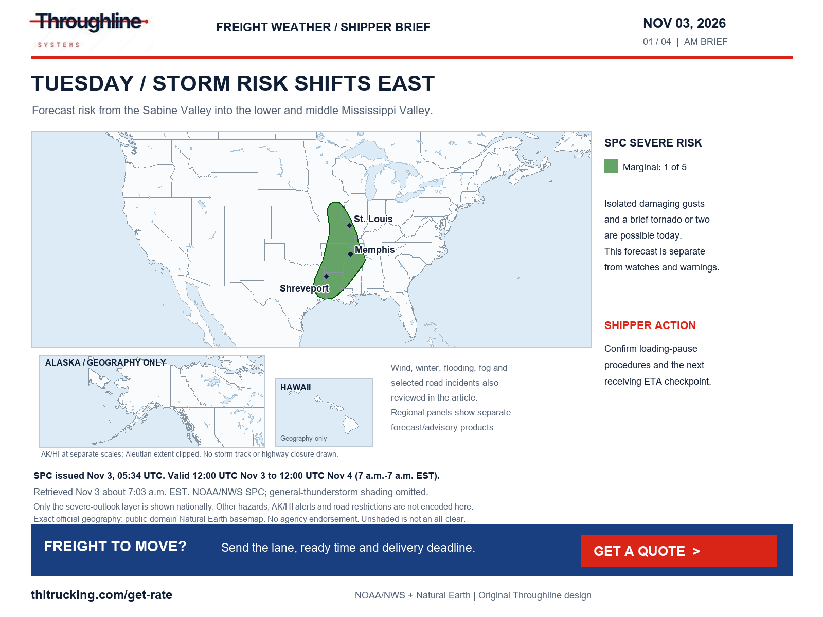
Sources: SPC Day 1 convective outlook; WPC excessive-rainfall discussion; Florida 511 selected alerts; UDOT selected traffic alerts
Diesel: the latest available observation is still October 26
At the 7:03 a.m. EST retrieval, EIA’s page still showed the October 27 release and listed November 3 as its next release date. The latest U.S. on-highway diesel observation was October 26: $6.352 per gallon, including taxes, up $0.076 per gallon from $6.276 on October 19. This is a weekly comparison, not a November 3 pump-price measurement.
For a quote comparison, ask which fuel index, observation week and adjustment terms apply. A national retail diesel average is neither a freight rate nor a promise about today’s lane price. If a new EIA release appears after this briefing’s cutoff, use the newly applicable week according to the actual quote terms rather than relabeling the older observation.
| Geography | October 26 ($/gal) | Week change ($/gal) |
|---|---|---|
| U.S. | 6.352 | +0.076 |
| Midwest | 6.480 | +0.128 |
| Gulf Coast | 5.951 | +0.048 |
| Rocky Mountain | 6.521 | +0.099 |
| West Coast | 7.329 | −0.065 |
Sources: EIA weekly on-highway diesel update
Mississippi and Tennessee valleys: forecasts, not confirmed highway closures
SPC’s 05:34 UTC Day 1 outlook places parts of the Sabine River Valley through the lower and middle Mississippi Valley in Marginal severe-thunderstorm risk, level 1 of 5. It identifies isolated damaging gusts and possible brief tornadoes as the principal concerns. The forecast runs 7 a.m. EST today to 7 a.m. EST Wednesday. The overnight Plains outlook is a different, expired product and is not reused here.
WPC’s 08:18 UTC polygons and 3:20 a.m. EST discussion identify Slight excessive-rainfall risk across portions of the lower Mississippi and Tennessee valleys, with a separate area over southeast Florida. The valid period is also 12:00 UTC November 3–4. Marginal and Slight mean at least 5% and 15% probability of rainfall exceeding flash-flood guidance within 25 miles of a point; they do not measure the share of roads closed.
Treat a loading pause and an arrival change as separate decisions. Confirm the site’s storm procedures, outdoor staging arrangements and the person authorized to update the receiving window. A forecast area alone cannot establish whether a named highway or facility entrance is closed.
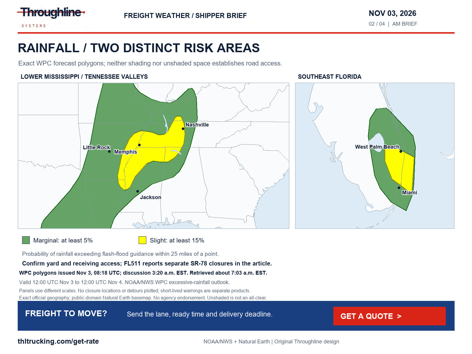
Sources: SPC Day 1 convective outlook; WPC Day 1 excessive-rainfall polygons; WPC excessive-rainfall discussion
Florida and Utah: check the precise closed segment
FL511’s Okeechobee County notice lists all lanes closed on SR 78 east at SW 16th Avenue and west at US 441/US 98, updated November 2 at 9:35 p.m. Its separate Glades County notice lists all lanes closed on SR 78 east at SR 29 and west at Ortona Road, updated November 2 at 2:52 p.m. These are the agency’s named locations, not a claim that every mile of SR 78 is closed. Displayed clocks have no time-zone label.
UDOT’s 4:57 a.m. November 3 notice lists SR 163 closed between mileposts 25 and 41 because of flooding. Its November 2 6:26 p.m. update lists one lane open with alternating traffic on SR 262 at milepost 20. The notices supply no dependable reopening estimate. Confirm the actual approach with the carrier and receiving site before releasing a truck or booking unloading labor.
Sources: Florida 511 selected alerts; UDOT selected traffic alerts
Southwest river flooding: a drier forecast does not restore access
The national alert review also finds continuing river-flood impacts in the Southwest. NWS Albuquerque’s 2:21 a.m. MST warning, valid through 8 a.m. MST today, reports La Plata River flooding affecting the Pinon Hills bridge area near Farmington. NWS Grand Junction’s November 2 8:26 p.m. MST warning covers south-central La Plata County, Colorado, through 3:15 p.m. MST today, describing flooding around the Animas River corridor from Durango toward Bondad and the state line. These are NWS impact reports; they do not independently confirm the open/closed status of a named state highway.
An upper Conejos River warning issued November 2 at 3:47 p.m. MST, valid through 3:45 p.m. MST today, describes continuing flooding from below Platoro through Mogote and inundated low-water crossings. For deliveries near affected rivers, confirm the actual facility entrance and local receiving access even if rain has stopped. COtrip’s retrieved page did not expose the incident details needed to verify a particular Colorado highway closure.
A follow-up NMDOT feed check at approximately 7:15 a.m. EST separately confirms NM 17 northbound closed at milepost 9, one mile south of Colorado; NM 112 in both directions at milepost 30, one mile south of El Vado; and NM 95 in both directions at milepost 13. Their record updates are November 2 at 9:56 a.m. MST, November 1 at 6:40 a.m. MST, and November 2 at 12:34 p.m. MST, respectively. The feed does not establish a cause, vehicle exemption or reopening estimate for these records. Do not infer that the flood warnings explain every closure.
Sources: NWS Flood Warning: San Juan, NM; NWS Flood Warning: La Plata, CO; NWS Flood Warning: Conejos, CO; NMDOT official road-event feed
Wyoming and selected road reports: current restrictions need their own evidence
The WYDOT I-80 report updated at 5 a.m. November 3 lists slick conditions, blowing snow and black ice from Laramie through Happy Jack Road to Buford, with segment reports at 3:52 and 3:59 a.m. The retrieved rows list no restriction; that is a change from the high-profile vehicle limits in the previous evening’s review, not proof that the route is safe or that later restrictions cannot be imposed. The page does not label its clock’s time zone.
Independent of the forecast, the same report lists an eastbound right-lane blockage from a stalled semi near Laramie at milepost 321.6. It also retains the Higley Boulevard overpass closure at I-80 Exit 214 near Rawlins for bridge damage. That overpass closure must not be described as closure of the I-80 mainline. Ask the carrier for a fresh condition check and revise the appointment only from an updated movement plan.
Construction matters even without a weather warning: FL511 lists the Edgewood Avenue/SR 111 railroad crossing near West Beaver Street/US 90 in Jacksonville closed for scheduled work through November 20, updated at 7 a.m. today. WSDOT’s fetched pass dataset describes frost/ice in places at Stevens Pass while listing no restriction there; its update fields are null, so the observation age cannot be established. MDOT’s returned US 131/Pearl Street crash entry is explicitly cleared and is not an active closure in this briefing.
DriveNC’s November 3 4:30 a.m. notice separately lists I-73 northbound closed at Exit 39 in Montgomery County because of a crash, incident 26110300003. This short-lived road incident is independent of the weather forecast. Recheck the official incident with the carrier before estimating its effect on a pickup or delivery; the source does not support a fixed delay duration.
Sources: WYDOT I-80 travel report; Florida 511 selected alerts; WSDOT mountain-pass report dataset; MDOT Mi Drive incidents; DriveNC special alerts
Southeast Alaska tonight; high-elevation Rockies planning for Wednesday
NWS Juneau’s 1:50 a.m. AKST advisory forecasts up to 5 inches total snow on the Klondike Highway including White Pass, from 6 p.m. today to 6 a.m. Wednesday AKST. Snow levels near 1,800 feet limit accumulation below about highway milepost 10. The mapped Municipality of Skagway zone is broader than that highway-specific forecast.
Separate wind advisories issued at 2:50 a.m. AKST forecast gusts to 45 mph: Prince of Wales Island from 6 p.m. today–3 a.m. Wednesday, and Annette Island from 9 p.m.–6 a.m. AKST. Confirm local receiving and exposed handling arrangements. The Alaska 511 alert list returned no alerts; that narrow result is not a full road-condition inventory and does not establish a closure, chain requirement or unrestricted route.
WPC’s 2:39 a.m. EST winter discussion covers November 3–6. Its Day 2 signal, 12:00 UTC November 4–5, gives a 30–60% probability of at least 6 inches of snow in the Sawatch/Mosquito ranges into the northern Sangre de Cristo Mountains of Colorado, mainly above 11,000 feet. That is a high-terrain forecast, not a snowfall amount for I-70 or a lowland dock. WPC’s CONUS significant-ice probability below 10% does not rule out black ice on individual roads. Recheck the actual corridor before confirming a Wednesday pickup.
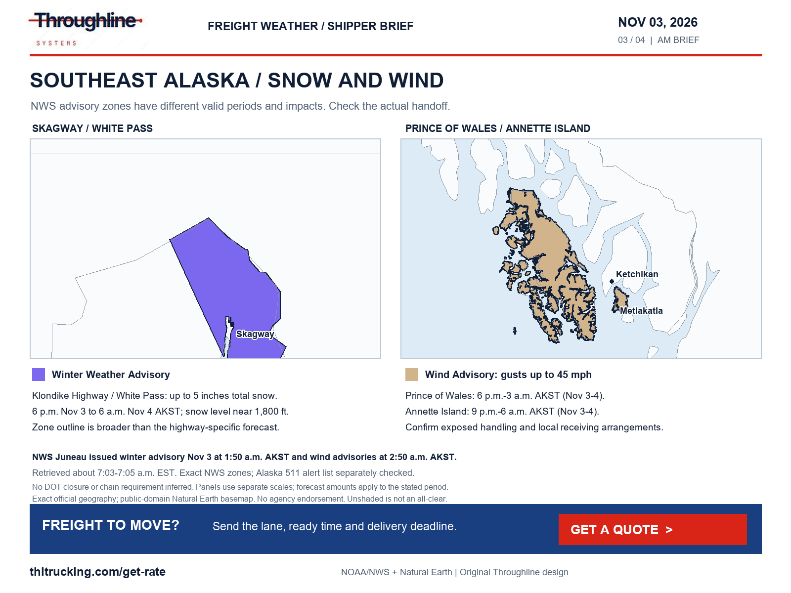
Sources: NWS Winter Weather Advisory: Municipality of Skagway; NWS Wind Advisory: Prince of Wales Island; NWS Wind Advisory: Annette Island; Alaska 511 alert list; WPC heavy-snow and icing discussion
Wind and fog: assess exposed handling as well as transit
For California’s Mojave Desert Slopes, NWS issued a Wind Advisory at 3:01 a.m. PST today for 4 p.m. today–6 a.m. Wednesday PST: west winds 15–25 mph, gusting to 45 mph. Caltrans’ separate SR 58 report as of 4:04 a.m. lists no traffic restriction in its central California area; this does not forecast tonight’s access. Hawaii’s advisory, issued November 2 at 2:25 p.m. HST, runs through 6 a.m. HST today for selected Lanai, Maui and northern Big Island zones, with northeast winds 15–30 mph and gusts to 50 mph.
Union County, New Mexico, has a 4:18 a.m. MST advisory through 8 a.m. MST for north winds 25–35 mph, gusting to 50 mph. In northeastern Arkansas and the Missouri Bootheel, a 2:39 a.m. CST advisory covers the listed Clay, Greene, Craighead, Mississippi, Dunklin and Pemiscot counties from 8 a.m.–3 p.m. CST, with south winds 20–25 mph and gusts to 35 mph. None establishes a high-profile vehicle restriction without transport-authority confirmation.
Grande Ronde Valley, Oregon, has a Dense Fog Advisory issued November 2 at 11:02 p.m. PST, valid through 10 a.m. PST today, for visibility of a quarter mile to one mile. A separate NWS statement issued 4:33 a.m. EST describes patchy dense fog in southeast Virginia and northeast North Carolina, with locally half-mile-or-less visibility through about 8–9 a.m.; the bulletin expires at 8 a.m. EST. Recheck before departure. For open-deck loading, confirm the site’s handling procedures; for enclosed freight, confirm access and the revised ETA rather than assuming cargo protection resolves visibility.
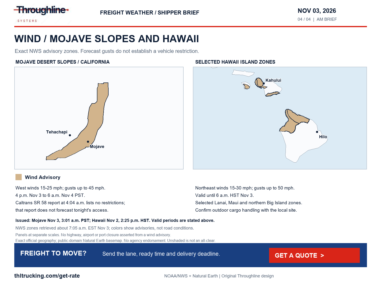
Sources: NWS Wind Advisory: Mojave Desert Slopes; Caltrans SR 58 conditions; NWS Wind Advisory: Lanai Mauka; Maui Windward West; Maui Leeward West; Kohala; Maui Central Valley South; South Haleakala; Big Island North; NWS Wind Advisory: Union County; NWS Wind Advisory: Clay; Greene; Craighead; Mississippi; Dunklin; Pemiscot; NWS Dense Fog Advisory: Grande Ronde Valley; NWS Special Weather Statement: Northampton; Hertford; Gates; Pasquotank; Camden; Western Currituck; Bertie; Chowan; Perquimans; Greensville; Sussex; Surry; James City; Southampton; Chesapeake; Virginia Beach; York; Newport News; Hampton/Poquoson; Isle of Wight; Suffolk; Norfolk; Portsmouth
Port-area planning: the Vincent Thomas Bridge closure approaches
Caltrans’ October 22 announcement schedules the full Vincent Thomas Bridge/SR 47 closure in San Pedro to start Saturday, November 7 at 12:01 a.m. local, for 16 months, with reopening targeted for early March 2028. This is an approaching planned closure, not a report that the full closure is active today. Confirm the terminal or warehouse approach and the transport provider’s plan before fixing next week’s downstream installation or receiving labor.
The Port of Los Angeles project page says its terminals will remain open and expects no rail-cargo impact. Those are the port’s stated project expectations, not a guarantee for an individual truck’s turn time. The practical question is which pickup and appointment instructions apply to the actual facility.
The BNSF official index still returns an October 26 Southwest flood-recovery notice as its latest item on that event. Earlier restoration projections do not establish the November 3 operating status of the Gallup or El Paso subdivisions. For production-critical inbound freight, obtain a current shipment trace before purchasing replacement transport; identify the urgent subset of parts and its packed dimensions if an expedited alternative needs assessment.
Sources: Caltrans Vincent Thomas Bridge closure announcement; Port of Los Angeles bridge project and cargo access; BNSF Southwest flood-recovery notice
Coverage limits and the next useful shipment decision
The review explicitly checked high winds and gusts; severe thunderstorms, damaging winds, tornadoes and hail; snow, blowing snow, blizzard, freezing rain, sleet and ice; flooding; fog, smoke, dust and other visibility hazards. The 7:03 a.m. EST national NWS snapshot had no dedicated high-wind warning, blizzard, freezing-rain, sleet, dense-smoke or dust-storm alert. That describes the snapshot, not the absence of hazards outside alert criteria or in unobserved areas.
SPC’s 05:47 UTC fire outlook has no critical CONUS areas for 12:00 UTC November 3–4. The latest NIFC report retrieved is still labeled November 2, 0730 MDT, and lists six uncontained large fires; it does not verify a new named freight-highway fire closure for this briefing. Do not interpret the fire outlook as a smoke or road all-clear.
Independent incident review included stalled vehicles, crashes, construction, emergency repairs, debris, slides, washouts, wildfire closures and bridge/road damage in selected DOT sources. It is not a 50-state incident census. Colorado, Montana and several other fetched traffic pages exposed limited client-rendered content; Oregon’s custom report and Alaska’s alert list do not establish complete route coverage. No new freight closure from debris, a slide or wildfire was verified within these checked sources. The original maps show only the stated products, preserve official geometry and use public-domain Natural Earth boundaries; no agency endorsement is implied.
For freight ready to move, provide the pickup and delivery locations, finished dimensions and weight, loading/unloading method, ready time and true delivery deadline. Request a quote for the appropriate FTL, partial, open-deck, enclosed or expedited option, then confirm the offered equipment and receiving arrangement. Use the linked pickup and appointment guides to close missing details before approving the movement.
- Before release: verify the actual site entrance and the responsible contact.
- Before promising arrival: obtain a current carrier update and a receiver-confirmed window.
- Before expediting: identify the minimum urgent shipment and confirm vehicle/loading fit.
Sources: NWS national active-alert snapshot; SPC Day 1 fire-weather outlook; NIFC incident management situation report
Sources and editorial notes
Original analysis by Throughline Systems. Source links may show newer releases after this article’s publication; the observation and issue dates below identify the material used. Agency citations do not imply endorsement.
- EIA weekly on-highway diesel update
Release October 27, 2026; observations October 26 and October 19. U.S. dollars per gallon including taxes. Next listed release November 3; no new release was present at retrieval.
Accessed .
- SPC Day 1 convective outlook
Issued November 3 05:34 UTC; valid November 3 12:00 UTC to November 4 12:00 UTC.
Accessed .
- WPC Day 1 excessive-rainfall polygons
Issued November 3 08:18 UTC; valid November 3 12:00 UTC to November 4 12:00 UTC.
Accessed .
- WPC excessive-rainfall discussion
Issued November 3 3:20 a.m. EST. Day 1 valid 12:00 UTC November 3–4; Day 2 November 4–5.
Accessed .
- WPC heavy-snow and icing discussion
Issued November 3 2:39 a.m. EST; valid November 3 12:00 UTC to November 6 12:00 UTC. Central Rockies signal is Day 2, November 4–5.
Accessed .
- WYDOT I-80 travel report
Page update November 3 05:00; Laramie/Happy Jack/Buford rows 03:52 and 03:59. Displayed clocks do not identify a time zone; older rows retain their own report times.
Accessed .
- Florida 511 selected alerts
Okeechobee SR 78 updated November 2 21:35; Glades November 2 14:52; Jacksonville construction November 3 07:00. Displayed time zones not labeled.
Accessed .
- UDOT selected traffic alerts
SR 163 flood closure updated November 3 04:57; SR 262 alternating traffic November 2 18:26. Displayed time zones not labeled.
Accessed .
- WSDOT mountain-pass report dataset
Current retrieved dataset; individual DisplayDate fields are null, so an observation/update time cannot be established.
Accessed .
- MDOT Mi Drive incidents
Returned US 131/Pearl Street crash record explicitly marked cleared at 07:02; clock has no date/time-zone label. Not presented as an active blockage.
Accessed .
- Caltrans SR 58 conditions
Page as-of November 3 04:04; no restrictions reported for the central California area at that check. Displayed time zone not labeled.
Accessed .
- Alaska 511 alert list
List returned no alerts at retrieval; this is not a complete road-condition or restriction inventory.
Accessed .
- Caltrans Vincent Thomas Bridge closure announcement
Published October 22, 2026; planned start November 7 at 12:01 a.m. local; targeted reopening early March 2028.
Accessed .
- Port of Los Angeles bridge project and cargo access
Current project page; no publication/update clock displayed. Terminal and rail statements describe project expectations.
Accessed .
- BNSF Southwest flood-recovery notice
Dated October 26, 2026; no publication clock. Still the latest Southwest flood item returned by the retrieved official index.
Accessed .
- NWS national active-alert snapshot
Retrieved November 3 12:03 UTC; each bulletin has its own issue and validity times.
Accessed .
- SPC Day 1 fire-weather outlook
Issued November 3 05:47 UTC; valid November 3 12:00 UTC to November 4 12:00 UTC.
Accessed .
- NIFC incident management situation report
Latest retrieved PDF labeled November 2, 2026 at 0730 MDT, as printed by the agency. Not a new November 3 report.
Accessed .
- NWS Wind Advisory: Mojave Desert Slopes
Issued 2026-11-03T03:01:00-08:00; onset 2026-11-03T16:00:00-08:00; end 2026-11-04T06:00:00-08:00; bulletin expiry 2026-11-03T11:15:00-08:00. See article for hazard-specific validity.
Accessed .
- NWS Wind Advisory: Lanai Mauka; Maui Windward West; Maui Leeward West; Kohala; Maui Central Valley South; South Haleakala; Big Island North
Issued 2026-11-02T14:25:00-10:00; onset 2026-11-02T14:25:00-10:00; end 2026-11-03T06:00:00-10:00; bulletin expiry 2026-11-03T03:30:00-10:00. See article for hazard-specific validity.
Accessed .
- NWS Wind Advisory: Union County
Issued 2026-11-03T04:18:00-07:00; onset 2026-11-03T04:18:00-07:00; end 2026-11-03T08:00:00-07:00; bulletin expiry 2026-11-03T08:00:00-07:00. See article for hazard-specific validity.
Accessed .
- NWS Wind Advisory: Clay; Greene; Craighead; Mississippi; Dunklin; Pemiscot
Issued 2026-11-03T02:39:00-06:00; onset 2026-11-03T08:00:00-06:00; end 2026-11-03T15:00:00-06:00; bulletin expiry 2026-11-03T15:00:00-06:00. See article for hazard-specific validity.
Accessed .
- NWS Winter Weather Advisory: Municipality of Skagway
Issued 2026-11-03T01:50:00-09:00; onset 2026-11-03T18:00:00-09:00; end 2026-11-04T06:00:00-09:00; bulletin expiry 2026-11-03T12:15:00-09:00. See article for hazard-specific validity.
Accessed .
- NWS Wind Advisory: Prince of Wales Island
Issued 2026-11-03T02:50:00-09:00; onset 2026-11-03T18:00:00-09:00; end 2026-11-04T03:00:00-09:00; bulletin expiry 2026-11-03T12:15:00-09:00. See article for hazard-specific validity.
Accessed .
- NWS Wind Advisory: Annette Island
Issued 2026-11-03T02:50:00-09:00; onset 2026-11-03T21:00:00-09:00; end 2026-11-04T06:00:00-09:00; bulletin expiry 2026-11-03T12:15:00-09:00. See article for hazard-specific validity.
Accessed .
- NWS Dense Fog Advisory: Grande Ronde Valley
Issued 2026-11-02T23:02:00-08:00; onset 2026-11-02T23:02:00-08:00; end 2026-11-03T10:00:00-08:00; bulletin expiry 2026-11-03T10:00:00-08:00. See article for hazard-specific validity.
Accessed .
- NWS Special Weather Statement: Northampton; Hertford; Gates; Pasquotank; Camden; Western Currituck; Bertie; Chowan; Perquimans; Greensville; Sussex; Surry; James City; Southampton; Chesapeake; Virginia Beach; York; Newport News; Hampton/Poquoson; Isle of Wight; Suffolk; Norfolk; Portsmouth
Issued 2026-11-03T04:33:00-05:00; onset 2026-11-03T04:33:00-05:00; end None; bulletin expiry 2026-11-03T08:00:00-05:00. See article for hazard-specific validity.
Accessed .
- NWS Flood Warning: San Juan, NM
Issued 2026-11-03T02:21:00-07:00; valid until 2026-11-03T08:00:00-07:00.
Accessed .
- NWS Flood Warning: La Plata, CO
Issued 2026-11-02T20:26:00-07:00; valid until 2026-11-03T15:15:00-07:00.
Accessed .
- NWS Flood Warning: Conejos, CO
Issued 2026-11-02T15:47:00-07:00; valid until 2026-11-03T15:45:00-07:00.
Accessed .
- NMDOT official road-event feed
NM17 northbound milepost9 updated November2 09:56:45 MST; NM112 milepost30 November1 06:40:37 MST; NM95 milepost13 November2 12:34:26 MST. Unknown causes/vehicle exceptions; placeholder 2099 end dates are not reopening estimates.
Accessed .
- DriveNC special alerts
I73 northbound Exit39 crash closure notice updated November3 04:30; displayed time zone unlabeled; incident 26110300003.
Accessed .