November 4 logistics briefing: Colorado snow, Southeast storms and freight access
November 4 shipper briefing: Colorado snow advisories, Southeast storms, fog and road reports, weekly diesel at $6.292, and November 7 port-access planning.
By Throughline Systems · · 14 min read
What matters for your next load
- Plan Colorado mountain arrivals around afternoon-to-overnight snow advisories; confirm actual CDOT restrictions separately.
- Southeast storms, regional wind and morning fog require distinct checks; official road reports also identify flood, crash and construction impacts.
- EIA’s November 2 weekly diesel average is $6.292 per gallon; port-linked shippers should prepare for the November 7 Vincent Thomas Bridge closure.
Wednesday’s shipping priorities
Research snapshot: November 4, 2026, about 6:58–7:02 a.m. EST. Colorado mountain snow is now covered by afternoon-to-overnight NWS advisories. The severe-storm outlook is centered on the Southeast and southern Appalachians, while morning fog and continuing flood closures require separate checks. The national map below shows severe-storm risk only; it does not summarize every hazard or certify any lane clear.
For an outbound manufacturer or distributor, the useful decision is whether the pickup, route and receiving appointment still fit together. Get a fresh carrier arrival estimate, confirm the receiver’s latest acceptance time, and identify who can change the appointment before releasing a time-sensitive load. No fixed transit-delay estimate is supported by this review.
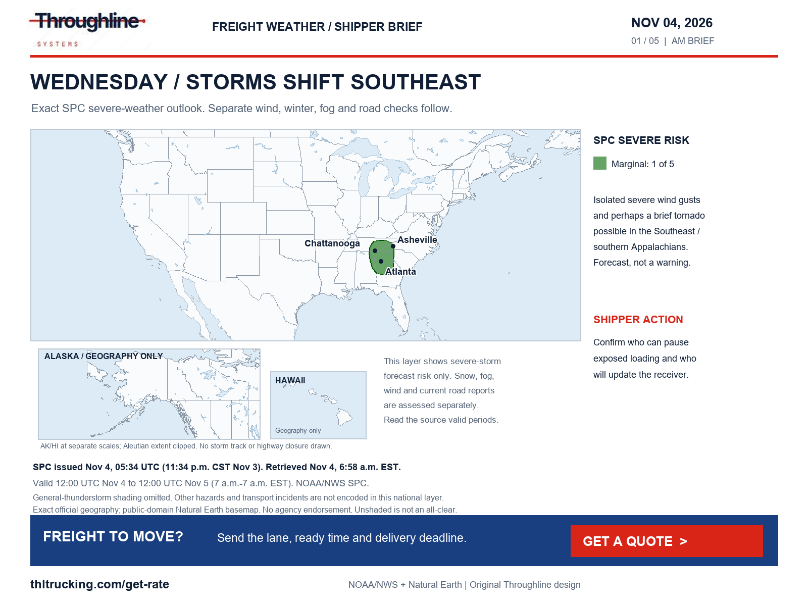
Sources: SPC Day 1 convective outlook; NWS national active-alert snapshot
Diesel: the latest weekly U.S. average is $6.292 per gallon
EIA’s November 3 release reports U.S. on-highway diesel at $6.292 per US gallon for November 2, down $0.060 from October 26. These are weekly retail observations including taxes, not daily freight quotes. The next scheduled release is November 10.
For quote comparisons, ask which fuel index, observation week and surcharge basis each offer uses. A lower weekly benchmark does not establish that a particular shipment’s total price fell; compare the same lane, equipment, timing and included services.
| EIA geography | November 2, USD/gal | Change from October 26, USD/gal |
|---|---|---|
| United States | 6.292 | −0.060 |
| Midwest | 6.402 | −0.078 |
| Gulf Coast | 5.912 | −0.039 |
| Rocky Mountain | 6.445 | −0.076 |
| West Coast | 7.272 | −0.057 |
| California | 8.076 | −0.079 |
Sources: EIA gasoline and diesel fuel update
Southeast storms and rainfall: two different forecasts
SPC’s outlook issued at 05:34 UTC November 4 places a Marginal severe-storm risk, level 1 of 5, over parts of the Southeast and southern Appalachians. It describes isolated severe gusts and possibly a brief tornado, with a morning cluster near northeastern Alabama and northwestern Georgia and an afternoon opportunity from central Georgia toward the southern Appalachians. This is a forecast, not a tornado warning or a highway closure.
WPC’s 3:10 a.m. EST discussion places a separate Marginal excessive-rainfall risk over parts of the Ohio and Tennessee valleys, southern Appalachians and southeastern Florida. Both Day 1 products cover 7 a.m. EST November 4 through 7 a.m. EST November 5. The rainfall category means at least a 5% chance of rainfall exceeding flash-flood guidance within 25 miles of a point; it is not a 5% road-closure probability.
For open-deck loading, identify the site contact who can pause exposed work. For enclosed and partial shipments, check yard access and whether a receiving appointment can move if the carrier’s arrival estimate changes. Existing flooding can persist outside today’s forecast shading.
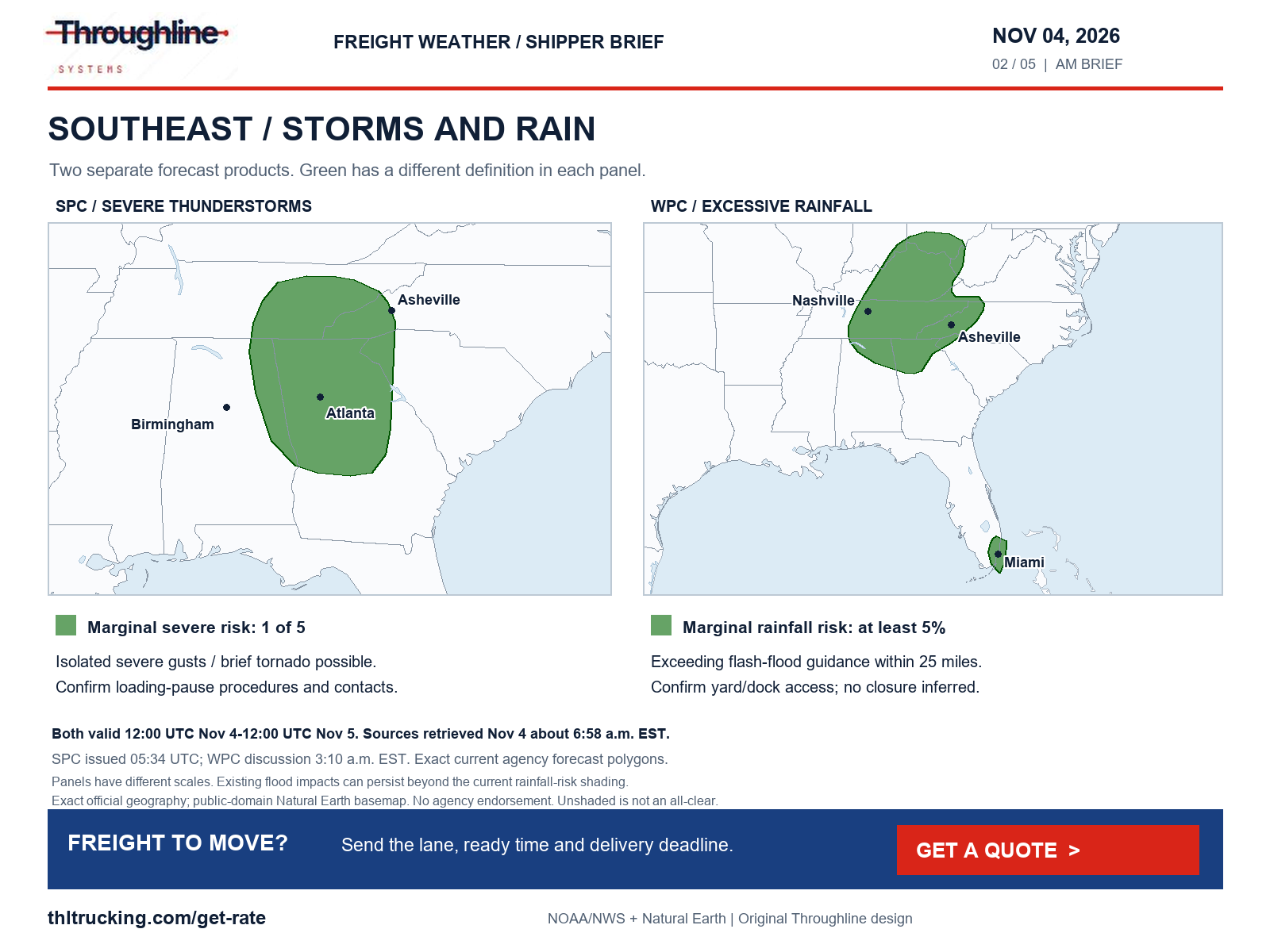
Sources: SPC Day 1 convective outlook; WPC excessive rainfall discussion
Colorado: plan afternoon and overnight mountain deliveries around new advisories
NWS issued the Summit Mountains, Mosquito Range, Indian Peaks and South Park advisory at 4:53 a.m. MST November 4: 3–10 inches of event-total snow, locally higher in the Mosquito Range, from 2 p.m. Wednesday to 2 a.m. Thursday. A separate 4:49 a.m. MST advisory forecasts 4–9 inches, locally 11, in selected Sawatch, Chaffee, Mosquito and Pikes Peak mountain zones from 2 p.m. to 5 a.m. MST November 4–5. Those zones have different elevation boundaries; the totals do not apply uniformly to nearby cities or lower valleys.
The Gore and Elk Mountains above 10,000 feet have a 4–8 inch advisory, locally higher, for 2 p.m. November 4 to 5 a.m. November 5 MST, issued at 9:16 p.m. MST November 3. WPC’s 2:17 a.m. EST winter discussion supports the Colorado mountain focus; its November 4–7 assessment keeps the probability of significant ice below 10% over the contiguous United States. That threshold is not a statement that every road will be ice-free.
NWS names potential slippery spots on US 285, but our COtrip retrieval did not expose a usable current CDOT restriction list. No chain requirement, high-profile vehicle restriction or highway closure is inferred. Ask the carrier to check CDOT immediately before release, then reconfirm evening unloading staff and the receiver’s procedure for a changed arrival.
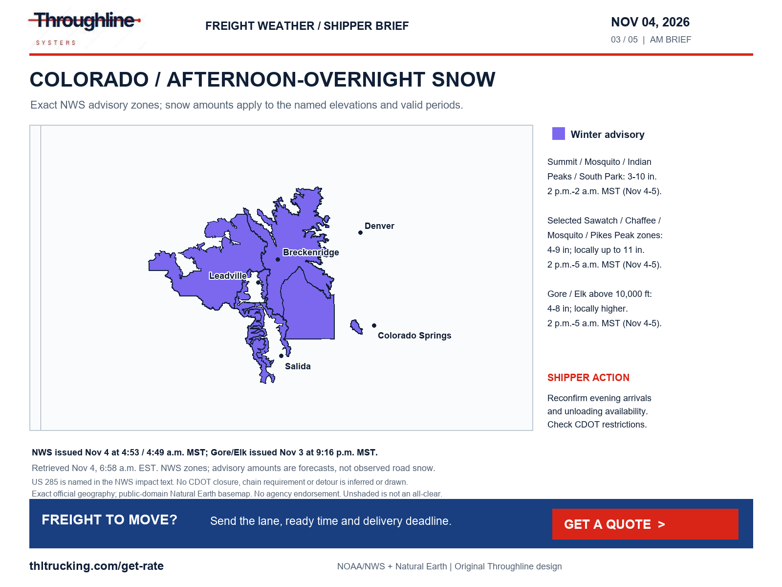
Sources: NWS Winter Weather Advisory: South and Southeast Grand/West Central and Southwest Boulder/Gilpin/Clear Creek/Summit/North and West Park Counties Above 9000 Feet; Central and Southeast Park County; NWS Winter Weather Advisory: Western Mosquito Range/East Lake County Above 11000 Ft; Eastern Sawatch Mountains above 11000 Ft; Western Chaffee County Between 9000 and 11000 Ft; Western Mosquito Range/East Chaffee County above 9000Ft; Pikes Peak above 11000 Ft; NWS Winter Weather Advisory: Gore and Elk Mountains/Central Mountain Valleys; WPC heavy snow and icing discussion; CDOT COtrip road conditions
Wind: eastern Tennessee, the Alaska Range and a separate California transport advisory
NWS’s 1:29 a.m. EST November 4 advisory forecasts southeast winds of 15–25 mph with gusts to 55 mph in eastern Tennessee mountain and foothill zones through 7 p.m. EST. In the eastern Alaska Range north of Trims Camp, an advisory issued November 3 at 7:58 a.m. AKST forecasts south winds of 30–45 mph with gusts to 65 mph from 6 a.m. to 6 p.m. AKST November 4. These are weather advisories; neither establishes a vehicle restriction.
The Mojave Desert Slopes advisory, issued November 3 at 8:39 p.m. PST, remains valid through 6 a.m. PST November 4, forecasting west winds of 15–25 mph and gusts to 45 mph. NWS names SR 14, SR 58, SR 178 and US 395 as potentially affected corridors. The SR 58 overturned-truck lane incident below is separately confirmed by Caltrans; the wind advisory does not establish its cause.
Separately, Caltrans’ SR 99 report, as of November 4 at 4:01 a.m. on its unlabeled local clock, carries a high-wind advisory from the Stanislaus/San Joaquin county line to the San Joaquin/Sacramento county line. Caltrans says travel is not recommended for campers, trailers or permit loads. That is an agency travel advisory, not a confirmed highway closure. Have the carrier evaluate the actual equipment and current official notice before confirming the delivery plan.
For exposed lumber, machinery or building-material loading, confirm the site’s weather-stop procedure and a reachable receiving contact. Strong winds can affect handling as well as transit; this briefing does not assign a universal operating threshold or promise a detour.
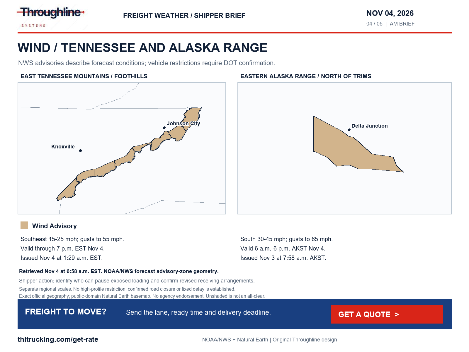
Sources: NWS Wind Advisory: Johnson; Cocke Smoky Mountains; Southeast Greene; Unicoi; Southeast Carter; Blount Smoky Mountains; Sevier Smoky Mountains; Southeast Monroe; NWS Wind Advisory: Eastern Alaska Range North of Trims Camp; Caltrans SR 99 road conditions; NWS Wind Advisory: Mojave Desert Slopes
Morning fog: check the first receiving window
NWS’s 5:59 a.m. EST advisory covers central North Carolina except the far northwest Piedmont through 9 a.m. EST November 4, with visibility of one-quarter mile or less. In southern Oregon’s Klamath Basin, the 3:57 a.m. PST freezing-fog advisory runs through 9 a.m. PST, with visibility below one-quarter mile. Fog and freezing fog are different hazards; check both the approach visibility and the receiving surface before releasing freight.
Other selected NWS fog advisories cover California’s San Joaquin Valley and nearby foothills (issued November 3 at 8:39 p.m. PST; valid midnight–10 a.m. PST November 4); central North Dakota (issued November 4 at 5:19 a.m. CST) and northeastern North Dakota (issued November 3 at 8:49 p.m. CST), both through 10 a.m. CST November 4; Benton/Linn/Lane lowlands in Oregon (issued 3:39 a.m. PST November 4; through 10 a.m. PST); southeastern Louisiana/southern Mississippi (issued 4:44 a.m. CST November 4; through 9 a.m. CST); and portions of coastal Alabama/southeastern Mississippi (issued 2:57 a.m. CST November 4; through 8 a.m. CST). These are selected advisory areas, not whole-state restrictions.
Caltrans separately reports a dense-fog advisory on SR 99 between the Fresno/Merced and Merced/Stanislaus county lines in its 4:01 a.m. November 4 report. Ask for a refreshed arrival estimate and confirm whether the consignee can accept a changed window. Do not convert a visibility forecast into an invented delay duration.
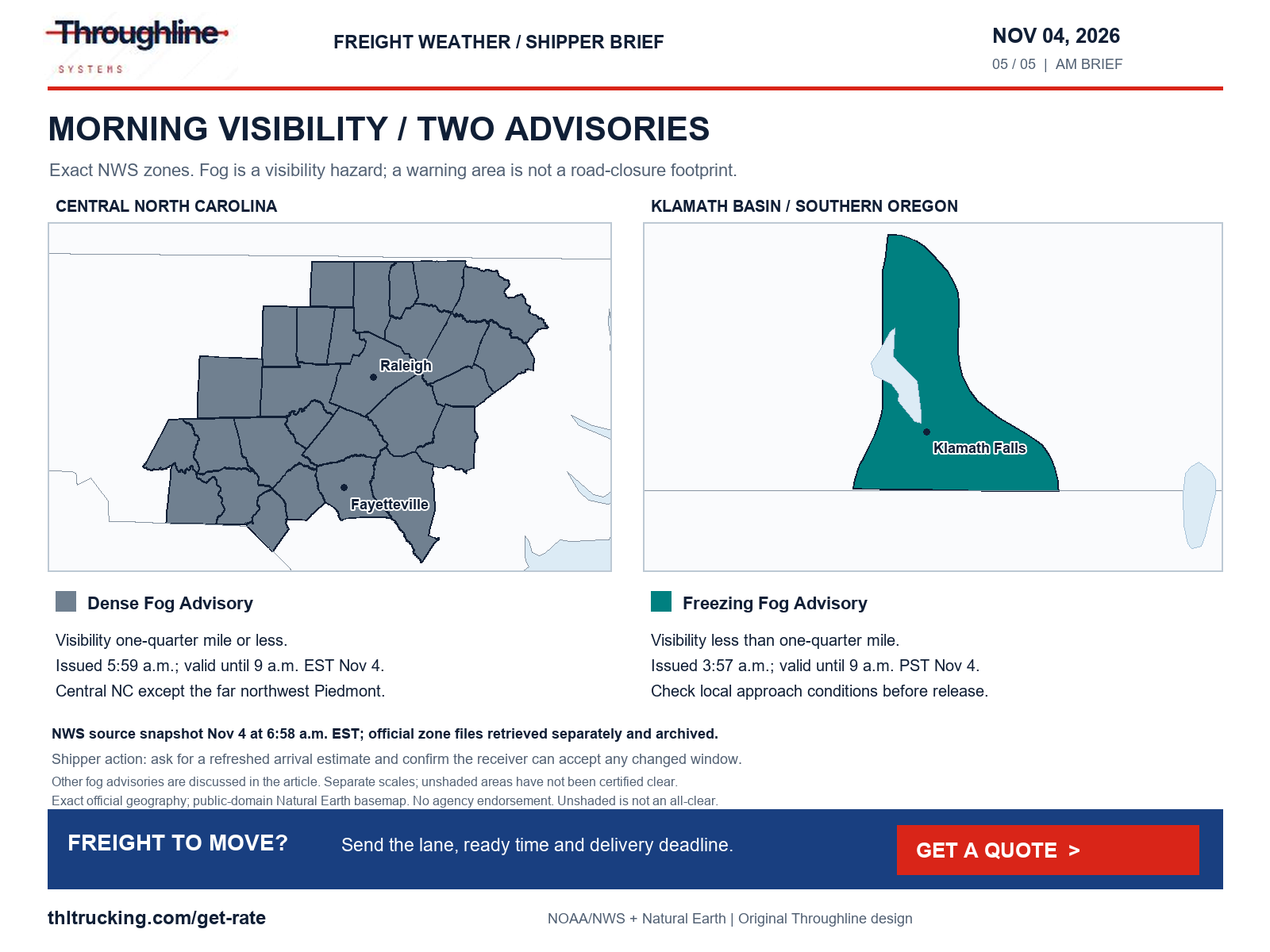
Sources: NWS Dense Fog Advisory: Person; Granville; Vance; Warren; Halifax; Alamance; Orange; Durham; Franklin; Nash; Edgecombe; Randolph; Chatham; Wake; Johnston; Wilson; Stanly; Montgomery; Moore; Lee; Harnett; Wayne; Anson; Richmond; Scotland; Hoke; Cumberland; Sampson; NWS Freezing Fog Advisory: Klamath Basin; NWS national active-alert snapshot; Caltrans SR 99 road conditions
Confirmed road reports: flooding, a truck crash, debris and construction
The following are transport-agency reports retrieved November 4, about 6:58–7:02 a.m. EST. A report can remain published after its last update; recheck it before dispatch. Where the source clock has no time-zone label, the time is reproduced without inventing one. None of these reports supports a nationwide disruption claim.
| Place and source | Reported status and source time | Shipper action |
|---|---|---|
| SR 78, Okeechobee County, Florida — FL511 | All lanes closed in both directions, SW 16th Avenue to US 441, due to flooding; updated November 3, 12:45 p.m. | Confirm the facility approach and appointment with the carrier and receiver. |
| SR 163, southeast Utah — UDOT | Flood closure between MP 41 at US 191 south of Bluff and MP 25 at SR 261; updated November 3, 11:32 a.m. | Have the carrier verify an appropriate current access plan before release. |
| Westbound SR 58, Kern County, California — Caltrans | Traffic reduced to one lane 10–11 miles west of Tehachapi due to an overturned truck; report as of November 4, 3:59 a.m. | Recheck the incident and arrival estimate; no reopening time is established here. |
| Southbound I-75 at Schaefer, Wayne County, Michigan — MDOT | Crash affecting left and center lanes and left shoulder; feed displays 6:55 a.m. without a report date or time zone. Retrieved November 4 at 6:58 a.m. EST. | Confirm current lane status before relying on the morning arrival estimate. |
| Westbound I-696 at Dequindre, Macomb County, Michigan — MDOT | Debris affecting the left lane; feed displays 6:56 a.m. without a report date or time zone. Retrieved November 4 at 6:58 a.m. EST. | Treat as a lane incident, not a full freeway closure. |
| SR 111/Edgewood Avenue near US 90/W Beaver Street, Jacksonville — FL511 | Railroad crossing closed for scheduled construction through November 20; updated November 4, 6:57 a.m. | Confirm the truck approach to affected facilities; no rail-service outage is inferred. |
| I-25 at MP 41, Hatch, New Mexico — NMDOT | Feed lists a closure in both directions; event updated November 3 at 2:26:12 p.m. MST. Detailed cause and vehicle-impact field are unavailable. | Require current NMDOT/carrier confirmation of the precise affected movement before routing. |
| I-80 Exit 214, Rawlins, Wyoming — WYDOT | Higley Boulevard overpass remains listed closed for bridge damage in the November 3, 6:53 p.m. report; this is an aging report. | Verify local access. This does not establish an I-80 mainline closure. |
Sources: FDOT FL511 alerts; UDOT traffic alerts; Caltrans SR 58 road conditions; MDOT Mi Drive incident feed; NMDOT public road-event feed; WYDOT I-80 road-condition report
Flood recovery and Alaska winter conditions need separate checks
A central/east-central Nebraska flood warning issued at 5:32 a.m. CST November 4 remains valid until 3 p.m. CST for parts of Merrick, Nance, Polk, York, Hamilton, Clay and Fillmore counties. NWS describes continuing low-lying and small-stream flooding after Monday–Tuesday rainfall. This supports checking rural approaches and yard access; our Nebraska 511 retrieval did not independently verify a named road closure.
Alaska’s Klondike Highway/White Pass area has an advisory issued at 2:35 a.m. AKST November 4 through 6 a.m. AKST, with up to 5 inches of event-total snow above roughly 1,800 feet. Along parts of the Arctic coast, an advisory issued at 8:36 a.m. AKST November 3 covers midnight November 4 through 3 p.m. November 6 AKST: up to 2 inches total snow, gusts of 35–50 mph and blowing-snow visibility below one-half mile. Possible blizzard conditions are forecast language, not an observed blizzard or confirmed road closure.
The national alert scan also found continuing Southwest and Florida flood warnings. The road table names only the transport reports independently retrieved. NWS hazard geography and transport-closure geography must remain separate.
Sources: NWS Flood Warning: Clay, NE; Fillmore, NE; Hamilton, NE; Merrick, NE; Nance, NE; Polk, NE; York, NE; NWS Winter Weather Advisory: Municipality of Skagway; NWS Winter Weather Advisory: Northern Arctic Coast; Central Beaufort Sea Coast; Eastern Beaufort Sea Coast; NWS national active-alert snapshot
Port planning: the Vincent Thomas Bridge closure starts November 7
Caltrans’ October 22 announcement schedules a 16-month closure of the Vincent Thomas Bridge, SR 47 in San Pedro, beginning Saturday, November 7 at 12:01 a.m. The release does not label the clock’s time zone. The target reopening is early March 2028; the Port of Los Angeles project page reconfirms the planned start. This is a future bridge closure, not a closure of the port complex.
For manufacturers and distributors with port-linked freight, reconfirm the terminal, gate appointment and truck-appropriate approach with the drayage provider before agreeing to the next inland pickup. Caltrans identifies primary detour corridors, but this briefing does not certify a particular truck route or assign a fixed delay.
A separate SR 47 road report as of November 4 at 4:01 a.m. lists nightly northbound construction closure from Harbor Boulevard to Ferry Street, 10:45 p.m.–6:45 a.m., Sunday through Friday through November 6. Keep that current overnight work distinct from the November 7 long-term bridge closure.
Sources: Caltrans: Vincent Thomas Bridge closure begins November 7; Port of Los Angeles: Vincent Thomas Bridge deck replacement; Caltrans SR 47 road conditions
Turn the update into a shipment decision
For FTL and partial freight, confirm when the cargo is actually ready, whether all pieces can travel together, and which delivery deadline is firm. For open-deck equipment, add loading method, dimensions, weight and protection requirements; weather can change when exposed loading is practical. For enclosed equipment, confirm dock or ground-unloading arrangements at both ends.
If a small urgent production component may fit an expedited sprinter service, provide its packed dimensions, weight and handling needs and ask the provider to confirm fit and availability. Faster service does not remove weather restrictions, loading constraints or receiving-hour limits.
Use the contextual Get a quote action with the lane, freight details, ready time and delivery requirement. Include any known facility-access issue and a contact who can approve an appointment change. A quote request is not a capacity or delivery guarantee.
Coverage limits and graphic provenance
This review checked national NWS alerts, SPC severe and fire-weather outlooks, WPC rainfall/winter products and selected official transport sources in California, Colorado, Florida, Michigan, Utah, Wyoming, New Mexico, Nebraska, North Dakota, Tennessee, Oregon, Washington, Minnesota, Montana, Wisconsin, North Carolina and Alaska. It explicitly assessed wind, thunderstorms/damaging wind/hail/tornado risk, snow/blowing snow/blizzard/freezing rain/sleet/ice, flooding, fog, smoke, dust and surface/visibility hazards, plus independent crashes, debris, construction, bridge damage, slides, washouts and wildfire closures.
No Dust or Smoke advisory was identified in the national alert snapshot. SPC’s 05:59 UTC fire-weather outlook lists no critical areas for November 4–5; that does not rule out active fires or local smoke. Several state 511 pages returned only application shells, Oregon’s requested conditions page returned a not-found page, and the retrieved Washington pass records lacked a usable current report date. No current route clearance is claimed for those gaps. National wildfire incident-report coverage could not be verified in this review.
The five graphics use current official forecast polygons or NWS zone boundaries, public-domain Natural Earth geography and the approved Throughline wordmark in an original layout. Alaska and Hawaii national insets have separate scales and limited hazard-layer coverage. Cities are reference locations, not plotted truck routes. Unshaded areas are not an all-clear, and source credit does not imply agency endorsement. Source files, timestamps, coverage gaps and asset provenance are archived with this briefing.
Sources: NWS national active-alert snapshot; SPC Day 1 convective outlook; WPC excessive rainfall discussion; WPC heavy snow and icing discussion; SPC Day 1 fire-weather outlook; Natural Earth public-domain terms
Sources and editorial notes
Original analysis by Throughline Systems. Source links may show newer releases after this article’s publication; the observation and issue dates below identify the material used. Agency citations do not imply endorsement.
- EIA gasoline and diesel fuel update
Released November 3, 2026; diesel observations November 2 versus October 26; USD per US gallon, including taxes
Accessed .
- SPC Day 1 convective outlook
Issued 05:34 UTC November 4; valid 12:00 UTC November 4–12:00 UTC November 5, 2026
Accessed .
- WPC excessive rainfall discussion
Issued 3:10 a.m. EST November 4; Day 1 valid 12:00 UTC November 4–12:00 UTC November 5, 2026
Accessed .
- WPC heavy snow and icing discussion
Issued 2:17 a.m. EST November 4; valid 12:00 UTC November 4–12:00 UTC November 7, 2026
Accessed .
- NWS Winter Weather Advisory: South and Southeast Grand/West Central and Southwest Boulder/Gilpin/Clear Creek/Summit/North and West Park Counties Above 9000 Feet; Central and Southeast Park County
Issued 2026-11-04T04:53:00-07:00; valid through 2026-11-05T02:00:00-07:00
Accessed .
- NWS Winter Weather Advisory: Western Mosquito Range/East Lake County Above 11000 Ft; Eastern Sawatch Mountains above 11000 Ft; Western Chaffee County Between 9000 and 11000 Ft; Western Mosquito Range/East Chaffee County above 9000Ft; Pikes Peak above 11000 Ft
Issued 2026-11-04T04:49:00-07:00; valid through 2026-11-05T05:00:00-07:00
Accessed .
- NWS Winter Weather Advisory: Gore and Elk Mountains/Central Mountain Valleys
Issued 2026-11-03T21:16:00-07:00; valid through 2026-11-05T05:00:00-07:00
Accessed .
- NWS Wind Advisory: Johnson; Cocke Smoky Mountains; Southeast Greene; Unicoi; Southeast Carter; Blount Smoky Mountains; Sevier Smoky Mountains; Southeast Monroe
Issued 2026-11-04T01:29:00-05:00; valid through 2026-11-04T19:00:00-05:00
Accessed .
- NWS Wind Advisory: Eastern Alaska Range North of Trims Camp
Issued 2026-11-03T07:58:00-09:00; valid through 2026-11-04T18:00:00-09:00
Accessed .
- NWS Dense Fog Advisory: Person; Granville; Vance; Warren; Halifax; Alamance; Orange; Durham; Franklin; Nash; Edgecombe; Randolph; Chatham; Wake; Johnston; Wilson; Stanly; Montgomery; Moore; Lee; Harnett; Wayne; Anson; Richmond; Scotland; Hoke; Cumberland; Sampson
Issued 2026-11-04T05:59:00-05:00; valid through 2026-11-04T09:00:00-05:00
Accessed .
- NWS Freezing Fog Advisory: Klamath Basin
Issued 2026-11-04T03:57:00-08:00; valid through 2026-11-04T09:00:00-08:00
Accessed .
- NWS Flood Warning: Clay, NE; Fillmore, NE; Hamilton, NE; Merrick, NE; Nance, NE; Polk, NE; York, NE
Issued 2026-11-04T05:32:00-06:00; valid through 2026-11-04T15:00:00-06:00
Accessed .
- NWS Winter Weather Advisory: Municipality of Skagway
Issued 2026-11-04T02:35:00-09:00; valid through 2026-11-04T06:00:00-09:00
Accessed .
- NWS Winter Weather Advisory: Northern Arctic Coast; Central Beaufort Sea Coast; Eastern Beaufort Sea Coast
Issued 2026-11-03T08:36:00-09:00; valid through 2026-11-06T15:00:00-09:00
Accessed .
- NWS national active-alert snapshot
National snapshot retrieved November 4, 2026 at 6:58 a.m. EST; each alert has its own issue and valid period
Accessed .
- CDOT COtrip road conditions
Live site checked November 4; retrieved page did not expose a usable current restriction list
Accessed .
- FDOT FL511 alerts
SR-78 updated November 3 at 12:45 p.m.; SR-111 updated November 4 at 6:57 a.m.; displayed time zones unlabeled
Accessed .
- UDOT traffic alerts
SR-163 flood closure updated November 3, 2026 at 11:32 a.m.; displayed time zone unlabeled
Accessed .
- Caltrans SR 58 road conditions
Page as of November 4, 2026 at 3:59 a.m.; displayed time zone unlabeled
Accessed .
- Caltrans SR 99 road conditions
Page as of November 4, 2026 at 4:01 a.m.; displayed time zone unlabeled
Accessed .
- Caltrans SR 47 road conditions
Page as of November 4, 2026 at 4:01 a.m.; displayed time zone unlabeled
Accessed .
- MDOT Mi Drive incident feed
Feed displays 6:55 and 6:56 a.m. without a report date or time-zone label; retrieved November 4, 2026 at 6:58 a.m. EST
Accessed .
- NMDOT public road-event feed
Event-level updates used; generic feed metadata still dated 2020 and does not establish event freshness
Accessed .
- WYDOT I-80 road-condition report
Page report November 3, 2026 at 6:53 p.m.; an older report retrieved again November 4
Accessed .
- Caltrans: Vincent Thomas Bridge closure begins November 7
Released October 22, 2026; planned closure begins November 7 at 12:01 a.m.; announcement does not label time zone
Accessed .
- Port of Los Angeles: Vincent Thomas Bridge deck replacement
Undated project page, rechecked November 4, 2026
Accessed .
- SPC Day 1 fire-weather outlook
Issued 05:59 UTC November 4; valid 12:00 UTC November 4–12:00 UTC November 5, 2026
Accessed .
- Natural Earth public-domain terms
Public-domain map-data terms rechecked November 4, 2026
Accessed .
- NWS Wind Advisory: Mojave Desert Slopes
Issued 2026-11-03T20:39:00-08:00; valid through 2026-11-04T06:00:00-08:00
Accessed .