November 7 logistics briefing: weekend wind, Texas rain and freight-access checks
November 7 shipper briefing: Washington and Montana wind, Texas weekend rain, Cascades snow, official road closures and latest weekly diesel at $6.292.
By Throughline Systems · · 13 min read
What matters for your next load
- Confirm weekend loading and receiving contacts before releasing freight into Washington wind or South Texas rain risk.
- Separate Cascades snow and morning freezing-fog forecasts from DOT-confirmed construction, crash and bridge restrictions.
- Latest diesel remains the November 2 weekly value; verify port access against current official reports.
Saturday priorities: protect the pickup and receiving handoff
Research snapshot: November 7, 2026, approximately 7:06–7:08 a.m. EST. The weekend planning issue is regional: South Texas rainfall risk increases into Sunday, Washington has evening wind warnings and advisories, Montana has separate morning and Sunday wind periods, and Washington Cascades snow is forecast tonight into Sunday. Official road reports also identify closures from construction, crashes, bridge damage and flooding.
For manufacturers, lumber suppliers and distributors releasing a weekend shipment, verify three things before the truck is committed: the actual site approach, the loading crew and equipment, and a receiver contact who can change the appointment. The forecast does not establish a road closure or a predictable delay. A quiet severe-weather outlook does not remove these other risks.
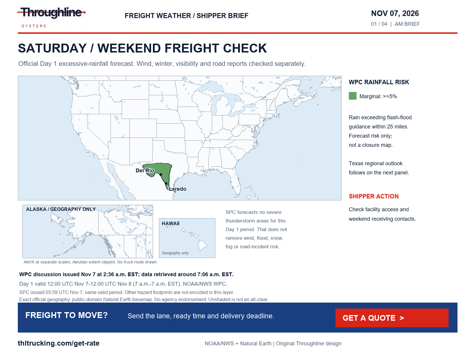
Sources: SPC Day 1 convective outlook; WPC excessive-rainfall discussion; NWS national active-alert snapshot; UDOT official alerts
Latest diesel remains the November 2 weekly observation
EIA’s November 3 release remains the latest available update: U.S. on-highway diesel averaged $6.292 per US gallon for November 2, including taxes. That is $0.060 below the October 26 value of $6.352. EIA lists November 10 as the next scheduled release. There is no new daily diesel observation in this briefing.
Compare quotes using the same shipment scope and fuel-index basis. A weekly national fuel average is a budgeting reference, not the price of a particular FTL, partial, enclosed, open-deck or expedited sprinter move. Ask which fuel week and surcharge treatment apply before comparing totals.
| Measure | Latest verified value |
|---|---|
| U.S. on-highway diesel, November 2 | $6.292 per US gallon, taxes included |
| Previous observation, October 26 | $6.352 per US gallon |
| Weekly change | Down $0.060 per US gallon |
| Release / next scheduled release | November 3 / November 10, 2026 |
Sources: EIA on-highway diesel update
South Texas: distinguish the Saturday forecast from the stronger Sunday outlook
WPC’s 2:36 a.m. EST discussion assigns a Marginal excessive-rainfall risk to parts of South, Central and West Texas for 12:00 UTC November 7–12:00 UTC November 8. Its Day 2 outlook raises South-central and South Texas to a Slight risk for 12:00 UTC November 8–12:00 UTC November 9. These categories describe forecast rainfall exceeding flash-flood guidance within 25 miles; they are not a list of flooded highways.
The NWS South Texas Flood Watch, issued 8:17 p.m. CST November 6, runs from noon CST November 7 through noon CST November 9 and includes Webb, Duval, La Salle, Nueces and other listed counties and coastal zones. It forecasts widespread 2–4 inches over that event, with locally higher totals possible. For freight into the Laredo, Corpus Christi and surrounding distribution areas, confirm low-lying facility approaches and an alternate receiving contact. DriveTexas was checked, but the retrieved application shell did not provide a complete incident list; this review does not confirm a Texas highway closure.
In the Northeast, the separate flood watch for Rhode Island and southeastern Massachusetts remains valid through 10 a.m. EST November 7 in the retrieved snapshot, issued 2:30 p.m. EST November 6. Confirm drainage and dock access with the facility rather than assuming overnight rain has cleared.
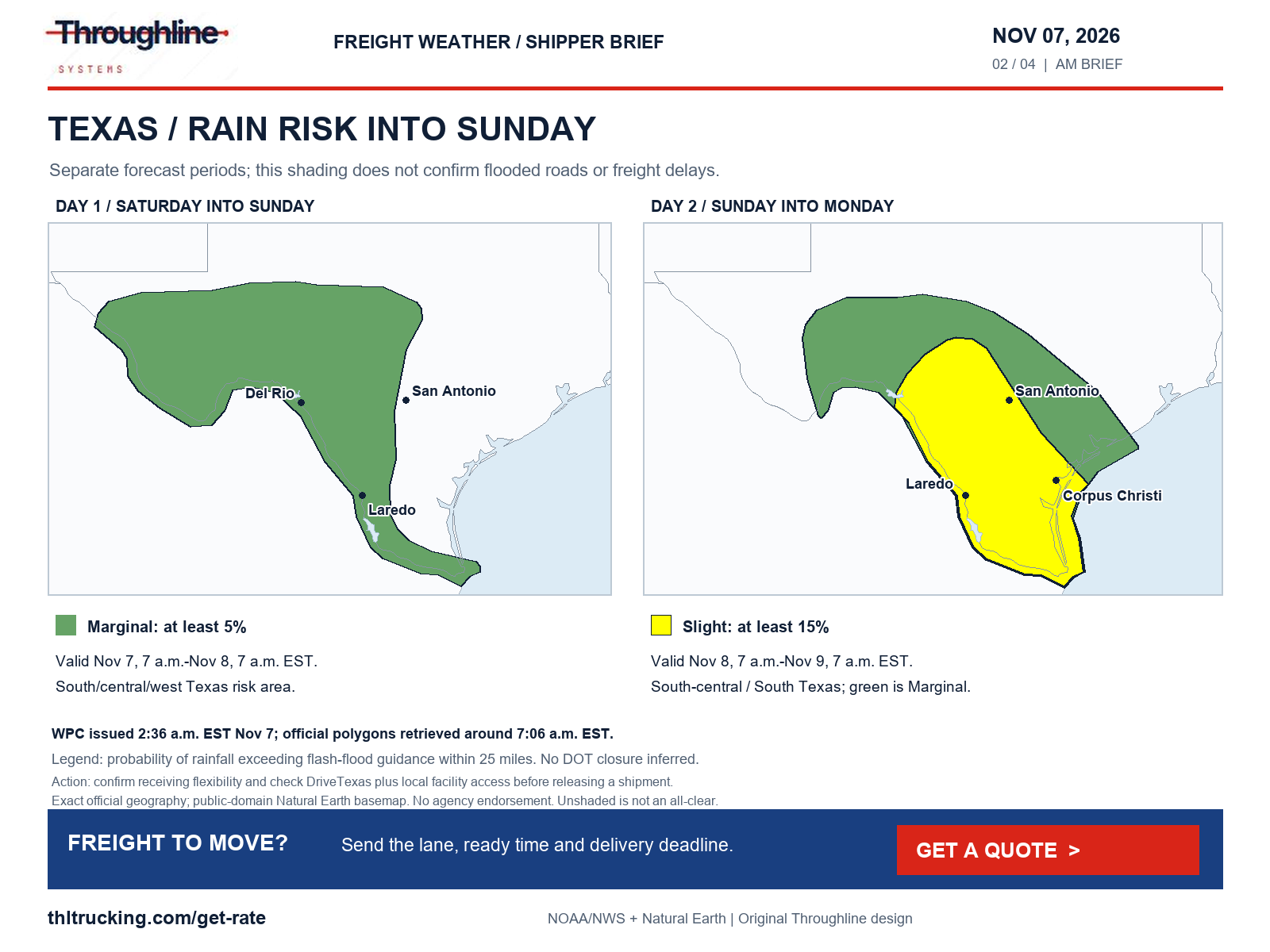
Sources: WPC excessive-rainfall discussion; NWS Flood Watch: La Salle; McMullen; Live Oak; Bee; Goliad; Webb; Duval; Jim Wells; Inland Kleberg; Inland Nueces; Inland San Patricio; Coastal Aransas; Inland Refugio; Coastal Kleberg; Coastal Nueces; Coastal San Patricio; Aransas Islands; Coastal Refugio; Kleberg Islands; Nueces Islands; TxDOT DriveTexas; NWS Flood Watch: Northern Bristol; Western Plymouth; Eastern Plymouth; Southern Bristol; Southern Plymouth; Barnstable; Dukes; Northwest Providence; Southeast Providence; Western Kent; Eastern Kent; Bristol; Washington; Newport; Block Island
Washington and Montana: loading exposure matters as much as transit
Washington’s coastal High Wind Warning, issued 2:02 a.m. PST November 7, forecasts south winds of 25–35 mph with gusts to 60 mph from 4 p.m. November 7 through 4 a.m. November 8 PST for the northern coast and Grays Harbor coast. Separate western Washington advisories forecast gusts to 50 mph from 4 p.m.–4 a.m.; the Puget Sound and northern lowland advisory forecasts gusts to 45 mph from 6 p.m.–4 a.m. These are different zones and periods.
Montana’s 2:53 a.m. MST November 7 warning covers East Glacier and the adjacent northern/southern high plains with gusts to 70 mph through 9 a.m. MST. The same bulletin describes a second warning for 9 a.m.–8 p.m. MST Sunday with gusts to 80 mph. Eastern Toole/Liberty has a morning warning and separate Sunday watch; Hill County and Cascade County below 5,000 feet have a Sunday watch. Southwest Phillips has a warning through 9 a.m. MST November 7, issued 10:28 p.m. MST November 6, for gusts to 60 mph. Oregon’s Grande Ronde Valley advisory forecasts gusts to 40 mph from 9 a.m.–8 p.m. PST November 7.
For open-deck freight, confirm whether the pickup can safely stage and load under its own procedures and whether packaging is ready before arrival. For enclosed trailers and sprinters, ask the carrier to reassess operating conditions and the receiver to confirm power and access. None of these NWS products establishes a high-profile vehicle restriction; no such restriction is inferred here.
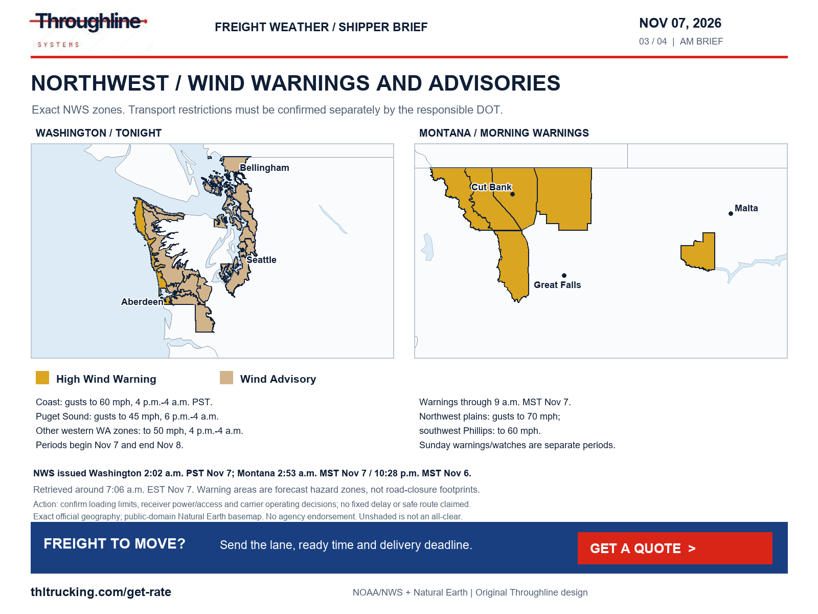
Sources: NWS High Wind Warning: Northern Washington Coast; Grays Harbor County Coast; NWS Wind Advisory: Middle Chehalis River Valley; Willapa and Black Hills; Western Strait of Juan de Fuca; Lake Crescent Area Including US 101; Foothills of the Western and Southern Olympic Peninsula; Lower Chehalis River Valley; NWS Wind Advisory: San Juan County; Lowlands of Western Whatcom County; Lowlands of Western Skagit and Northwestern Snohomish Counties; Downtown Everett / Marysville Area; Shoreline / Lynnwood / South Everett Area; Eastside; City of Seattle; Lowlands of Pierce and Southern King Counties; Port Townsend Area; Island County; NWS High Wind Warning: East Glacier Park Region; Northern High Plains; Eastern Glacier, Western Toole, and Central Pondera; Southern High Plains; NWS High Wind Warning: Eastern Toole and Liberty; NWS High Wind Warning: Southwest Phillips; NWS High Wind Watch: Hill County; Cascade County below 5000ft; NWS Wind Advisory: Grande Ronde Valley
Cascades snow and morning freezing fog need separate checks
WPC’s 1:48 a.m. EST November 7 winter discussion covers 12:00 UTC November 7–12:00 UTC November 10. For the Washington Cascades during Days 1–2, it forecasts snow levels falling from above 7,000 feet Saturday afternoon to about 4,000–5,000 feet Sunday morning. At Washington Pass on SR 20, it gives about a 50% probability of at least 4 inches and about 30% of at least 6 inches over that Day 1–2 period. The retrieved WSDOT page did not expose usable current restrictions, so pass opening, chains and highway status remain to be checked with WSDOT before movement.
WPC puts the probability of significant ice across the contiguous U.S. below 10% for its forecast period. That does not rule out local icing: NWS dense-fog advisories for parts of South Dakota, issued 4:36 a.m. CST November 7 and valid until 9 a.m., explicitly mention possible freezing fog and light icing. The north-central Kansas/south-central Nebraska advisory issued 4:19 a.m. CST and valid until 10 a.m. also mentions possible slick spots from freezing fog.
Dense fog also appears in the national scan over parts of Oklahoma, Kansas and Washington’s Kittitas Valley/eastern Cascades slopes. The Oklahoma/Grady advisory issued 5:41 a.m. CST runs until 10 a.m.; the Kittitas advisory issued 2:54 a.m. PST runs until 11 a.m. Both forecast visibility at or below one-quarter mile. For first appointments, ask for a fresh carrier ETA and keep the unloading crew informed rather than setting an unsupported delay allowance.
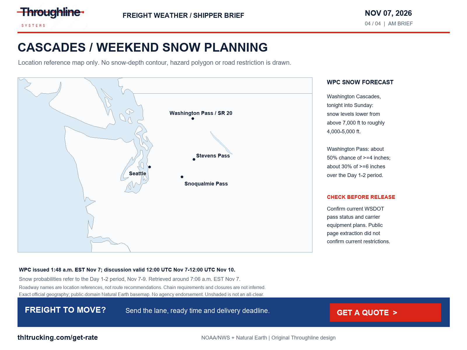
Sources: WPC heavy snow and icing discussion; WSDOT North Cascades Highway status page; NWS Dense Fog Advisory: Spink; Hyde; Hand; Buffalo; NWS Dense Fog Advisory: Phillips; Smith; Jewell; Rooks; Osborne; Mitchell; Gosper; Phelps; Furnas; Harlan; Franklin; Webster; NWS Dense Fog Advisory: Oklahoma; Grady; NWS Dense Fog Advisory: Kittitas Valley; Lower Slopes of the Eastern Washington Cascades Crest
Road restrictions: construction and damage matter without a weather trigger
UDOT’s retrieved alerts report westbound I-84 closed for a bridge move, beginning 10 p.m. November 6 with reopening expected 6 a.m. November 9; the alert was updated November 6 at 6:28 p.m. It also continues to list SR-163 closed between mileposts 41 and 25 because of flooding, updated November 5 at 4:56 a.m. The page does not label those time zones. Confirm the current restriction and a carrier-approved approach before releasing a shipment; an expected reopening is not a confirmation that work is finished.
FDOT FL511 reports an eastbound US-192 crash at US-17/92/John Young Parkway in Osceola County with all lanes blocked, updated November 7 at 7:06 a.m. Its Jacksonville notice says the Edgewood Avenue/SR-111 railroad crossing near US-90 remains closed for scheduled work until November 20, updated at 5:19 a.m. Displayed time zones are unlabeled. These are official road reports, not impacts inferred from a weather map.
WYDOT’s I-80 page, last updated November 7 at 4:27 a.m. with time zone unlabeled, lists the Higley Boulevard overpass at exit 214 near Rawlins closed because of bridge damage. That is an overpass closure, not a statement that the I-80 mainline is closed. The same page reports strong winds on the Wagonhound–Arlington–Cooper Cove segments without listing a restriction in those rows at retrieval. Check again before dispatch; conditions can change after a snapshot.
Sources: UDOT official alerts; FDOT FL511 official alerts; WYDOT I-80 conditions
Port-access planning: the November 7 bridge project needs a live approach check
The Port of Los Angeles project page still identifies November 7 as the start of the Vincent Thomas Bridge deck replacement and the associated long closure of SR 47. The undated project page says terminals will remain open. This is a port-access planning issue, not evidence that the port is shut down or that every load will be delayed.
There is an important verification limit: Caltrans’ SR 47 condition report at 4:06 a.m. November 7 says no traffic restrictions are reported for that area, while the Port project page gives the November 7 planned start. Because these official sources do not establish the same live status, this briefing does not certify that the bridge is currently closed or open. Confirm the current Caltrans restriction, terminal gate and carrier approach before a port-related pickup; adjust the receiving appointment only against that verified plan.
Sources: Port of Los Angeles Vincent Thomas Bridge project; Caltrans SR 47 road conditions
Fire weather and existing river flooding are additional local access checks
The NWS Red Flag Warning for Santa Clarita Valley and listed Los Angeles-area mountain zones is valid 2 a.m.–6 p.m. PST November 7, issued 3:14 p.m. PST November 6. It forecasts northeast winds of 20–30 mph with gusts to 45 mph, with stronger isolated gusts in favored locations. This warns about fire-growth conditions if ignition occurs; it does not confirm a wildfire, smoke plume or road closure.
The national alert snapshot also contains ongoing river-flood warnings in Arizona and Florida, including the Salt/Gila system in Maricopa County and the Peace River at Arcadia in DeSoto County. These products describe local river flooding and forecast thresholds, not a blanket closure of regional freight routes. Confirm low-water crossings and facility access with the responsible local authority. No verified freight-impacting smoke or dust incident was established in the sources retrieved for this review.
Sources: NWS Red Flag Warning: Santa Clarita Valley; Western Santa Monica Mountains Recreational Area; Eastern Santa Monica Mountains Recreational Area; Santa Susana Mountains; Western San Gabriel Mountains and Highway 14 Corridor; NWS Flood Warning: Maricopa, AZ; NWS Flood Warning: DeSoto, FL
Before releasing an FTL, partial or urgent shipment
For an open-deck load, provide the actual dimensions, weight, packaging, weather-protection requirements and loading method. Confirm whether the pickup can load in the forecast conditions and whether the receiver can unload the same equipment. For enclosed freight, verify dock access and the receiver’s appointment window; an enclosed trailer does not resolve access-road flooding or wind exposure.
For a partial shipment, make the delivery constraint explicit and verify how it fits the proposed service before booking. For urgent production parts that may fit a sprinter, send piece dimensions, weight and loading/unloading requirements along with the actual production deadline. Do not choose equipment on urgency alone.
Throughline’s public quote path can start the conversation with the lane and shipment details. Keep pickup readiness, delivery deadlines and unusual access conditions in the request so the quote can be evaluated against the job that actually needs to move.
Coverage and limits of this morning’s review
The national check covered NWS active alerts, SPC severe-weather and fire-weather products, and WPC excessive-rainfall, winter and short-range discussions. Wind, severe thunderstorms including damaging wind/hail/tornado risk, snow/blowing snow/blizzard, freezing rain/sleet/ice, flooding, fog, smoke/dust and other visibility/surface hazards were assessed. SPC forecast no severe-thunderstorm areas for its Day 1 period; that finding is limited to that product and valid period. No blizzard or winter-weather advisory/warning appeared in the retrieved national active-alert event categories; WPC nevertheless forecasts Cascades snow.
Road checks included official Utah, Florida, Wyoming, California, Michigan, New Jersey, Washington, Oregon, Texas, Minnesota, Wisconsin, North Carolina, Colorado, Montana, Alaska, New Mexico, Nebraska and North Dakota sources. Several portals returned application shells or incomplete data. Washington pass reports and DriveTexas did not yield a usable complete restriction list, and BNSF retrieval failed. Michigan’s incident feed returned an empty list at retrieval; that is not proof every Michigan road was clear. The review is selective and cannot certify all U.S. roads or every crash, construction zone, debris/rockslide, washout, wildfire or bridge restriction.
The maps are original Throughline layouts using current official forecast/zone data and public-domain Natural Earth geography. Hazard colors retain source meanings. Alaska and Hawaii insets disclose their geography-only coverage; the Cascades panel is explicitly a location reference. No commercial weather artwork, fabricated radar, artificial hazard polygon or agency endorsement is used. Recheck official sources and the facility before dispatch.
Sources: NWS national active-alert snapshot; SPC Day 1 convective outlook; WPC heavy snow and icing discussion; WPC excessive-rainfall discussion; Natural Earth public-domain terms
Sources and editorial notes
Original analysis by Throughline Systems. Source links may show newer releases after this article’s publication; the observation and issue dates below identify the material used. Agency citations do not imply endorsement.
- EIA on-highway diesel update
Released November 3, 2026; observation week November 2 versus October 26; USD per US gallon including taxes
Accessed .
- SPC Day 1 convective outlook
Issued 05:59 UTC November 7; valid 12:00 UTC November 7–12:00 UTC November 8, 2026
Accessed .
- WPC excessive-rainfall discussion
Issued 2:36 a.m. EST November 7; Day 1 November 7–8 and Day 2 November 8–9, each 12:00–12:00 UTC
Accessed .
- WPC heavy snow and icing discussion
Issued 1:48 a.m. EST November 7; valid 12:00 UTC November 7–12:00 UTC November 10; Cascades Day 1–2 forecast
Accessed .
- NWS national active-alert snapshot
National snapshot retrieved November 7, 2026 at 12:06 UTC; each alert has individual issue/valid periods
Accessed .
- NWS High Wind Warning: Northern Washington Coast; Grays Harbor County Coast
Issued 2026-11-07T02:02:00-08:00; valid 2026-11-07T16:00:00-08:00 through 2026-11-08T04:00:00-08:00 (alert expiry when no end is supplied)
Accessed .
- NWS Wind Advisory: Middle Chehalis River Valley; Willapa and Black Hills; Western Strait of Juan de Fuca; Lake Crescent Area Including US 101; Foothills of the Western and Southern Olympic Peninsula; Lower Chehalis River Valley
Issued 2026-11-07T02:02:00-08:00; valid 2026-11-07T16:00:00-08:00 through 2026-11-08T04:00:00-08:00 (alert expiry when no end is supplied)
Accessed .
- NWS Wind Advisory: San Juan County; Lowlands of Western Whatcom County; Lowlands of Western Skagit and Northwestern Snohomish Counties; Downtown Everett / Marysville Area; Shoreline / Lynnwood / South Everett Area; Eastside; City of Seattle; Lowlands of Pierce and Southern King Counties; Port Townsend Area; Island County
Issued 2026-11-07T02:02:00-08:00; valid 2026-11-07T18:00:00-08:00 through 2026-11-08T04:00:00-08:00 (alert expiry when no end is supplied)
Accessed .
- NWS High Wind Warning: East Glacier Park Region; Northern High Plains; Eastern Glacier, Western Toole, and Central Pondera; Southern High Plains
Issued 2026-11-07T02:53:00-07:00; valid 2026-11-07T02:53:00-07:00 through 2026-11-07T09:00:00-07:00 (alert expiry when no end is supplied)
Accessed .
- NWS High Wind Warning: Eastern Toole and Liberty
Issued 2026-11-07T02:53:00-07:00; valid 2026-11-07T02:53:00-07:00 through 2026-11-07T09:00:00-07:00 (alert expiry when no end is supplied)
Accessed .
- NWS High Wind Warning: Southwest Phillips
Issued 2026-11-06T22:28:00-07:00; valid 2026-11-07T00:00:00-07:00 through 2026-11-07T09:00:00-07:00 (alert expiry when no end is supplied)
Accessed .
- NWS High Wind Watch: Hill County; Cascade County below 5000ft
Issued 2026-11-07T02:53:00-07:00; valid 2026-11-08T08:00:00-07:00 through 2026-11-08T20:00:00-07:00 (alert expiry when no end is supplied)
Accessed .
- NWS Wind Advisory: Grande Ronde Valley
Issued 2026-11-07T02:54:00-08:00; valid 2026-11-07T09:00:00-08:00 through 2026-11-07T20:00:00-08:00 (alert expiry when no end is supplied)
Accessed .
- NWS Flood Watch: La Salle; McMullen; Live Oak; Bee; Goliad; Webb; Duval; Jim Wells; Inland Kleberg; Inland Nueces; Inland San Patricio; Coastal Aransas; Inland Refugio; Coastal Kleberg; Coastal Nueces; Coastal San Patricio; Aransas Islands; Coastal Refugio; Kleberg Islands; Nueces Islands
Issued 2026-11-06T20:17:00-06:00; valid 2026-11-07T12:00:00-06:00 through 2026-11-09T12:00:00-06:00 (alert expiry when no end is supplied)
Accessed .
- NWS Flood Watch: Northern Bristol; Western Plymouth; Eastern Plymouth; Southern Bristol; Southern Plymouth; Barnstable; Dukes; Northwest Providence; Southeast Providence; Western Kent; Eastern Kent; Bristol; Washington; Newport; Block Island
Issued 2026-11-06T14:30:00-05:00; valid 2026-11-06T14:30:00-05:00 through 2026-11-07T10:00:00-05:00 (alert expiry when no end is supplied)
Accessed .
- NWS Dense Fog Advisory: Spink; Hyde; Hand; Buffalo
Issued 2026-11-07T04:36:00-06:00; valid 2026-11-07T04:36:00-06:00 through 2026-11-07T09:00:00-06:00 (alert expiry when no end is supplied)
Accessed .
- NWS Dense Fog Advisory: Phillips; Smith; Jewell; Rooks; Osborne; Mitchell; Gosper; Phelps; Furnas; Harlan; Franklin; Webster
Issued 2026-11-07T04:19:00-06:00; valid 2026-11-07T04:19:00-06:00 through 2026-11-07T10:00:00-06:00 (alert expiry when no end is supplied)
Accessed .
- NWS Dense Fog Advisory: Oklahoma; Grady
Issued 2026-11-07T05:41:00-06:00; valid 2026-11-07T05:41:00-06:00 through 2026-11-07T10:00:00-06:00 (alert expiry when no end is supplied)
Accessed .
- NWS Dense Fog Advisory: Kittitas Valley; Lower Slopes of the Eastern Washington Cascades Crest
Issued 2026-11-07T02:54:00-08:00; valid 2026-11-07T02:54:00-08:00 through 2026-11-07T11:00:00-08:00 (alert expiry when no end is supplied)
Accessed .
- NWS Red Flag Warning: Santa Clarita Valley; Western Santa Monica Mountains Recreational Area; Eastern Santa Monica Mountains Recreational Area; Santa Susana Mountains; Western San Gabriel Mountains and Highway 14 Corridor
Issued 2026-11-06T15:14:00-08:00; valid 2026-11-07T02:00:00-08:00 through 2026-11-07T18:00:00-08:00 (alert expiry when no end is supplied)
Accessed .
- NWS Flood Warning: Maricopa, AZ
Issued 2026-11-06T21:23:00-07:00; valid 2026-11-06T21:23:00-07:00 through 2026-11-07T11:00:00-07:00 (alert expiry when no end is supplied)
Accessed .
- NWS Flood Warning: DeSoto, FL
Issued 2026-11-06T20:32:00-05:00; valid 2026-11-06T20:32:00-05:00 through 2026-11-07T08:45:00-05:00 (alert expiry when no end is supplied)
Accessed .
- UDOT official alerts
SR-163 flood closure updated November 5 at 4:56 a.m.; westbound I-84 bridge closure updated November 6 at 6:28 p.m.; displayed time zones unlabeled
Accessed .
- FDOT FL511 official alerts
US-192 eastbound crash updated November 7 at 7:06 a.m.; Jacksonville construction updated 5:19 a.m.; displayed time zones unlabeled
Accessed .
- WYDOT I-80 conditions
Page last updated November 7 at 4:27 a.m.; bridge-damage district note has no separate timestamp; displayed time zone unlabeled
Accessed .
- Caltrans SR 47 road conditions
Report as of November 7, 2026 at 4:06 a.m.; displayed time zone unlabeled
Accessed .
- Port of Los Angeles Vincent Thomas Bridge project
Undated official project page; November 7, 2026 planned start rechecked November 7 at 12:07 UTC
Accessed .
- WSDOT North Cascades Highway status page
Retrieved November 7; extraction did not expose a usable current restriction report
Accessed .
- TxDOT DriveTexas
Retrieved November 7; application shell did not expose a complete current incident list
Accessed .
- Natural Earth public-domain terms
Terms rechecked November 7; approved public-domain geographical assets reused with current official forecast data
Accessed .