November 12 briefing: Sierra I-80 snow, Friday wind, Indiana lake-effect snow
November 12 shipper briefing: Sierra I-80 snow, Friday wind on I-5, Nevada I-80 and the Mojave, Indiana lake-effect snow, Gila River flooding, diesel $6.127.
By Throughline Systems · · 9 min read
What matters for your next load
- Before releasing Friday freight over Donner Summit or the Lake Tahoe routes, confirm the pickup time and a receiver contact who can move the appointment; Sierra winter storm warnings run 10 AM Friday to 10 AM PST Saturday.
- Plan empty and high-profile trailers around Friday’s western wind: I-5 through the Shasta Valley and southern Oregon, Nevada I-80 and US-395/I-580, and I-15/I-40 near Barstow.
- Give Friday-morning deliveries through Lake County, Indiana a time buffer for lake-effect snow (midnight to 10 AM CST).
- EIA’s latest weekly diesel average is $6.127 per gallon for November 9, down $0.165; confirm which fuel week a quote uses.
The national picture: a Pacific storm sets up Friday’s trouble in the West
Research snapshot: November 12, 2026 at 6:18 a.m. ET. Of 272 freight hubs and mountain passes rated for the next 36 hours, 1 is high risk (Donner Summit on I-80), 14 are medium and 20 low. One interstate has a high-risk stretch (I-80 from Sacramento over Donner Summit to Reno) and 7 have medium-risk stretches: I-5, I-10, I-15, I-40, I-65, I-84 and I-90. The national alert count is led by high wind (23 alerts) and snow and winter storm products (17), followed by flooding (9) and coastal flooding (6).
Most of the freight risk is in California and Nevada on Friday. NWS Sacramento and NWS Reno have winter storm warnings for the northern Sierra and the Lake Tahoe area from 10 a.m. Friday to 10 a.m. PST Saturday, and wind warnings and advisories run from southern Oregon and the Sacramento Valley to Reno, northern Nevada and the Mojave Desert. Farther south, NWS Hanford has a Winter Storm Watch for the Sierra above 6,000 feet from Friday afternoon through late Monday night. WPC’s Day 1 Winter Storm Severity Index peaks at Moderate in a small area of far northern California; SPC’s Day 1 outlook shows only a Marginal severe-thunderstorm area in the Mid-Atlantic.
East of the Rockies the picture is lighter: lake-effect snow advisories for Lake County, Indiana and for Marquette and Baraga counties in Michigan’s Upper Peninsula, mountain snow advisories in the Adirondacks and southern Vermont (Thursday into Friday morning) and in the Tennessee Smoky Mountains above 3,000 feet (Thursday evening into Saturday morning), and a coastal flood advisory for Ocean County, New Jersey until 2 p.m. EST today. Two morning-only alerts were not made hot spots because they expire early today: a dense fog advisory for the Spokane area, Moses Lake and the Idaho Panhandle until 7 a.m. PST, and a freezing-rain advisory for Anchorage valid until 5 a.m. AKST.
Sources: NWS national active-alert snapshot; SPC Day 1 convective outlook; WPC Winter Storm Severity Index; NWS Winter Storm Warning: Lassen Volcanic National Park and more; NWS Winter Storm Warning: Greater Lake Tahoe Area; NWS Winter Storm Watch: Yosemite, Kings Canyon and Sequoia areas above 6,000 feet; NWS Winter Weather Advisory: Baraga; Marquette; NWS Winter Weather Advisory: Western Essex; Eastern Addison; Eastern Rutland; NWS Winter Weather Advisory: Hamilton; Northern Warren; Bennington; Western Windham; NWS Winter Weather Advisory: Tennessee Smoky Mountains above 3,000 feet; NWS Coastal Flood Advisory: Ocean; Coastal Ocean (NJ); NWS Dense Fog Advisory: Northern Panhandle; Coeur d'Alene Area; Central Panhandle Mountains; Moses Lake Area; Upper Columbia Basin and more; NWS Winter Weather Advisory: Anchorage
The three freight weather maps
Drawn from official NWS alerts, NWS gridded forecasts and SPC/WPC outlooks as of Nov 12, 6:18 AM ET. Shaded areas are active watches, warnings and advisories; markers are freight hubs and mountain passes rated for the next 36 hours. Forecast risk is not a road closure: closures appear only in the hot spots below, and only when a state DOT or 511 site lists them.
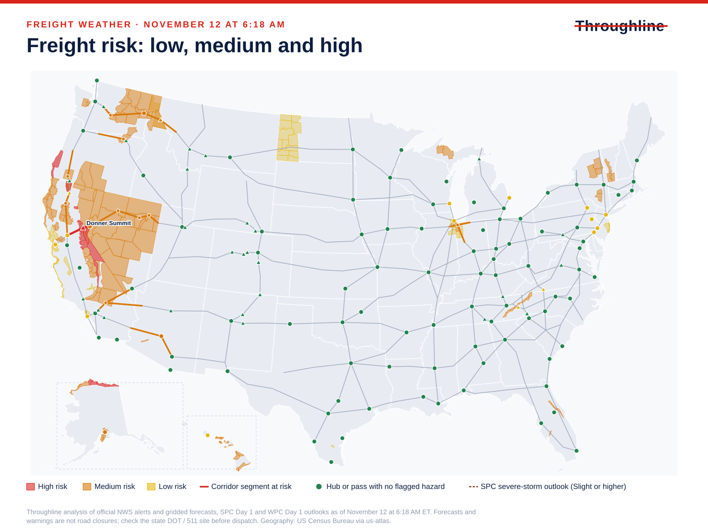
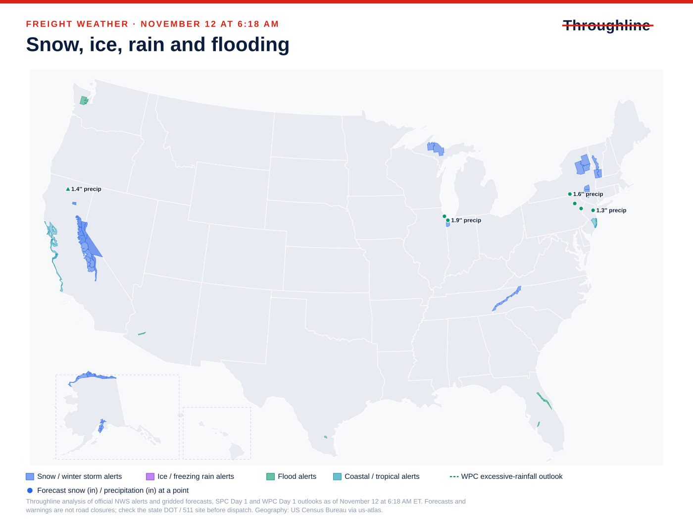
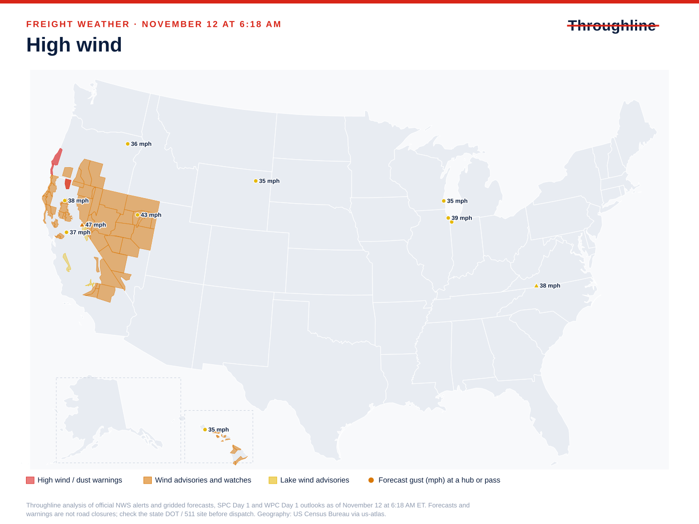
Sources: NWS national active-alert snapshot; SPC Day 1 convective outlook; WPC excessive rainfall outlook; WPC Winter Storm Severity Index
Sierra Nevada I-80: winter storm warning Friday into Saturday (CA)
High risk · CA · I-80. What the official forecasts and warnings say:
Donner Summit, CA: Winter Storm Warning Fri 1:00 PM – Sat 1:00 PM ET (10 AM Friday – 10 AM PST Saturday); gusts to 47 mph forecast at the summit.
NWS Sacramento’s warning covers the northern Sierra above 6,000 feet, including I-80 and US-50: snow accumulations up to a foot, up to 2 feet at the highest peaks, and gusts as high as 60 mph. It says travel could be very difficult and the Friday evening commute could be affected.
Truckee and Lake Tahoe: NWS Reno’s Winter Storm Warning for the same hours forecasts heavy wet snow near 12 inches above 7,000 feet and up to 6 inches below, with gusts of 35–45 mph in Truckee and the Tahoe communities.
Caltrans QuickMap (CA) could not be read at Nov 12, 6:31 AM ET; check it directly before dispatch.
- Where the pickup allows, cross the Sierra before Friday morning; otherwise confirm a receiver contact who can move a Friday-evening or Saturday-morning appointment.
- Ask the carrier how it will handle chain controls if Caltrans posts them. This review could not read a current Caltrans report, so check it directly before dispatch.
- Tarp and secure open-deck freight for heavy wet snow and strong gusts.
Sources: NWS Winter Storm Warning: Lassen Volcanic National Park and more; NWS point forecast: Donner Summit, CA; NWS Winter Storm Warning: Greater Lake Tahoe Area
I-5 from the Sacramento Valley to southern Oregon: high wind Thursday night into Friday (CA/OR)
Medium risk · CA, OR · I-5. What the official forecasts and warnings say:
Weed and the Shasta Valley, CA: High Wind Warning Fri 1:00 AM – Fri 4:00 PM ET. NWS Medford expects south winds 25–40 mph with gusts up to 70 mph on portions of I-5, and says travel will be difficult, especially for high-profile vehicles.
Redding, CA: Wind Advisory Fri 7:00 AM – Fri 10:00 PM ET; gusts up to 45 mph expected, strongest Friday late morning and afternoon. Gusts to 38 mph forecast at the Redding point.
Medford, OR: Wind Advisory Thu 11:00 AM – Fri 1:00 PM ET for Jackson County, including I-5; gusts up to 45 mph, highest from Phoenix to Talent and Ashland.
Road restrictions confirmed on the official state DOT / 511 site at the time shown. A weather warning alone is not listed here.
Caltrans QuickMap (CA) could not be read at Nov 12, 6:31 AM ET; check it directly before dispatch.
- Plan empty and high-profile trailers on I-5 between Redding and Ashland around Thursday night and Friday, and ask the carrier before dispatch whether it will hold for the wind.
- Over Siskiyou Summit the truck needs chains or traction tires aboard under Oregon’s snow-zone rule, even on bare pavement.
- Allow for daytime lane closures on northbound I-5 near the OR 99 interchange (MP 58–67) when setting delivery windows.
| Route and location | Status | Official report |
|---|---|---|
| I-5, MP 1 to 11, Siskiyou Summit snow zone (OR) | Chain control / traction law: Snow-zone rule shown on TripCheck: “Carry chains or traction tires regardless of conditions.” The Siskiyou Summit reporting stations showed bare pavement. | ODOT TripCheck, Southwest Oregon road conditions, Snow-zone entry shows no timestamp; Siskiyou Summit stations last updated 11/11/2026 8:06 PM (time zone not shown); retrieved Nov 12, 6:32 AM ET |
| I-5, Northbound MP 58.18 to 66.7, intersection with Pacific Highway (OR 99) (OR) | Lane closure: Construction: “Expect intermittent lane, ramp and shoulder closures Sunday – Friday from 7 a.m. – 7 p.m.” Estimated delay under 20 minutes. | ODOT TripCheck, Southwest Oregon road conditions, Last Updated 10/21/2026 5:15 PM (time zone not shown); retrieved Nov 12, 6:32 AM ET |
Sources: NWS High Wind Warning: Central Siskiyou County; NWS Wind Advisory: South-Central Shasta County Including Redding Metro; Northern Sacramento Valley in Tehama County and more; NWS point forecast: Redding, CA; NWS Wind Advisory: Jackson County; ODOT TripCheck, Southwest Oregon road conditions: I-5, MP 1 to 11, Siskiyou Summit snow zone; ODOT TripCheck, Southwest Oregon road conditions: I-5, Northbound MP 58.18 to 66.7, intersection with Pacific Highway (OR 99)
Reno and Nevada I-80: Friday wind advisories (NV/CA)
Medium risk · NV, CA · I-80. What the official forecasts and warnings say:
Reno, NV: Wind Advisory Fri 1:00 PM – Sat 1:00 AM ET. NWS Reno expects gusts up to 55 mph, and up to 65 mph in wind-prone areas along US-395/I-580. Gusts to 39 mph forecast at the Reno point.
Winnemucca, NV: Wind Advisory from Fri 1:00 PM ET. The alert’s coded end is Fri 2:00 PM ET, but NWS Elko’s text runs it from 10 AM PST Friday until 3 AM PST Saturday, with gusts near 50 mph, blowing dust and difficult driving for high-profile vehicles.
Sacramento, CA: gusts to 37 mph forecast.
NVRoads (NV) could not be read at Nov 12, 6:30 AM ET; check it directly before dispatch.
Caltrans QuickMap (CA) could not be read at Nov 12, 6:31 AM ET; check it directly before dispatch.
- Tell carriers running empty or lightly loaded vans across Nevada on Friday afternoon and evening about the wind window, and leave room in the delivery appointment for a stop.
- Check securement on open-deck freight before it leaves; blowing dust can also slow the run.
Sources: NWS Wind Advisory: Lassen-Eastern Plumas-Eastern Sierra Counties; Greater Reno-Carson City-Minden Area; NWS point forecast: Reno, NV; NWS Wind Advisory: Humboldt County; Northern Elko County; Southeastern Elko County; Ruby Mountains and East Humboldt Range and more; NWS point forecast: Sacramento, CA
Mojave Desert I-15 and I-40: Friday-night wind (CA)
Medium risk · CA · I-15, I-40. What the official forecasts and warnings say:
Barstow, CA: Wind Advisory Fri 7:00 PM – Sat 1:00 PM ET (4 PM Friday – 10 AM PST Saturday). NWS Las Vegas expects southwest winds 20–30 mph with gusts up to 55 mph across the western Mojave Desert.
Caltrans QuickMap (CA) could not be read at Nov 12, 6:31 AM ET; check it directly before dispatch.
- Ask carriers on I-15 and I-40 out of Barstow whether Friday-night runs with empty or high-profile trailers will wait for the wind to ease, and set Saturday-morning receivers’ expectations now.
Sources: NWS Wind Advisory: Death Valley National Park; Western Mojave Desert
Northwest Indiana: lake-effect snow for the Friday-morning commute (IN)
Medium risk · IN · I-65, I-80, I-90. What the official forecasts and warnings say:
Gary, IN: Winter Weather Advisory Fri 1:00 AM – Fri 11:00 AM ET (midnight – 10 AM CST) for Lake County, IN. NWS Chicago expects accumulating wet snow away from the lakeshore, localized totals of 3 inches or more, and slippery roads, especially on bridges and overpasses.
Gary, IN: 1.9 in of precipitation forecast in the next 36 h; gusts to 38 mph forecast.
Porter County, IN and Cook and Will counties, IL: an NWS Chicago special weather statement says lake-effect rain turns to snow tonight, with possible slushy accumulations and sudden sharp visibility drops into Friday morning.
Indiana 511 (IN) could not be read at Nov 12, 6:31 AM ET; check it directly before dispatch.
- For Friday-morning deliveries through Lake and Porter counties into Chicago-area docks, confirm whether the receiver will take a later appointment and give the carrier a time buffer.
- Indiana 511 could not be read this morning; ask the carrier to check it before the run.
Sources: NWS Winter Weather Advisory: Lake; NWS point forecast: Gary, IN; NWS Special Weather Statement: Kankakee; Cook; Eastern Will; Porter; Newton; Jasper
Gila River flooding from a dam release, Maricopa and Yuma counties (AZ)
Medium risk · AZ · I-10. What the official forecasts and warnings say:
Phoenix, AZ: Flood Warning until Tue 1:00 PM ET (11 AM MST Tuesday) for Maricopa and northeastern Yuma counties.
NWS Phoenix says releases from Painted Rock Dam will increase over the next couple of days, peaking at 3,000 cfs, flooding farmlands and low-water crossings along the Gila River that may not be passable.
AZ511 (AZ) could not be read at Nov 12, 6:28 AM ET; check it directly before dispatch.
- If a pickup or delivery sits near the Gila River in western Maricopa or northeastern Yuma County, ask the facility whether its approach crosses a low-water crossing and whether it is passable.
- This is a river-flood warning, not an I-10 closure; no Arizona highway closure from it was confirmed this morning.
Floods, coastal flooding and federal disaster declarations
Florida river flooding continues. NWS Melbourne reports Major flooding on the St. Johns River at the gauge west of Cocoa in Brevard County, forecast to keep rising within Major flood stage through this weekend; near Sanford and DeLand the river is just below Minor flood stage and forecast to reach it. NWS Tampa Bay has minor flooding on the Peace River at Arcadia at SR 70 until Friday afternoon. These are river levels, not road closures: confirm low-lying facility approaches in those counties.
In the West, besides the Gila River warning in Arizona (hot spot above), NWS Seattle has a Flood Watch for Mason County, Washington from late tonight through late Saturday night, forecasting three to four and a half inches of rain in parts of the area. NWS San Francisco’s coastal flood advisory for the San Francisco Bay shoreline and North Bay interior valleys runs until 4 p.m. PST Friday, with up to 1.5 feet of inundation possible in low-lying areas; NWS says isolated road closures are possible, which is a forecast, not a reported closure. A Coastal Flood Watch covers San Luis Obispo and Santa Barbara central coast beaches on Saturday.
OpenFEMA lists five declarations in the last 30 days: a major disaster for Hurricane Isaias in 15 Florida Panhandle counties (declared October 27), an emergency for severe storms and flooding in New Mexico (October 26), a fire management declaration for the Norte Fire in California (October 16), and emergencies for Typhoon Champi in Guam and Tropical Storm Champi in the Northern Mariana Islands (October 17). NHC’s only active system is Tropical Depression Pena in the central Pacific near 9.8°N, 172°W, moving west at 16 mph.
Sources: NWS Flood Warning: St. Johns River near Cocoa (Brevard, FL); NWS Flood Warning: St. Johns River near Sanford (Seminole, FL); NWS Flood Warning: St. Johns River near DeLand (Lake and Volusia, FL); NWS Flood Warning: Peace River at Arcadia at SR 70 (DeSoto, FL); NWS Flood Watch: Mason County, WA; NWS Coastal Flood Advisory: North Bay Interior Valleys; San Francisco Bay Shoreline; NWS Coastal Flood Watch: San Luis Obispo and Santa Barbara Central Coast beaches; FEMA DR-4955-FL: Hurricane Isaias (major disaster); FEMA EM-3660-NM: Severe storms and flooding (emergency); FEMA FM-5679-CA: Norte Fire (fire management); FEMA EM-3658-MP: Tropical Storm Champi (emergency); FEMA EM-3659-GU: Typhoon Champi (emergency); NHC: Tropical Depression Pena (central Pacific)
Diesel: EIA’s November 9 weekly average
EIA’s weekly retail price table, released November 10, puts U.S. on-highway diesel (all types, including taxes) at $6.127 per gallon for the week of November 9, down $0.165 from $6.292 on November 2. EIA lists November 17 as the next release. This run’s automated EIA feed did not load, so the figures were read from EIA’s page.
A national weekly average is a budgeting reference, not the fuel cost of a particular FTL, partial or expedited move. Ask which fuel week and surcharge basis a quote uses before comparing totals.
| Measure | EIA value |
|---|---|
| U.S. on-highway diesel, week of November 9 | $6.127 per gallon, taxes included |
| Previous week, November 2 | $6.292 per gallon |
| Weekly change | Down $0.165 per gallon |
| Release / next scheduled release | November 10 / November 17, 2026 |
Sources: EIA U.S. gasoline and diesel retail prices (weekly)
Coverage and limits of this morning’s review
Official feeds loaded at 6:18 a.m. ET: NWS active alerts (62 alerts), NWS gridded point forecasts (272 of 272 grid cells), the NWS watches, warnings and advisories map service, SPC’s Day 1 convective outlook, WPC’s Day 1 excessive rainfall outlook (no risk area today) and Winter Storm Severity Index, NHC active tropical cyclones and OpenFEMA disaster declarations. The automated EIA diesel feed did not load; the diesel figures come from EIA’s own page. SPC and WPC text discussions did not return current copies this morning, so this briefing uses their map products only.
State DOT / 511 checks, about 6:28–6:33 a.m. ET: Oregon’s TripCheck loaded and listed the I-5 items shown in the I-5 hot spot. AZ511’s alert list loaded and showed one closure, SR 89A in both directions between about mileposts 387 and 390 (Pine Flats Campground to the Oak Creek Vista overlook) for repairs to flood-damaged highway, last updated Nov 11, 5:54 PM; that is not on the Phoenix-area corridors in this briefing, and AZ511’s full traffic-event list returned only an app shell. NVRoads (Nevada) and Indiana 511 returned app shells with no data. Caltrans’ highway-information pages returned reports dated between August 21 and November 8 rather than current ones, so California is marked unavailable. Check those sites directly before dispatch.
This review is selective. It cannot certify every road, crash, construction zone or closure, and conditions change after a snapshot. Forecasts, warnings and outlooks are not closures; only restrictions an official DOT / 511 page listed appear as restrictions.
Sources: NWS national active-alert snapshot; SPC Day 1 convective outlook; WPC excessive rainfall outlook; WPC Winter Storm Severity Index; EIA U.S. gasoline and diesel retail prices (weekly); AZ511 alerts list
Sources and editorial notes
Original analysis by Throughline Systems. Source links may show newer releases after this article’s publication; the observation and issue dates below identify the material used. Agency citations do not imply endorsement.
- NWS national active-alert snapshot
National snapshot retrieved November 12 at 6:18 AM ET; each alert has its own issue and valid times
Accessed .
- SPC Day 1 convective outlook
Retrieved November 12 at 6:18 AM ET; highest category nationally: MRGL
Accessed .
- WPC excessive rainfall outlook
Day 1 outlook retrieved November 12 at 6:18 AM ET; highest category: none
Accessed .
- WPC Winter Storm Severity Index
Day 1 retrieved November 12 at 6:18 AM ET; highest impact: MODERATE
Accessed .
- NWS Winter Storm Warning: Lassen Volcanic National Park and more
Issued 2026-11-12T00:05:00-08:00; valid until 2026-11-14T10:00:00-08:00
Accessed .
- NWS point forecast: Donner Summit, CA
Gridded forecast retrieved November 12 at 6:18 AM ET, next 36 hours
Accessed .
- NWS Flood Warning: Maricopa, AZ; Yuma, AZ
Issued 2026-11-11T11:41:00-07:00; valid until 2026-11-17T11:00:00-07:00
Accessed .
- NWS Wind Advisory: Lassen-Eastern Plumas-Eastern Sierra Counties; Greater Reno-Carson City-Minden Area
Issued 2026-11-11T11:52:00-08:00; valid until 2026-11-13T22:00:00-08:00
Accessed .
- NWS point forecast: Reno, NV
Gridded forecast retrieved November 12 at 6:18 AM ET, next 36 hours
Accessed .
- NWS Wind Advisory: Humboldt County; Northern Elko County; Southeastern Elko County; Ruby Mountains and East Humboldt Range and more
Issued 2026-11-11T08:15:00-08:00; valid until 2026-11-13T11:00:00-08:00
Accessed .
- NWS point forecast: Sacramento, CA
Gridded forecast retrieved November 12 at 6:18 AM ET, next 36 hours
Accessed .
- NWS Dense Fog Advisory: Northern Panhandle; Coeur d'Alene Area; Central Panhandle Mountains; Moses Lake Area; Upper Columbia Basin and more
Issued 2026-11-11T21:46:00-08:00; valid until 2026-11-12T07:00:00-08:00
Accessed .
- NWS Winter Weather Advisory: Lake
Issued 2026-11-12T04:14:00-06:00; valid until 2026-11-13T10:00:00-06:00
Accessed .
- NWS point forecast: Gary, IN
Gridded forecast retrieved November 12 at 6:18 AM ET, next 36 hours
Accessed .
- NWS Winter Weather Advisory: Anchorage
Issued 2026-11-11T23:02:00-09:00; valid until 2026-11-12T05:00:00-09:00
Accessed .
- NWS Wind Advisory: Death Valley National Park; Western Mojave Desert
Issued 2026-11-12T00:05:00-08:00; valid until 2026-11-14T10:00:00-08:00
Accessed .
- NWS Wind Advisory: South-Central Shasta County Including Redding Metro; Northern Sacramento Valley in Tehama County and more
Issued 2026-11-12T01:01:00-08:00; valid until 2026-11-13T19:00:00-08:00
Accessed .
- NWS point forecast: Redding, CA
Gridded forecast retrieved November 12 at 6:18 AM ET, next 36 hours
Accessed .
- NWS Wind Advisory: Jackson County
Issued 2026-11-12T00:03:00-08:00; valid until 2026-11-13T10:00:00-08:00
Accessed .
- NWS Winter Storm Warning: Greater Lake Tahoe Area
Issued 2026-11-12T00:33:00-08:00; valid 2026-11-13T10:00:00-08:00 through 2026-11-14T10:00:00-08:00
Accessed .
- NWS High Wind Warning: Central Siskiyou County
Issued 2026-11-12T00:03:00-08:00; listed valid 2026-11-12T22:00:00-08:00 through 2026-11-13T13:00:00-08:00
Accessed .
- NWS Special Weather Statement: Kankakee; Cook; Eastern Will; Porter; Newton; Jasper
Issued 2026-11-12T04:31:00-06:00; describes tonight through Friday morning
Accessed .
- NWS Winter Storm Watch: Yosemite, Kings Canyon and Sequoia areas above 6,000 feet
Issued 2026-11-12T02:33:00-08:00; valid 2026-11-13T16:00:00-08:00 through 2026-11-17T04:00:00-08:00
Accessed .
- NWS Winter Weather Advisory: Baraga; Marquette
Issued 2026-11-12T01:32:00-05:00; valid until 2026-11-13T12:00:00-05:00
Accessed .
- NWS Winter Weather Advisory: Western Essex; Eastern Addison; Eastern Rutland
Issued 2026-11-12T01:20:00-05:00; valid 2026-11-12T10:00:00-05:00 through 2026-11-13T10:00:00-05:00
Accessed .
- NWS Winter Weather Advisory: Hamilton; Northern Warren; Bennington; Western Windham
Issued 2026-11-12T00:02:00-05:00; valid 2026-11-12T10:00:00-05:00 through 2026-11-13T10:00:00-05:00
Accessed .
- NWS Winter Weather Advisory: Tennessee Smoky Mountains above 3,000 feet
Issued 2026-11-11T23:09:00-05:00; valid 2026-11-12T19:00:00-05:00 through 2026-11-14T07:00:00-05:00
Accessed .
- NWS Coastal Flood Advisory: Ocean; Coastal Ocean (NJ)
Issued 2026-11-12T02:30:00-05:00; valid 2026-11-12T08:00:00-05:00 through 2026-11-12T14:00:00-05:00
Accessed .
- NWS Flood Warning: St. Johns River near Cocoa (Brevard, FL)
Issued 2026-11-11T20:41:00-05:00; product valid until 2026-11-12T12:00:00-05:00, to be updated
Accessed .
- NWS Flood Warning: St. Johns River near Sanford (Seminole, FL)
Issued 2026-11-11T20:46:00-05:00; product valid until 2026-11-12T12:15:00-05:00, to be updated
Accessed .
- NWS Flood Warning: St. Johns River near DeLand (Lake and Volusia, FL)
Issued 2026-11-11T20:37:00-05:00; valid until 2026-11-15T07:00:00-05:00
Accessed .
- NWS Flood Warning: Peace River at Arcadia at SR 70 (DeSoto, FL)
Issued 2026-11-11T20:05:00-05:00; valid until 2026-11-13T17:00:00-05:00
Accessed .
- NWS Flood Watch: Mason County, WA
Issued 2026-11-12T02:12:00-08:00; valid 2026-11-13T04:00:00-08:00 through 2026-11-15T04:00:00-08:00
Accessed .
- NWS Coastal Flood Advisory: North Bay Interior Valleys; San Francisco Bay Shoreline
Issued 2026-11-11T22:48:00-08:00; valid until 2026-11-13T16:00:00-08:00
Accessed .
- NWS Coastal Flood Watch: San Luis Obispo and Santa Barbara Central Coast beaches
Issued 2026-11-11T18:06:00-08:00; valid 2026-11-14T03:00:00-08:00 through 2026-11-14T15:00:00-08:00
Accessed .
- NHC: Tropical Depression Pena (central Pacific)
NHC active-storm data last updated 2026-11-12 09:00 UTC
Accessed .
- FEMA DR-4955-FL: Hurricane Isaias (major disaster)
Declared 2026-10-27 (OpenFEMA declarations, last 30 days)
Accessed .
- FEMA EM-3660-NM: Severe storms and flooding (emergency)
Declared 2026-10-26 (OpenFEMA declarations, last 30 days)
Accessed .
- FEMA FM-5679-CA: Norte Fire (fire management)
Declared 2026-10-16 (OpenFEMA declarations, last 30 days)
Accessed .
- FEMA EM-3658-MP: Tropical Storm Champi (emergency)
Declared 2026-10-17 (OpenFEMA declarations, last 30 days)
Accessed .
- FEMA EM-3659-GU: Typhoon Champi (emergency)
Declared 2026-10-17 (OpenFEMA declarations, last 30 days)
Accessed .
- EIA U.S. gasoline and diesel retail prices (weekly)
Release date 11/10/2026; week of 11/09/26 vs 11/02/26; next release 11/17/2026; dollars per gallon including taxes
Accessed .
- AZ511 alerts list
SR 89A alert last updated Nov 11 2026, 5:54 PM (time zone not shown)
Accessed .
- ODOT TripCheck, Southwest Oregon road conditions: I-5, MP 1 to 11, Siskiyou Summit snow zone
Chain control / traction law as reported Snow-zone entry shows no timestamp; Siskiyou Summit stations last updated 11/11/2026 8:06 PM (time zone not shown)
Accessed .
- ODOT TripCheck, Southwest Oregon road conditions: I-5, Northbound MP 58.18 to 66.7, intersection with Pacific Highway (OR 99)
Lane closure as reported Last Updated 10/21/2026 5:15 PM (time zone not shown)
Accessed .