November 13 briefing: Sierra I-80 winter storm, western wind, Indiana lake-effect snow
November 13 shipper briefing: Sierra I-80 snow, wind on I-5, Nevada I-80, I-84 and the Mojave, Indiana lake-effect snow, Gila River flooding, diesel $6.127.
By Throughline Systems · · 8 min read · Updated
What matters for your next load
- Cross Donner Summit before the snow where the pickup allows, or confirm a receiver contact who can move the appointment: Sierra winter storm warnings run 10 AM Friday to 10 AM PST Saturday, with the heaviest snow late Friday morning into the night.
- Plan empty and high-profile trailers around Friday’s western wind: I-5 in the Sacramento and Shasta valleys (gusts up to 70 mph near Weed until 1 PM PST), Reno and Nevada I-80, I-84 east of Pendleton, and I-15/I-40 near Barstow Friday night.
- In Oregon, TripCheck says to carry chains or traction tires in the I-5 Siskiyou Summit and I-84 Blue Mountains snow zones; these informational carry rules are not orders to install chains. Construction lane closures are also listed near Grants Pass and Pendleton.
- EIA’s latest weekly diesel average is $6.127 per gallon for November 9, down $0.165; confirm which fuel week a quote uses.
The national picture: the Pacific storm reaches the Sierra and spreads wind across the West
Research snapshots: the initial forecast review was November 13, 2026 at 6:16 a.m. ET, followed by an independent national alert, outlook and selected DOT review at 7:05 a.m. ET. The regional examples below highlight shipment-planning questions; they do not rank every route or establish a nationwide delay forecast. The maps preserve official forecast and warning-zone geography, with separate coverage limits and valid periods.
California, Nevada and Oregon have several significant forecast hazards in the sources checked. NWS Sacramento and NWS Reno have winter storm warnings for the northern Sierra and the Lake Tahoe area from 10 a.m. Friday to 10 a.m. PST Saturday; NWS Reno’s Mono County warning covers the same hours with gusts of 55 to 70 mph along US-395, and NWS Hanford’s warning for the southern Sierra above 6,000 feet runs from 10 a.m. today to 4 a.m. PST Tuesday, with up to 20 inches of snow. WPC’s Day 1 Winter Storm Severity Index reaches Major and Extreme in parts of northern California’s mountains. Wind warnings and advisories run from the Oregon and northern California coast through the Sacramento and Shasta valleys, Reno and northern Nevada to the Mojave Desert, and NWS Pendleton has wind advisories along I-84 at the base of the Blue Mountains and in the Grande Ronde Valley. SPC’s Day 1 outlook shows general thunderstorms only, with no severe risk area, and WPC’s Day 1 excessive rainfall outlook has no risk area.
East of the Rockies most of the winter weather ends by early afternoon: lake-effect snow advisories for Lake County, Indiana and the south Chicago suburbs until noon CST, and for Marquette and Baraga counties and the Grand Traverse area in Michigan; a Winter Storm Warning for Otsego County, New York until 1 p.m. EST, where NWS Binghamton reports 6 to 12 inches already on the ground above 1,500 feet, with advisories in the Catskills, Adirondacks, southern Vermont and north-central Pennsylvania. NWS Morristown’s Winter Weather Advisory for Tennessee’s southern Appalachians above 3,000 feet runs from 10 a.m. today to 1 p.m. EST Saturday and names higher roads such as I-26 at Sam’s Gap and US-441 at Newfound Gap, not I-40. Freeze warnings stretch from Oklahoma and Arkansas to North Carolina and Virginia, and dense fog advisories cover parts of the northern and central Plains this morning.
Sources: NWS national active-alert snapshot; SPC Day 1 convective outlook; WPC excessive rainfall outlook; WPC Winter Storm Severity Index; NWS Winter Storm Warning: Lassen Volcanic National Park and more; NWS Winter Storm Warning: Greater Lake Tahoe Area; NWS Winter Storm Warning: Mono County, CA; NWS Winter Storm Warning: southern Sierra Nevada above 6,000 feet; NWS High Wind Warning: Central Siskiyou County; NWS Winter Weather Advisory: Southern Cook; Eastern Will; Lake; NWS Winter Storm Warning: Otsego County, NY; NWS Winter Weather Advisory: Tennessee southern Appalachians above 3,000 feet
The three freight weather maps
The national overview maps the SPC Day 1 thunderstorm outlook; separate close-ups show selected northern Sierra winter-storm and California–Oregon high-wind warning zones. Sources were reviewed at 7:05 AM ET on November 13. Each image states its issue or retrieval time, valid period and coverage limits. Shading is a forecast or warning zone, not a confirmed road closure; unshaded areas are not an all-clear. Alaska and Hawaii insets on the overview show geography only.
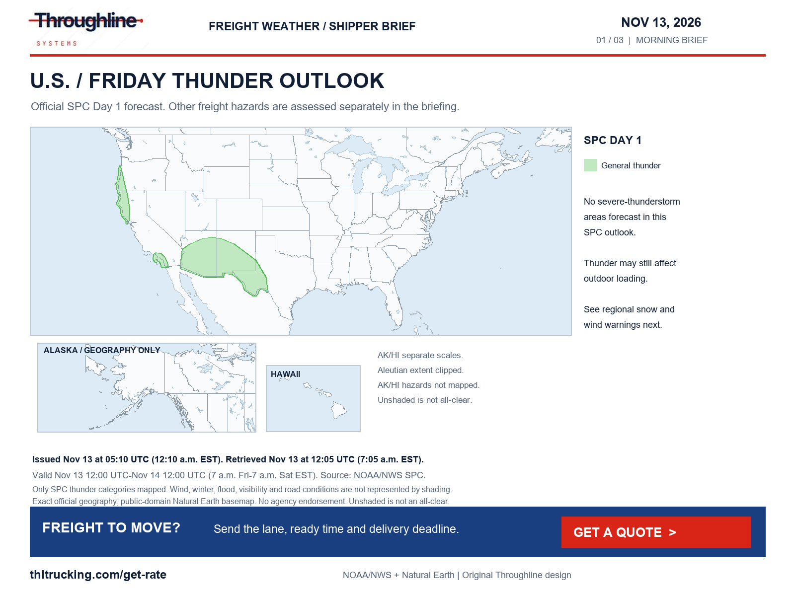
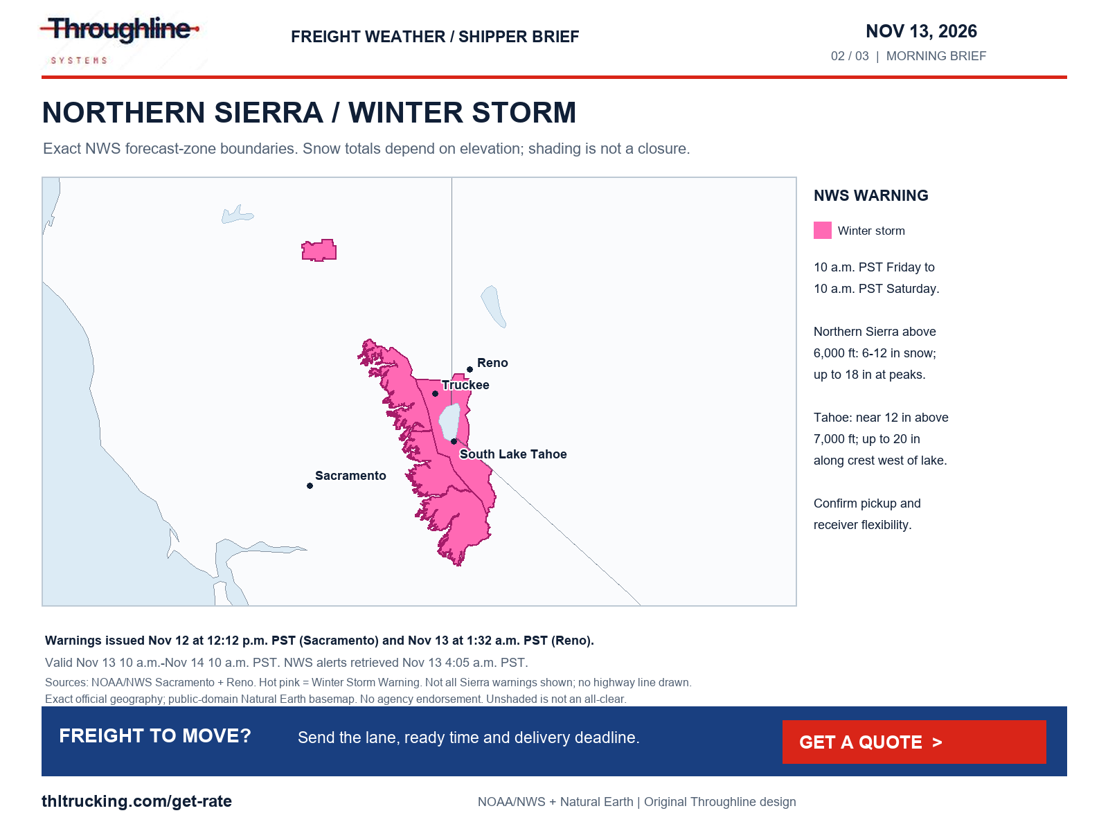
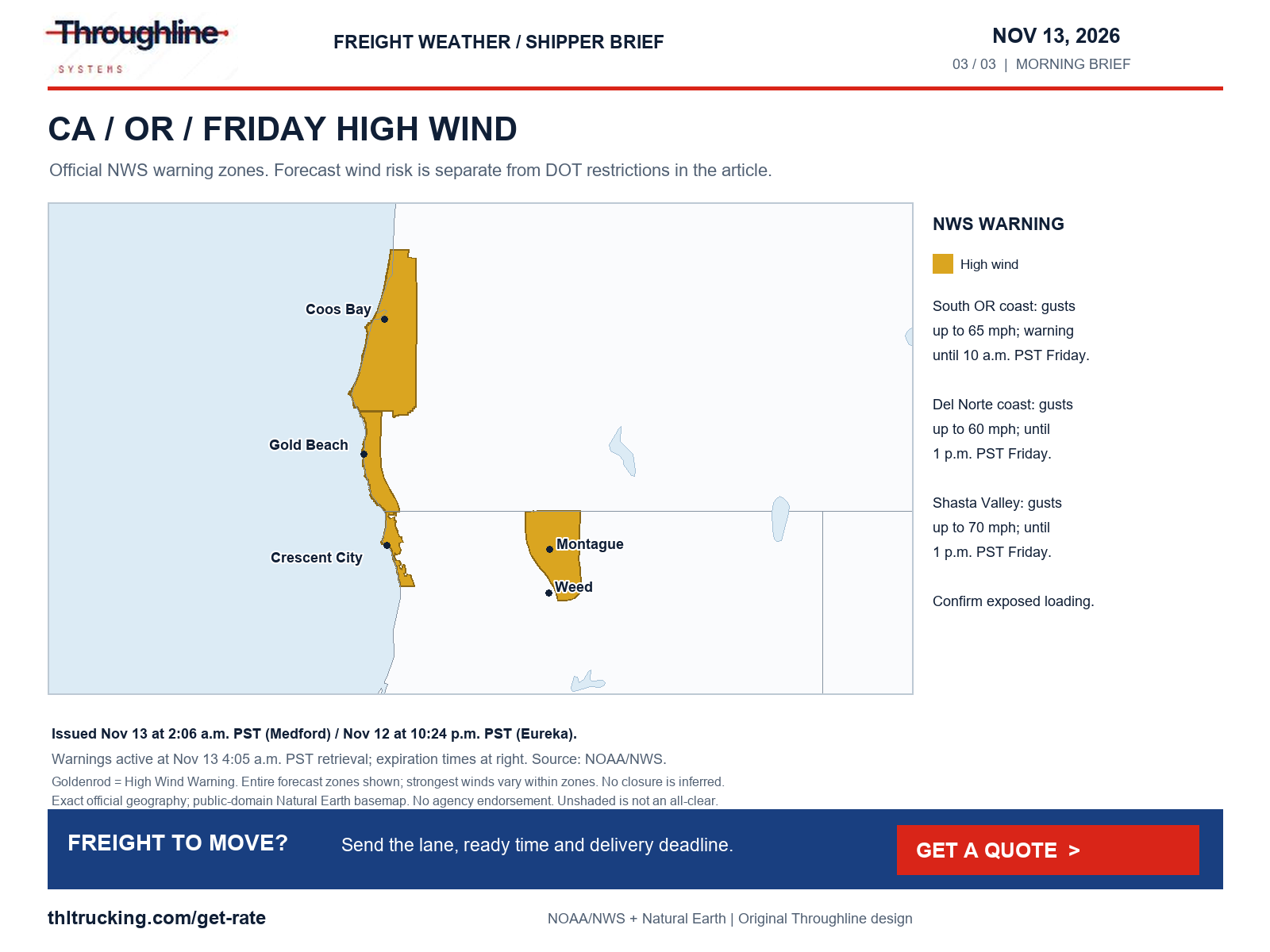
Sources: NWS national active-alert snapshot; SPC Day 1 convective outlook; WPC excessive rainfall outlook; WPC Winter Storm Severity Index
Sierra Nevada I-80: winter storm warning Friday into Saturday (CA)
High risk · CA · I-80. What the official forecasts and warnings say:
Donner Summit, CA: Winter Storm Warning Fri 1:00 PM – Sat 1:00 PM ET (10 AM Friday – 10 AM PST Saturday); 6.1 in of snow forecast in the next 36 h; gusts to 47 mph forecast.
NWS Sacramento’s warning covers the northern Sierra above 6,000 feet, including I-80 and US-50: 6 to 12 inches of snow, up to 18 inches at the highest peaks, and gusts as high as 60 mph. It says the conditions will impact the Friday evening commute, with the heaviest snow late Friday morning into the overnight hours and snow levels dropping to 5,500–6,000 feet Saturday morning.
Truckee and Lake Tahoe: NWS Reno’s warning for the same hours forecasts heavy wet snow near 12 inches above 7,000 feet and up to 6 inches below, up to 20 inches along the crest west of Lake Tahoe, gusts of 45–55 mph in Truckee and the Tahoe communities, and a burst of heavy snow late this afternoon into the evening.
Road restrictions confirmed on the official state DOT / 511 site at the time shown. A weather warning alone is not listed here.
- Where the pickup allows, cross the Sierra before late morning Pacific time; otherwise confirm a receiver contact who can move a Friday-evening or Saturday-morning appointment.
- Ask the carrier how it will handle chain controls if Caltrans posts them. The 4:05 AM PST Caltrans report requires westbound trucks to stop for a brake check 0.5 mile west of Nyack; check QuickMap again before dispatch.
- Tarp and secure open-deck freight for heavy wet snow and strong gusts.
| Route and location | Status | Official report |
|---|---|---|
| I-80 westbound, 0.5 mile west of Nyack, Placer County (CA) | Restricted (e.g. high-profile or light vehicles): All westbound trucks are required to stop for a brake check. This entry is a truck inspection requirement, not a weather closure. | Caltrans highway conditions, November 13, 2026, 4:05 AM PST; retrieved Nov 13, 7:05 AM ET |
Sources: NWS Winter Storm Warning: Lassen Volcanic National Park and more; NWS point forecast: Donner Summit, CA; NWS Winter Storm Warning: Greater Lake Tahoe Area; Caltrans highway conditions: I-80 westbound, 0.5 mile west of Nyack, Placer County
Sacramento Valley I-5 and Nevada I-80: Friday wind, plus high-tide flooding in the Delta and Bay (CA/NV)
Medium risk · CA, NV · I-5, I-80. What the official forecasts and warnings say:
Sacramento, CA: Wind Advisory Fri 7:00 AM – Fri 10:00 PM ET (4 AM – 7 PM PST); NWS Sacramento expects gusts of 35–40 mph in the central and southern Sacramento Valley, strongest Friday afternoon. Gusts to 37 mph forecast at the Sacramento point.
Redding, CA: Wind Advisory Fri 7:00 AM – Fri 10:00 PM ET; gusts up to 45 mph in the northern Sacramento Valley, strongest late morning and afternoon. Gusts to 38 mph forecast at the Redding point.
Reno, NV: Wind Advisory Fri 1:00 PM – Sat 1:00 AM ET (10 AM – 10 PM PST); gusts up to 55 mph, and up to 65 mph in wind-prone areas along US-395/I-580. Gusts to 35 mph forecast at the Reno point.
Northern Nevada I-80 (Winnemucca, Elko, Wells): NWS Elko Wind Advisory Fri 1:00 PM – Sat 6:00 AM ET, with gusts near 50 mph, blowing dust at times and difficult driving for high-profile vehicles.
Sacramento and Oakland: the Sacramento Flood Advisory (until Fri 7:00 PM ET) is for abnormally high tides along the Sacramento and San Joaquin rivers and other Delta waterways; the Oakland Coastal Flood Advisory (until Fri 7:00 PM ET) allows up to 1.5 ft of inundation in low-lying areas near the Bay shoreline. Gusts to 35 mph forecast at the Oakland point.
Road restrictions confirmed on the official state DOT / 511 site at the time shown. A weather warning alone is not listed here.
NVRoads (NV) could not be read at Nov 13, 6:24 AM ET; check it directly before dispatch.
- Plan empty and high-profile trailers on I-5 between Sacramento and Redding and on I-80 from Reno across Nevada around today’s wind, and ask the carrier before dispatch whether it will hold.
- For Bay Area and Delta pickups and deliveries in low-lying areas, ask the facility whether the midday high tide affects its approach.
- NVRoads listed no advisories, but its event list did not load. Caltrans lists overnight southbound I-5 construction closure between County Road 102 and Old River Road through November 13, 10 PM–6 AM PST; confirm reopening before using that segment.
| Route and location | Status | Official report |
|---|---|---|
| I-5 southbound, County Road 102 north of Woodland to Old River Road, Yolo County (CA) | Closed: Construction closure listed 10 PM to 6 AM each night/morning through November 13. It was within the listed work window at the 4:05 AM PST report; confirm reopening before dispatch. | Caltrans highway conditions, November 13, 2026, 4:05 AM PST; retrieved Nov 13, 7:05 AM ET |
Sources: NWS Wind Advisory: Central Colusa County Including Interstate 5; Eastern Colusa County; Sutter and Yuba Counties Below 1000 ft and more; NWS Flood Advisory: Sacramento, CA; San Joaquin, CA; Solano, CA; Yolo, CA; NWS point forecast: Sacramento, CA; NWS Wind Advisory: Lassen-Eastern Plumas-Eastern Sierra Counties; Greater Reno-Carson City-Minden Area; NWS point forecast: Reno, NV; NWS Wind Advisory: South-Central Shasta County Including Redding Metro; Northern Sacramento Valley in Tehama County and more; NWS point forecast: Redding, CA; NWS Coastal Flood Advisory: North Bay Interior Valleys; San Francisco Bay Shoreline; NWS point forecast: Oakland, CA; NWS Wind Advisory: Humboldt County; Northern Elko County and more (NV); Caltrans highway conditions: I-5 southbound, County Road 102 north of Woodland to Old River Road, Yolo County
I-5 from the Shasta Valley to southern Oregon: high wind this morning, Oregon chain rules and lane closures (CA/OR)
Medium risk · CA, OR · I-5. What the official forecasts and warnings say:
Medford, OR: Wind Advisory until Fri 1:00 PM ET (10 AM PST) for Jackson County, including along I-5; NWS Medford expects gusts up to 55 mph, highest from Phoenix to Talent and Ashland.
Weed and the Shasta Valley, CA: High Wind Warning until Fri 4:00 PM ET (1 PM PST); NWS Medford expects south winds 25–40 mph with gusts up to 70 mph on portions of I-5, and says travel will be difficult, especially for high-profile vehicles.
Road restrictions confirmed on the official state DOT / 511 site at the time shown. A weather warning alone is not listed here.
- Confirm the carrier’s operating or holding plan for empty and high-profile trailers between Redding and Ashland using current wind conditions and official restrictions. A forecast warning expiration is not an all-clear to release a truck.
- Over Siskiyou Summit and the passes north of Grants Pass the truck needs chains or traction tires aboard under Oregon’s snow-zone rule, even on bare pavement.
- Allow for daytime lane closures on northbound I-5 near the OR 99 interchange (MP 58–67) when setting delivery windows.
| Route and location | Status | Official report |
|---|---|---|
| I-5, MP 1 to 11, Siskiyou Summit snow zone (OR) | Chain control / traction law: Snow-zone rule shown on TripCheck: “Carry chains or traction tires regardless of conditions.” The Siskiyou Summit reporting stations showed bare pavement. This is an informational carry rule, not an installed-chain order. | ODOT TripCheck, statewide road conditions, Snow-zone entry shows no timestamp; Siskiyou Summit stations last updated 11/12/2026 8:04 PM and 8:05 PM (time zone not shown); retrieved Nov 13, 6:21 AM ET |
| I-5, Northbound MP 58.18 to 66.7, intersection with Pacific Highway (OR 99), Grants Pass area (OR) | Lane closure: Construction: “Expect intermittent lane,ramp and shoulder closures Sunday – Friday from 7 a.m. – 7 p.m.” Estimated delay under 20 minutes. | ODOT TripCheck, statewide road conditions, Last Updated 10/21/2026 5:15 PM (time zone not shown); retrieved Nov 13, 6:21 AM ET |
| I-5, MP 66 to 81, Smith Hill, Stage Road Pass and Sexton Mountain Pass snow zone (Grants Pass to Glendale) (OR) | Chain control / traction law: TripCheck lists this snow zone as requiring drivers to carry chains or traction tires regardless of conditions; the Sexton Pass to Stage Pass stations showed bare pavement. This is an informational carry rule, not an installed-chain order. | ODOT TripCheck, statewide road conditions, Snow-zone entry shows no timestamp; Sexton Pass to Stage Pass stations last updated 11/12/2026 8:03 PM (time zone not shown); retrieved Nov 13, 6:21 AM ET |
Sources: NWS Wind Advisory: Jackson County; NWS High Wind Warning: Central Siskiyou County; ODOT TripCheck, statewide road conditions: I-5, MP 1 to 11, Siskiyou Summit snow zone; ODOT TripCheck, statewide road conditions: I-5, Northbound MP 58.18 to 66.7, intersection with Pacific Highway (OR 99), Grants Pass area; ODOT TripCheck, statewide road conditions: I-5, MP 66 to 81, Smith Hill, Stage Road Pass and Sexton Mountain Pass snow zone (Grants Pass to Glendale)
I-84 over the Blue Mountains: morning fog, then wind through the evening (OR)
Medium risk · OR · I-84. What the official forecasts and warnings say:
Pendleton, OR: Dense Fog Advisory until Fri 12:00 PM ET (9 AM PST), with dense fog observed on I-84 near Pendleton and Cabbage Hill and visibility as low as a quarter mile; Wind Advisory Fri 11:00 AM – Fri 10:00 PM ET (8 AM – 7 PM PST), with southeast gusts up to 50 mph at the base of the Blue Mountains. A Special Weather Statement runs until Fri 10:15 AM ET.
La Grande, OR: Wind Advisory Fri 11:00 AM – Fri 10:00 PM ET for the Grande Ronde Valley, gusts up to 50 mph; gusts to 43 mph forecast at the La Grande point.
Deadman Pass (Cabbage Hill), OR: gusts to 39 mph forecast.
Road restrictions confirmed on the official state DOT / 511 site at the time shown. A weather warning alone is not listed here.
- Plan empty and high-profile trailers on I-84 between Pendleton and La Grande around the 8 AM–7 PM PST wind; TripCheck also lists high-wind warnings for high-profile vehicles from its I-84 sensors east of Pendleton (MP 216–228), the latest updated 11/13/2026 12:43 AM.
- Give early-morning runs a time buffer for fog near Pendleton and Cabbage Hill; over the Blue Mountains (MP 216–261) the truck needs chains or traction tires aboard under Oregon’s snow-zone rule.
- Allow for shoulder and single-lane closures in the Pendleton work zone (MP 207–211).
| Route and location | Status | Official report |
|---|---|---|
| I-84, MP 216 to 261, Cabbage Hill/Deadman Pass to Blue Mountain Summit snow zone (Pendleton to La Grande) (OR) | Chain control / traction law: TripCheck lists this snow zone as requiring drivers to carry chains or traction tires regardless of conditions. The Cabbage Hill and Meacham stations showed no report; the Perry station showed bare pavement. This is an informational carry rule, not an installed-chain order. | ODOT TripCheck, statewide road conditions, Snow-zone entry shows no timestamp; Cabbage Hill stations last updated 11/12/2026 8:10 PM, Meacham 8:42 PM, Perry 8:05 PM (time zone not shown); retrieved Nov 13, 6:21 AM ET |
| I-84, MP 207 to 211, Rieth Road to the Southgate/US 395 interchange, Pendleton (OR) | Lane closure: Construction: shoulder and single-lane closures in both directions with a reduced speed in the work zone; estimated delay under 20 minutes. | ODOT TripCheck, statewide road conditions, Last Updated 11/07/2026 2:28 PM (time zone not shown); retrieved Nov 13, 6:21 AM ET |
Sources: NWS Wind Advisory: Foothills of the Northern Blue Mountains of Oregon; Foothills of the Blue Mountains of Washington; NWS Dense Fog Advisory: Foothills of the Northern Blue Mountains of Oregon; Foothills of the Blue Mountains of Washington; NWS Special Weather Statement: Foothills of the Northern Blue Mountains of Oregon; Foothills of the Blue Mountains of Washington; NWS Wind Advisory: Grande Ronde Valley; Wallowa County; NWS point forecast: La Grande, OR; NWS point forecast: Deadman Pass (Cabbage Hill), OR; ODOT TripCheck, statewide road conditions: I-84, MP 216 to 261, Cabbage Hill/Deadman Pass to Blue Mountain Summit snow zone (Pendleton to La Grande); ODOT TripCheck, statewide road conditions: I-84, MP 207 to 211, Rieth Road to the Southgate/US 395 interchange, Pendleton
Mojave Desert I-15 and I-40: wind Friday night into Saturday morning (CA/NV)
Medium risk · CA, NV · I-15, I-40. What the official forecasts and warnings say:
Barstow, CA: Wind Advisory Fri 7:00 PM – Sat 1:00 PM ET (4 PM Friday – 10 AM PST Saturday); NWS Las Vegas expects south winds 20–30 mph with gusts up to 50 mph across the western Mojave Desert. Gusts to 37 mph forecast at the Barstow point.
Las Vegas, NV: gusts to 36 mph forecast.
NVRoads (NV) could not be read at Nov 13, 6:24 AM ET; check it directly before dispatch.
- Ask carriers on I-15 and I-40 out of Barstow whether Friday-night runs with empty or high-profile trailers will wait for the wind to ease, and set Saturday-morning receivers’ expectations now.
Sources: NWS Wind Advisory: Death Valley National Park; Western Mojave Desert; NWS point forecast: Barstow, CA; NWS point forecast: Las Vegas, NV
Northwest Indiana: lake-effect snow for the Friday-morning commute (IN)
Medium risk · IN · I-65, I-80, I-90. What the official forecasts and warnings say:
Gary, IN: Winter Weather Advisory until Fri 1:00 PM ET (noon CST) for Lake County, IN. NWS Chicago expects locally slippery travel, including this morning’s commute, with localized totals over 3 inches; it says conditions can change from wet to snow-covered roads within a mile and snow will struggle to stick near the lakeshore.
Gary, IN: 1.6 in of precipitation forecast in the next 36 h; WPC winter storm severity: minor impacts.
Indiana 511 (IN) could not be read at Nov 13, 6:21 AM ET; check it directly before dispatch.
- For Friday-morning deliveries through Lake County into Chicago-area docks, confirm whether the receiver will take a later appointment and give the carrier a time buffer.
- Indiana 511 could not be read this morning; ask the carrier to check it before the run.
Sources: NWS Winter Weather Advisory: Southern Cook; Eastern Will; Lake; NWS point forecast: Gary, IN; WPC Winter Storm Severity Index
Gila River flooding from a dam release, Maricopa and Yuma counties (AZ)
Medium risk · AZ · I-10. What the official forecasts and warnings say:
Phoenix, AZ: Flood Warning until Tue 1:00 PM ET (11 AM MST Tuesday) for Maricopa and northeastern Yuma counties.
NWS Phoenix says water releases from Painted Rock Dam continue, with flow peaking at 3,000 cfs, flooding farmlands and low-water crossings along the Gila River that may not be passable.
AZ511 (AZ) could not be read at Nov 13, 6:24 AM ET; check it directly before dispatch.
- If a pickup or delivery sits near the Gila River in western Maricopa or northeastern Yuma County, ask the facility whether its approach crosses a low-water crossing and whether it is passable.
- This is a river-flood warning, not an I-10 closure. AZ511’s alert list showed no closure on the Phoenix-area corridors this morning, but its full event list did not load.
Higher terrain near Max Patch, North Carolina: distinguish the forecast point from the road
Medium risk · NC. What the official forecasts and warnings say:
The NWS point near 3 Miles SSW Max Patch is at about 4,006 feet elevation. Its forecast includes rain and snow for higher terrain; it is not an I-40 road-level accumulation forecast. Match the elevation and forecast period to the actual facility or route before using this point for a shipment decision.
DriveNC (NC) could not be read at Nov 13, 6:24 AM ET; check it directly before dispatch.
- Match forecasts to the actual pickup, delivery and road elevations. Ask the carrier to check DriveNC and current roadway conditions before an Asheville–Knoxville move; do not apply the elevated Max Patch accumulation to I-40.
- DriveNC’s special-alerts page showed no full interstate closure this morning, but its main page did not load; confirm before dispatch.
Sources: NWS point forecast: 3 Miles SSW Max Patch, NC, approximately 4,006 ft elevation
Floods, coastal flooding and federal disaster declarations
Florida river flooding continues. NWS Melbourne’s flood warnings on the St. Johns River remain in effect until further notice: near Cocoa in Brevard County, Major flooding is occurring and the river is forecast to keep rising gradually within Major flood stage through this weekend; above Lake Harney near Geneva in Seminole County, Moderate flooding is occurring; warnings also continue near Sanford and near Astor, where minor flooding is occurring. NWS Tampa Bay’s warning for the Peace River at Arcadia at SR 70 runs until this morning, and its Thursday-evening update expected the river to fall below flood stage overnight. These are river levels, not road closures: confirm low-lying facility approaches in those counties.
Coastal flooding is the other water problem today. NWS Mount Holly has a Coastal Flood Warning for Ocean County, New Jersey from 9 a.m. to 3 p.m. EST, expecting one to two feet of inundation in low-lying areas and saying many roads become impassable at that level, with advisories along other parts of the Jersey Shore and Long Island’s south shore. NWS Seattle’s Coastal Flood Warning for San Juan County, Washington runs from 6 a.m. to noon PST and expects numerous road closures. In California, NWS San Francisco’s advisory for the Bay shoreline and North Bay interior valleys and NWS Sacramento’s advisory for Delta waterways both run until 4 p.m. PST today, and NWS Los Angeles has a Coastal Flood Warning for San Luis Obispo and Santa Barbara central coast beaches from 3 a.m. to 6 p.m. PST Saturday. These are forecasts of flooding, not DOT-reported closures.
Inland, besides the Gila River warning in Arizona (hot spot above), NWS Seattle’s Flood Watch for Mason County, Washington runs through late Saturday night, with three to four and a half inches of rain forecast on the south slopes of the Olympics, and NWS Corpus Christi forecasts minor flooding on the Nueces River near Tilden from Sunday afternoon. OpenFEMA lists five declarations in the last 30 days: a major disaster for Hurricane Isaias in Florida (declared October 27), an emergency for severe storms and flooding in New Mexico (October 26), a fire management declaration for the Norte Fire in California (October 16), and emergencies for Typhoon Champi in Guam and Tropical Storm Champi in the Northern Mariana Islands (October 17). NHC lists no active tropical cyclones this morning.
Sources: NWS Flood Warning: St. Johns River near Cocoa (Brevard, FL); NWS Flood Warning: St. Johns River above Lake Harney (Seminole, FL); NWS Flood Warning: St. Johns River near Sanford (Seminole, FL); NWS Flood Warning: St. Johns River near Astor (Lake and Volusia, FL); NWS Flood Warning: Peace River at Arcadia at SR 70 (DeSoto, FL); NWS Coastal Flood Warning: Ocean; Coastal Ocean (NJ); NWS Coastal Flood Warning: San Juan County, WA; NWS Coastal Flood Advisory: North Bay Interior Valleys; San Francisco Bay Shoreline; NWS Flood Advisory: Sacramento, CA; San Joaquin, CA; Solano, CA; Yolo, CA; NWS Coastal Flood Warning: San Luis Obispo and Santa Barbara central coast beaches; NWS Flood Warning: Maricopa, AZ; Yuma, AZ; NWS Flood Watch: Mason County, WA; NWS Flood Warning: Nueces River near Tilden (McMullen, TX); FEMA DR-4955-FL: Hurricane Isaias (major disaster); FEMA EM-3660-NM: Severe storms and flooding (emergency); FEMA FM-5679-CA: Norte Fire (fire management); FEMA EM-3658-MP: Tropical Storm Champi (emergency); FEMA EM-3659-GU: Typhoon Champi (emergency); NHC active tropical cyclones
Diesel: EIA’s November 9 weekly average
EIA’s weekly retail price table, released November 10, puts U.S. on-highway diesel (all types, including taxes) at $6.127 per gallon for the week of November 9, down $0.165 from $6.292 on November 2. EIA lists November 17 as the next release. This run’s automated EIA feed did not load, so the figures were read from EIA’s page.
A national weekly average is a budgeting reference, not the fuel cost of a particular FTL, partial or expedited move. Ask which fuel week and surcharge basis a quote uses before comparing totals.
| Measure | EIA value |
|---|---|
| U.S. on-highway diesel, week of November 9 | $6.127 per gallon, taxes included |
| Previous week, November 2 | $6.292 per gallon |
| Weekly change | Down $0.165 per gallon |
| Release / next scheduled release | November 10 / November 17, 2026 |
Sources: EIA U.S. gasoline and diesel retail prices (weekly)
Coverage and limits of this morning’s review
Official feeds loaded at 6:16 a.m. ET: NWS active alerts (112 alerts), NWS gridded point forecasts (272 of 272 grid cells), the NWS watches, warnings and advisories map service, SPC’s Day 1 convective outlook, WPC’s Day 1 excessive rainfall outlook (no risk area today) and Winter Storm Severity Index, NHC active tropical cyclones (none active) and OpenFEMA disaster declarations. The automated EIA diesel feed did not load; the diesel figures come from EIA’s own page.
State DOT / 511 checks, about 6:21–6:24 a.m. ET: Oregon’s TripCheck statewide report loaded and listed the I-5 and I-84 items shown in the southern Oregon and Pendleton hot spots, along with informational high-wind warnings for high-profile vehicles from its I-84 sensors east of Pendleton. NVRoads’ advisories page loaded and said there were no advisories; its traffic-event list returned only an app shell. AZ511’s alert list loaded and showed one closure, SR 89A in both directions between about mileposts 387 and 390 for repairs to flood-damaged highway, last updated Nov 11, 5:54 PM; that is not on the Phoenix-area corridors in this briefing, and AZ511’s traffic-event list returned only an app shell. DriveNC’s special-alerts page, which covers full closures on two-digit interstates, showed none; its main page returned only an app shell. Indiana 511 returned an app shell with no data. A 7:05 AM ET recheck obtained current Caltrans reports as of 4:05 AM PST: westbound I-80 trucks must stop for a brake check 0.5 mile west of Nyack. Southbound I-5 between County Road 102 north of Woodland and Old River Road is listed closed for construction 10 PM–6 AM through November 13. Caltrans also lists wind advisories for the Grapevine and Weed–Yreka, plus Grapevine dense fog; these advisories are not confirmed closures. An additional high-wind prohibition entry omits its location and cannot support a route claim. Check those sites directly before dispatch.
This review is selective. It cannot certify every road, crash, construction zone or closure, and conditions change after a snapshot. Forecasts, warnings and outlooks are not closures; only restrictions an official DOT / 511 page listed appear as restrictions.
National alert recheck at 7:05 AM ET also includes Arctic Coast Alaska blizzard warnings, dense fog across parts of the Plains and inland Northwest, and an air-quality advisory in Bonner and Shoshone counties, Idaho. The national overview is not an all-clear for Alaska, Hawaii or unshaded locations. Smoke, dust, fire-weather and non-weather incident coverage remains limited to the official sources checked; missing or unreadable reports do not establish absence of a hazard.
SPC’s fire-weather outlook issued 1:26 AM CST and valid November 13 at 12:00 UTC through November 14 at 12:00 UTC has no critical areas, while discussing locally elevated dry and breezy conditions in the Southeast. This does not verify wildfire road closures. BNSF’s customer-notification pages were unavailable in this check, so no current rail-operating claim is made.
Sources: NWS national active-alert snapshot; SPC Day 1 convective outlook; WPC excessive rainfall outlook; WPC Winter Storm Severity Index; NHC active tropical cyclones; EIA U.S. gasoline and diesel retail prices (weekly); ODOT TripCheck statewide road conditions; NVRoads advisories list; AZ511 alerts list; DriveNC special alerts; Caltrans I-80 highway conditions; Caltrans I-5 highway conditions; NWS national active alerts, review snapshot; SPC Day 1 fire-weather outlook
Sources and editorial notes
Original analysis by Throughline Systems. Source links may show newer releases after this article’s publication; the observation and issue dates below identify the material used. Agency citations do not imply endorsement.
- NWS national active-alert snapshot
National snapshot retrieved November 13 at 6:16 AM ET; each alert has its own issue and valid times
Accessed .
- SPC Day 1 convective outlook
Retrieved November 13 at 6:16 AM ET; highest category nationally: TSTM
Accessed .
- WPC excessive rainfall outlook
Day 1 outlook retrieved November 13 at 6:16 AM ET; highest category: none
Accessed .
- WPC Winter Storm Severity Index
Day 1 retrieved November 13 at 6:16 AM ET; highest impact: EXTREME
Accessed .
- NWS Winter Storm Warning: Lassen Volcanic National Park and more
Issued 2026-11-12T12:12:00-08:00; valid until 2026-11-14T10:00:00-08:00
Accessed .
- NWS point forecast: Donner Summit, CA
Gridded forecast retrieved November 13 at 6:16 AM ET, next 36 hours
Accessed .
- NWS Wind Advisory: Central Colusa County Including Interstate 5; Eastern Colusa County; Sutter and Yuba Counties Below 1000 ft and more
Issued 2026-11-12T09:09:00-08:00; valid until 2026-11-13T19:00:00-08:00
Accessed .
- NWS Flood Advisory: Sacramento, CA; San Joaquin, CA; Solano, CA; Yolo, CA
Issued 2026-11-12T09:36:00-08:00; valid until 2026-11-13T16:00:00-08:00
Accessed .
- NWS point forecast: Sacramento, CA
Gridded forecast retrieved November 13 at 6:16 AM ET, next 36 hours
Accessed .
- NWS Wind Advisory: Lassen-Eastern Plumas-Eastern Sierra Counties; Greater Reno-Carson City-Minden Area
Issued 2026-11-12T12:40:00-08:00; valid until 2026-11-13T22:00:00-08:00
Accessed .
- NWS point forecast: Reno, NV
Gridded forecast retrieved November 13 at 6:16 AM ET, next 36 hours
Accessed .
- NWS Wind Advisory: South-Central Shasta County Including Redding Metro; Northern Sacramento Valley in Tehama County and more
Issued 2026-11-12T09:09:00-08:00; valid until 2026-11-13T19:00:00-08:00
Accessed .
- NWS point forecast: Redding, CA
Gridded forecast retrieved November 13 at 6:16 AM ET, next 36 hours
Accessed .
- NWS Coastal Flood Advisory: North Bay Interior Valleys; San Francisco Bay Shoreline
Issued 2026-11-12T14:58:00-08:00; valid until 2026-11-13T16:00:00-08:00
Accessed .
- NWS point forecast: Oakland, CA
Gridded forecast retrieved November 13 at 6:16 AM ET, next 36 hours
Accessed .
- NWS Wind Advisory: Foothills of the Northern Blue Mountains of Oregon; Foothills of the Blue Mountains of Washington
Issued 2026-11-13T01:56:00-08:00; valid until 2026-11-13T19:00:00-08:00
Accessed .
- NWS Dense Fog Advisory: Foothills of the Northern Blue Mountains of Oregon; Foothills of the Blue Mountains of Washington
Issued 2026-11-13T01:56:00-08:00; valid until 2026-11-13T09:00:00-08:00
Accessed .
- NWS Special Weather Statement: Foothills of the Northern Blue Mountains of Oregon; Foothills of the Blue Mountains of Washington
Issued 2026-11-13T01:26:00-08:00; valid until 2026-11-13T07:15:00-08:00
Accessed .
- NWS Wind Advisory: Grande Ronde Valley; Wallowa County
Issued 2026-11-13T01:56:00-08:00; valid until 2026-11-13T19:00:00-08:00
Accessed .
- NWS point forecast: La Grande, OR
Gridded forecast retrieved November 13 at 6:16 AM ET, next 36 hours
Accessed .
- NWS point forecast: Deadman Pass (Cabbage Hill), OR
Gridded forecast retrieved November 13 at 6:16 AM ET, next 36 hours
Accessed .
- NWS Flood Warning: Maricopa, AZ; Yuma, AZ
Issued 2026-11-12T11:41:00-07:00; valid until 2026-11-17T11:00:00-07:00
Accessed .
- NWS Winter Weather Advisory: Southern Cook; Eastern Will; Lake
Issued 2026-11-13T01:19:00-06:00; valid until 2026-11-13T12:00:00-06:00
Accessed .
- NWS point forecast: Gary, IN
Gridded forecast retrieved November 13 at 6:16 AM ET, next 36 hours
Accessed .
- NWS point forecast: 3 Miles SSW Max Patch, NC, approximately 4,006 ft elevation
Gridded forecast retrieved November 13 at 6:16 AM ET, next 36 hours
Accessed .
- NWS Wind Advisory: Death Valley National Park; Western Mojave Desert
Issued 2026-11-12T23:06:00-08:00; valid until 2026-11-14T10:00:00-08:00
Accessed .
- NWS point forecast: Barstow, CA
Gridded forecast retrieved November 13 at 6:16 AM ET, next 36 hours
Accessed .
- NWS point forecast: Las Vegas, NV
Gridded forecast retrieved November 13 at 6:16 AM ET, next 36 hours
Accessed .
- NWS Wind Advisory: Jackson County
Issued 2026-11-13T02:06:00-08:00; valid until 2026-11-13T10:00:00-08:00
Accessed .
- NWS Winter Storm Warning: Greater Lake Tahoe Area
Issued 2026-11-13T01:32:00-08:00; valid 2026-11-13T10:00:00-08:00 through 2026-11-14T10:00:00-08:00
Accessed .
- NWS Winter Storm Warning: Mono County, CA
Issued 2026-11-13T01:32:00-08:00; valid 2026-11-13T10:00:00-08:00 through 2026-11-14T10:00:00-08:00
Accessed .
- NWS Winter Storm Warning: southern Sierra Nevada above 6,000 feet
Issued 2026-11-13T01:41:00-08:00; valid 2026-11-13T10:00:00-08:00 through 2026-11-17T04:00:00-08:00
Accessed .
- NWS High Wind Warning: Central Siskiyou County
Issued 2026-11-13T02:06:00-08:00; valid until 2026-11-13T13:00:00-08:00
Accessed .
- NWS Wind Advisory: Humboldt County; Northern Elko County and more (NV)
Issued 2026-11-12T21:22:00-08:00; valid 2026-11-13T10:00:00-08:00 through 2026-11-14T03:00:00-08:00
Accessed .
- NWS Winter Storm Warning: Otsego County, NY
Issued 2026-11-13T00:57:00-05:00; valid until 2026-11-13T13:00:00-05:00
Accessed .
- NWS Winter Weather Advisory: Tennessee southern Appalachians above 3,000 feet
Issued 2026-11-12T23:37:00-05:00; valid 2026-11-13T10:00:00-05:00 through 2026-11-14T13:00:00-05:00
Accessed .
- NWS Flood Warning: St. Johns River near Cocoa (Brevard, FL)
Issued 2026-11-12T20:35:00-05:00; in effect until further notice
Accessed .
- NWS Flood Warning: St. Johns River above Lake Harney (Seminole, FL)
Issued 2026-11-12T20:39:00-05:00; in effect until further notice
Accessed .
- NWS Flood Warning: St. Johns River near Sanford (Seminole, FL)
Issued 2026-11-12T20:49:00-05:00; in effect until further notice
Accessed .
- NWS Flood Warning: St. Johns River near Astor (Lake and Volusia, FL)
Issued 2026-11-12T20:58:00-05:00; in effect until further notice
Accessed .
- NWS Flood Warning: Peace River at Arcadia at SR 70 (DeSoto, FL)
Issued 2026-11-12T19:54:00-05:00; valid until 2026-11-13T11:00:00-05:00
Accessed .
- NWS Coastal Flood Warning: Ocean; Coastal Ocean (NJ)
Issued 2026-11-13T03:04:00-05:00; valid 2026-11-13T09:00:00-05:00 through 2026-11-13T15:00:00-05:00
Accessed .
- NWS Coastal Flood Warning: San Juan County, WA
Issued 2026-11-12T18:52:00-08:00; valid 2026-11-13T06:00:00-08:00 through 2026-11-13T12:00:00-08:00
Accessed .
- NWS Coastal Flood Warning: San Luis Obispo and Santa Barbara central coast beaches
Issued 2026-11-12T18:38:00-08:00; valid 2026-11-14T03:00:00-08:00 through 2026-11-14T18:00:00-08:00
Accessed .
- NWS Flood Watch: Mason County, WA
Issued 2026-11-13T02:24:00-08:00; valid 2026-11-13T04:00:00-08:00 through 2026-11-15T04:00:00-08:00
Accessed .
- NWS Flood Warning: Nueces River near Tilden (McMullen, TX)
Issued 2026-11-12T18:55:00-06:00; from 2026-11-15T13:00:00-06:00 until further notice
Accessed .
- NHC active tropical cyclones
Retrieved November 13 at 6:16 AM ET; no active tropical cyclones listed
Accessed .
- FEMA DR-4955-FL: Hurricane Isaias (major disaster)
Declared 2026-10-27 (OpenFEMA declarations, last 30 days)
Accessed .
- FEMA EM-3660-NM: Severe storms and flooding (emergency)
Declared 2026-10-26 (OpenFEMA declarations, last 30 days)
Accessed .
- FEMA FM-5679-CA: Norte Fire (fire management)
Declared 2026-10-16 (OpenFEMA declarations, last 30 days)
Accessed .
- FEMA EM-3658-MP: Tropical Storm Champi (emergency)
Declared 2026-10-17 (OpenFEMA declarations, last 30 days)
Accessed .
- FEMA EM-3659-GU: Typhoon Champi (emergency)
Declared 2026-10-17 (OpenFEMA declarations, last 30 days)
Accessed .
- EIA U.S. gasoline and diesel retail prices (weekly)
Release date 11/10/2026; week of 11/09/26 vs 11/02/26; next release 11/17/2026; dollars per gallon including taxes
Accessed .
- ODOT TripCheck statewide road conditions
Each entry carries its own Last Updated time (time zone not shown); no report-wide timestamp
Accessed .
- NVRoads advisories list
Showed “There are no advisories at this time.”; no timestamp shown
Accessed .
- AZ511 alerts list
SR 89A alert last updated Nov 11 2026, 5:54 PM (time zone not shown)
Accessed .
- DriveNC special alerts
Showed “There are no special alerts at this time.”; no timestamp shown
Accessed .
- Caltrans I-80 highway conditions
Report as of November 13, 2026, 4:05 AM PST; individual work windows stated in report
Accessed .
- Caltrans I-5 highway conditions
Report as of November 13, 2026, 4:05 AM PST; individual work windows stated in report
Accessed .
- NWS national active alerts, review snapshot
Retrieved November 13 at 7:05 AM ET; individual alert valid periods apply
Accessed .
- SPC Day 1 fire-weather outlook
Issued November 13 at 1:26 AM CST; valid Nov 13 12:00 UTC–Nov 14 12:00 UTC
Accessed .
- Caltrans highway conditions: I-80 westbound, 0.5 mile west of Nyack, Placer County
Restricted (e.g. high-profile or light vehicles) as reported November 13, 2026, 4:05 AM PST
Accessed .
- Caltrans highway conditions: I-5 southbound, County Road 102 north of Woodland to Old River Road, Yolo County
Closed as reported November 13, 2026, 4:05 AM PST
Accessed .
- ODOT TripCheck, statewide road conditions: I-5, MP 1 to 11, Siskiyou Summit snow zone
Chain control / traction law as reported Snow-zone entry shows no timestamp; Siskiyou Summit stations last updated 11/12/2026 8:04 PM and 8:05 PM (time zone not shown)
Accessed .
- ODOT TripCheck, statewide road conditions: I-5, Northbound MP 58.18 to 66.7, intersection with Pacific Highway (OR 99), Grants Pass area
Lane closure as reported Last Updated 10/21/2026 5:15 PM (time zone not shown)
Accessed .
- ODOT TripCheck, statewide road conditions: I-5, MP 66 to 81, Smith Hill, Stage Road Pass and Sexton Mountain Pass snow zone (Grants Pass to Glendale)
Chain control / traction law as reported Snow-zone entry shows no timestamp; Sexton Pass to Stage Pass stations last updated 11/12/2026 8:03 PM (time zone not shown)
Accessed .
- ODOT TripCheck, statewide road conditions: I-84, MP 216 to 261, Cabbage Hill/Deadman Pass to Blue Mountain Summit snow zone (Pendleton to La Grande)
Chain control / traction law as reported Snow-zone entry shows no timestamp; Cabbage Hill stations last updated 11/12/2026 8:10 PM, Meacham 8:42 PM, Perry 8:05 PM (time zone not shown)
Accessed .
- ODOT TripCheck, statewide road conditions: I-84, MP 207 to 211, Rieth Road to the Southgate/US 395 interchange, Pendleton
Lane closure as reported Last Updated 11/07/2026 2:28 PM (time zone not shown)
Accessed .