November 14 briefing: Sierra I-80 truck closure, western wind, Cheyenne fog
November 14 shipper briefing: Sierra I-80 closed westbound to big rigs, wind near Barstow and on I-5, Cheyenne fog, Gila River flooding, Anchorage storm watch.
By Throughline Systems · · 8 min read · Updated
What matters for your next load
- Hold or reroute westbound tractor-trailers over Donner Summit: Caltrans’ 4:05 AM report has I-80 closed westbound to tractor-semitrailer combinations from the Nevada line to 4.7 miles west of Kingvale due to snow, with chains required in both directions. Check Caltrans QuickMap before dispatch; controls change quickly.
- Plan empty and high-profile trailers around wind on I-15 and I-40 near Barstow until 10 AM PST, and on I-5 in California’s Shasta Valley (gusts up to 55 mph from noon Saturday) and Oregon’s Rogue Valley (Saturday night).
- Westbound I-10 west of Phoenix is closed between Loop 303 and Verrado Way this weekend, Nov. 13–16, according to AZ511, which gives no hours; ask carriers how they will route Southern California freight.
- Allow for dense fog on I-25 and I-80 around Cheyenne until 9 AM MST, and confirm Anchorage receivers ahead of a winter storm watch from Saturday afternoon into Monday.
The national picture: the Sierra storm winds down, and the wind moves to the Mojave and the I-5 valleys
Research snapshot: November 14, 2026 at 6:15 AM ET, independently reviewed against fresh NWS/SPC/WPC and selected DOT data at 7:05 AM ET. Hot-spot tiers are Throughline editorial planning priorities, not official agency route ratings or a guarantee of conditions between sampled locations. The maps now show exact SPC thunder polygons and selected current NWS winter and wind zones, with separate forecast periods and coverage limits.
The Pacific storm that crossed the Sierra on Friday is winding down in the north but has left trucks restricted on I-80. NWS Sacramento’s winter storm warning for the Sierra above 5,000 feet, including I-80, ran until 4 AM PST with up to one more inch of snow, and it expects a lull through Sunday before more snow Sunday night into Monday. The earlier NWS Reno Lake Tahoe and Mono warnings had a stated 10 AM PST expiration, but were no longer present in the 7:05 AM ET active-alert snapshot. Do not use the absence of a warning to assume I-80 truck restrictions have ended. Farther south the snow continues: NWS Hanford’s warning for the Sierra above 6,000 feet (Yosemite, Kings Canyon and Sequoia) runs until 4 AM PST Tuesday with storm totals up to 20 inches, and NWS Las Vegas’ warning for the eastern Sierra slopes of Inyo County runs until 4 PM PST with 5 to 10 inches above 7,000 feet.
Western wind advisories also affect loading and transit planning. NWS Las Vegas has a wind advisory for the western Mojave Desert until 10 AM PST with gusts up to 50 mph; NWS Medford has a wind advisory for the Shasta Valley on I-5 from noon Saturday to 1 PM PST Sunday (gusts up to 55 mph) and for the Rogue Valley on I-5 from 5 PM Saturday to 4 AM PST Sunday (gusts up to 40 mph), plus a High Wind Warning on the southern Oregon coast from 1 PM Saturday to 1 AM PST Sunday, with gusts up to 60 mph and difficult driving for high-profile vehicles on exposed parts of US-101. NWS Seattle has wind advisories on the Washington coast from 4 PM Saturday to 4 AM PST Sunday.
Elsewhere: dense fog advisories cover southeast Wyoming and the Nebraska Panhandle until 9 AM MST, southwest North Dakota until noon CST and parts of Montana until 11 AM MST. In Alaska, NWS Fairbanks has blizzard warnings on the Arctic coast until 7 AM AKST Sunday, and NWS Anchorage has a winter storm watch for Anchorage and the Kenai Peninsula (hot spot below). East of the Rockies, freeze warnings this morning stretch from Oklahoma and Arkansas to Virginia and North Carolina, with more freeze warnings for early Sunday across Alabama, Georgia, Mississippi and the Carolinas; NWS Morristown’s winter weather advisory for Tennessee’s southern Appalachians above 3,000 feet runs until 1 PM EST, with up to 4 inches and higher roads such as I-26 at Sam’s Gap and US-441 at Newfound Gap named. SPC’s Day 1 outlook shows general thunderstorms only, with no severe risk area. WPC’s Day 1 excessive rainfall outlook has Marginal risk areas over parts of west-central and north Texas and over western Washington’s Olympic Peninsula.
Correction note, November 14 morning: the conditional Floyd Hill sun-glare schedule is separated from confirmed current restrictions; the three maps have been replaced with the current official forecast areas and explicit issue/valid periods. Caltrans was rechecked at 4:05 AM local page time; its westbound tractor-semitrailer closure remained listed.
Sources: NWS national active-alert snapshot; SPC Day 1 convective outlook; WPC excessive rainfall outlook; WPC Winter Storm Severity Index; NWS Winter Storm Warning: Lassen Volcanic National Park and more; NWS Winter Storm Warning: Greater Lake Tahoe Area; NWS Winter Storm Warning: Mono County; NWS Winter Storm Warning: southern Sierra Nevada above 6,000 feet (Yosemite, Kings Canyon, Sequoia); NWS Winter Storm Warning: Eastern Sierra Slopes of Inyo County; NWS Wind Advisory: Death Valley National Park; Western Mojave Desert; NWS Wind Advisory: Central Siskiyou County (Shasta Valley); NWS Wind Advisory: Jackson County; NWS High Wind Warning: South Central Oregon Coast and Curry County Coast; NWS Wind Advisory: Northern Washington Coast and Grays Harbor County Coast; NWS Dense Fog Advisory: Banner; Kimball; Converse County Lower Elevations; East Platte County; Central Laramie County and more; NWS Dense Fog Advisory: Slope, Hettinger, Bowman and Adams counties, ND; NWS Blizzard Warning: Northern Arctic Coast, Alaska; NWS Winter Storm Watch: Anchorage; Anchorage Hillside / Eagle River; East Turnagain Arm; Portage; Southern Kachemak Bay and more; NWS Winter Weather Advisory: Tennessee southern Appalachians above 3,000 feet; NWS point forecast: Dallas–Fort Worth, TX; NWS point forecast: Abilene, TX; NWS point forecast: Houston, TX; NWS High Wind Warning: South Central Oregon Coast; Curry County Coast; NWS Winter Storm Warning: Yosemite NP outside of the valley; San Joaquin River Canyon; Upper San Joaquin River; Kaiser to Rodgers Ridge; Kings Canyon NP; Grant Grove Area; Sequoia NP; NWS Winter Storm Warning: Eastern Sierra Slopes of Inyo County; NWS Wind Advisory: Jackson County; NWS Wind Advisory: Central Siskiyou County
The three freight weather maps
Three original Throughline maps refreshed from official SPC and NWS data at 7:05 AM ET: national thunder outlook, central Sierra winter warnings, and southern Oregon/northern California wind warnings and advisories. Exact official polygons are separate from the confirmed road restrictions below. These maps cover selected hazards, not every road or weather condition.
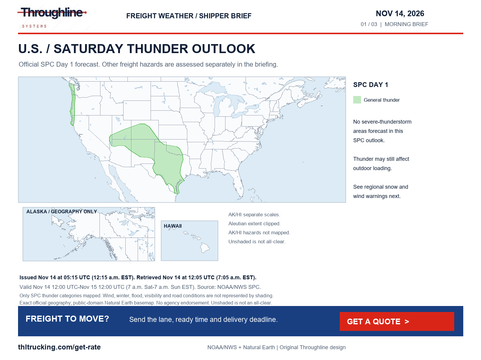
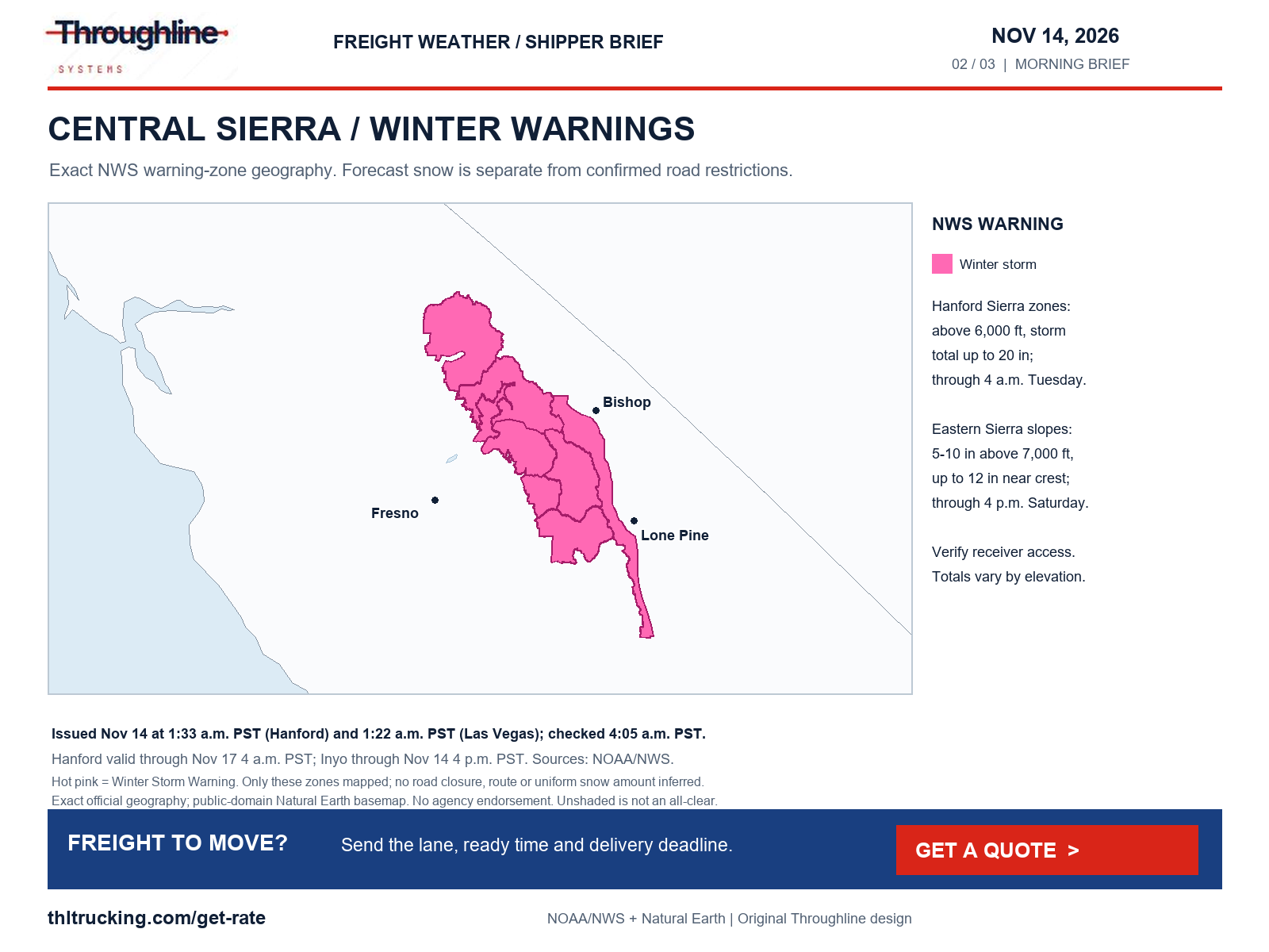
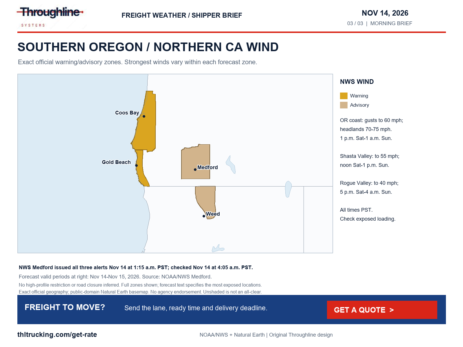
Sources: NWS national active-alert snapshot; SPC Day 1 convective outlook; WPC excessive rainfall outlook; WPC Winter Storm Severity Index
Sierra I-80: closed westbound to tractor-trailers, chains required after overnight snow (CA)
High risk · CA · I-80. What the official forecasts and warnings say:
Donner Summit, CA: Winter Storm Warning until Sat 7:00 AM ET (4 AM PST). NWS Sacramento expected up to one more inch of snow above 5,000 feet with slippery roads, chain controls and travel delays, then a lull through Sunday before more snow Sunday night into Monday.
The earlier NWS Reno Lake Tahoe warning stated an end time of 10 AM PST; it was absent from the 7:05 AM ET active-alert snapshot. Caltrans still listed the westbound truck closure at 4:05 AM page time.
Road restrictions confirmed on the official state DOT / 511 site at the time shown. A weather warning alone is not listed here.
- Do not plan a westbound tractor-trailer crossing of Donner Summit on the 4:05 AM Caltrans report. Ask the carrier whether it will hold in Reno until the closure lifts or reroute, and check Caltrans QuickMap before dispatch, because Sierra controls can lift or change at any time.
- Build extra transit time into any Sierra I-80 pickup or delivery while chains are required in both directions, and confirm a receiver contact who can move a Saturday appointment.
- Tarp and secure open-deck freight for wet snow, and plan Monday crossings around the more snow NWS Sacramento expects Sunday night into Monday.
| Route and location | Status | Official report |
|---|---|---|
| I-80 westbound, Nevada State Line to 4.7 mi west of Kingvale (Placer Co) (CA) | Closed: Closed westbound to all tractor-semitrailer combinations due to snow; Caltrans advises them to use an alternate route but does not name one. Separately, chains are required from Truckee to 4.7 mi west of Kingvale for all vehicles except 4-wheel-drive vehicles with snow tires on all 4 wheels. Caltrans also reports westbound trucks being screened 5 mi west of Reno at Mogul (Washoe Co): drivers must have maximum chains in their possession to proceed, and permit loads are prohibited. | Caltrans highway conditions, Saturday, November 14th, 2026 at 04:05 AM (page shows no time zone); retrieved Nov 14, 7:05 AM ET |
| I-80 eastbound, Kingvale (Placer Co) to the Nevada State Line (CA) | Chain control / traction law: Chains are required on all vehicles except 4-wheel-drive vehicles with snow tires on all 4 wheels. | Caltrans highway conditions, Saturday, November 14th, 2026 at 04:05 AM (page shows no time zone); retrieved Nov 14, 7:05 AM ET |
| I-80 westbound, Brake check area 0.5 mi west of Nyack (Placer Co) (CA) | Restricted (e.g. high-profile or light vehicles): All westbound trucks are required to stop at the brake check area to reduce the risk of brake fires. This is a truck inspection requirement, not a weather closure. | Caltrans highway conditions, Saturday, November 14th, 2026 at 04:05 AM (page shows no time zone); retrieved Nov 14, 7:05 AM ET |
Sources: NWS Winter Storm Warning: Lassen Volcanic National Park and more; NWS Winter Storm Warning: Greater Lake Tahoe Area; NWS point forecast: Donner Summit, CA; Caltrans highway conditions: I-80 westbound, Nevada State Line to 4.7 mi west of Kingvale (Placer Co); Caltrans highway conditions: I-80 eastbound, Kingvale (Placer Co) to the Nevada State Line; Caltrans highway conditions: I-80 westbound, Brake check area 0.5 mi west of Nyack (Placer Co)
Phoenix area: Gila River dam-release flooding and a weekend westbound I-10 closure (AZ)
Medium risk · AZ · I-10. What the official forecasts and warnings say:
Phoenix, AZ (Maricopa County): Flood Warning until Tue 1:00 PM ET (11 AM MST) for the upstream release from Painted Rock Dam on the Gila River. NWS Phoenix says releases peaking at 3,000 cfs are flooding farmland and low-water crossings along the Gila River in Maricopa and northeastern Yuma counties, which may not be passable; the warning does not name a freeway.
Road restrictions confirmed on the official state DOT / 511 site at the time shown. A weather warning alone is not listed here.
- For westbound I-10 freight leaving Phoenix toward Buckeye, Blythe and Southern California this weekend, ask the carrier how it will route around the Loop 303–Verrado Way closure; AZ511 gives no hours, so confirm before dispatch.
- For farms and facilities near the Gila River in western Maricopa and northeastern Yuma counties, ask the receiver whether the low-water crossings on its approach are open.
| Route and location | Status | Official report |
|---|---|---|
| I-10 westbound (Papago Freeway), Between Loop 303 and Verrado Way, west Phoenix area (AZ) | Closed: AZ511’s weekend alert: “I-10 WB (Papago Freeway) closed between Loop 303 and Verrado Way” for this weekend (Nov. 13–16). The alert gives no hours and says drivers should allow extra travel time and use detour routes as needed. Construction, not weather. | AZ511 alerts, Last updated Nov 12 2026, 6:31 PM (time zone not shown); retrieved Nov 14, 6:23 AM ET |
| I-17 northbound (Black Canyon Freeway), Between Loop 101 and Pinnacle Peak Road, north Phoenix (AZ) | Lane closure: AZ511’s weekend alert: “I-17 NB (Black Canyon Freeway) restricted to two lanes between Loop 101 and Pinnacle Peak Road” this weekend (Nov. 13–16); no hours given. Construction, not weather. | AZ511 alerts, Last updated Nov 12 2026, 6:31 PM (time zone not shown); retrieved Nov 14, 6:23 AM ET |
Sources: NWS Flood Warning: Maricopa, AZ; Yuma, AZ; AZ511 alerts: I-10 westbound (Papago Freeway), Between Loop 303 and Verrado Way, west Phoenix area; AZ511 alerts: I-17 northbound (Black Canyon Freeway), Between Loop 101 and Pinnacle Peak Road, north Phoenix
Southern Oregon and Shasta Valley I-5: wind from Saturday afternoon into Sunday (OR/CA)
Medium risk · OR, CA · I-5. What the official forecasts and warnings say:
Medford, OR: Wind Advisory Sat 8:00 PM – Sun 7:00 AM ET (5 PM – 4 AM PST). NWS Medford expects southeast gusts up to 40 mph in the Rogue Valley from southern Medford to Ashland, including portions of I-5, strongest around midnight.
Shasta Valley, CA (Weed, Grenada, Montague): NWS Medford Wind Advisory Sat 3:00 PM – Sun 4:00 PM ET (noon Saturday – 1 PM PST Sunday), with south winds of 25 to 35 mph and gusts up to 55 mph across portions of I-5, strongest tonight.
Road restrictions confirmed on the official state DOT / 511 site at the time shown. A weather warning alone is not listed here.
Caltrans QuickMap (CA) could not be read at Nov 14, 6:24 AM ET; check it directly before dispatch.
- Plan empty and high-profile trailers on I-5 through the Shasta Valley from Saturday noon PST and through the Rogue Valley Saturday night, and ask the carrier before dispatch whether it will hold during the strongest gusts tonight.
- Caltrans’ I-5 report could not be read as current this morning, so check QuickMap for the California side, and TripCheck for the Siskiyou Summit carry-chains rule, before dispatch.
| Route and location | Status | Official report |
|---|---|---|
| I-5, MP 1 to 11, Siskiyou Summit snow zone (California state line to the Talent exit) (OR) | Chain control / traction law: Snow-zone rule shown on TripCheck: “Carry chains or traction tires regardless of conditions.” The northbound and southbound Siskiyou Summit reporting stations showed intermittent showers and bare pavement. This is an informational carry rule, not an installed-chain order. | ODOT TripCheck, statewide road conditions, Snow-zone entry shows no timestamp; Siskiyou Summit stations last updated 11/13/2026 8:03 PM (time zone not shown); retrieved Nov 14, 6:23 AM ET |
Sources: NWS Wind Advisory: Jackson County; NWS Wind Advisory: Central Siskiyou County (Shasta Valley); ODOT TripCheck, statewide road conditions: I-5, MP 1 to 11, Siskiyou Summit snow zone (California state line to the Talent exit)
Mojave I-15 and I-40 near Barstow: wind advisory this morning (CA)
Medium risk · CA · I-15, I-40. What the official forecasts and warnings say:
Barstow, CA: Wind Advisory until Sat 1:00 PM ET (10 AM PST). NWS Las Vegas expects south winds of 20 to 30 mph with gusts up to 50 mph in the western Mojave Desert.
Caltrans QuickMap (CA) could not be read at Nov 14, 6:24 AM ET; check it directly before dispatch.
- Plan empty and high-profile trailers on I-15 and I-40 near Barstow around the advisory, which ends at 10 AM PST; a pickup after it ends may be the simpler plan.
- Caltrans listed no traffic restrictions on I-15 in Southern California at 3:00 AM; its I-40 report showed no entries and is treated as unread, so check QuickMap before dispatch.
Sources: NWS Wind Advisory: Death Valley National Park; Western Mojave Desert; NWS point forecast: Barstow, CA
Cheyenne I-25 and I-80: dense fog until mid-morning (WY)
Medium risk · WY · I-25, I-80. What the official forecasts and warnings say:
Cheyenne, WY: Dense Fog Advisory until Sat 11:00 AM ET (9 AM MST). NWS Cheyenne expects visibility of one quarter mile or less in central and east Laramie County, east Platte County and lower Converse County, and in Banner and Kimball counties in the Nebraska Panhandle.
Road restrictions confirmed on the official state DOT / 511 site at the time shown. A weather warning alone is not listed here.
- Expect slower morning running on I-25 from the Colorado line through Cheyenne toward Wheatland and Douglas until the fog lifts; WYDOT’s overnight segment reports showed fog on every I-25 segment from the Colorado line to Casper, with limited visibility between Wheatland and Exit 92.
- For oversize freight through Cheyenne, note WYDOT’s 16-foot width restriction on eastbound I-80 between Exit 359 and Exit 364.
| Route and location | Status | Official report |
|---|---|---|
| I-80 eastbound, MP 361.800 to 362.200, Exit 359 (I-25 junction) to Exit 364 (College Dr), Cheyenne (WY) | Restricted (e.g. high-profile or light vehicles): WYDOT lists a 16-foot width restriction while a jersey barrier is in place until guardrail is repaired. This matters for oversize loads; it is not a weather restriction. | WYDOT travel information, Interstate 80, Segment last reported Nov 13, 2026, 09:06 AM (time zone not shown); retrieved Nov 14, 6:23 AM ET |
Sources: NWS Dense Fog Advisory: Banner; Kimball; Converse County Lower Elevations; East Platte County; Central Laramie County and more; WYDOT travel information, Interstate 80: I-80 eastbound, MP 361.800 to 362.200, Exit 359 (I-25 junction) to Exit 364 (College Dr), Cheyenne
Colorado I-70: verify mountain conditions and conditional sun-glare detours (CO)
Medium risk · CO · I-70. What the official forecasts and warnings say:
The original review identified possible light mountain snow. The original gridded-forecast accumulation archive was not available for independent verification, so this update omits precise totals; check the current NWS point forecast and COtrip for the actual departure window.
COtrip (CO) could not be read at Nov 14, 6:37 AM ET; check it directly before dispatch.
- Ask the carrier to check current Colorado chain and traction-law status before climbing. COtrip’s live reports could not be read in the original review; no live restriction is inferred.
- Check COtrip or the carrier for any actual Floyd Hill detour before departure; do not assume the conditional schedule is active.
Sources: NWS point forecast: Vail Pass, CO; NWS point forecast: Eisenhower–Johnson Tunnel, CO
Anchorage and the Kenai Peninsula: winter storm watch from Saturday afternoon (AK)
Medium risk · AK. What the official forecasts and warnings say:
Anchorage, AK: Winter Storm Watch Sat 7:00 PM – Mon 7:00 AM ET (3 PM Saturday – 3 AM AKST Monday).
NWS Anchorage expects a snow band to set up and stall over Anchorage and the Kenai Peninsula from Saturday afternoon through Sunday, with 2 to 4 inches (low end) to 6 to 10 inches (high end) in Anchorage and Eagle River, 7 to 11 inches possible from Turnagain Pass to Moose Pass and 9 to 11 inches at Portage, before snow changes to rain from east to west Sunday afternoon. It says travel could be very difficult and confidence in amounts is lower because the band’s position is uncertain.
Alaska 511 (AK) could not be read at Nov 14, 6:23 AM ET; check it directly before dispatch.
- For Anchorage deliveries from Saturday evening through Monday morning, confirm a receiver contact who can move an appointment.
- Build extra transit time Sunday for freight through Turnagain Pass and Portage, where the watch has the highest totals; Alaska 511’s road-condition pages could not be read this morning.
Sources: NWS Winter Storm Watch: Anchorage; Anchorage Hillside / Eagle River; East Turnagain Arm; Portage; Southern Kachemak Bay and more; NWS point forecast: Anchorage, AK
Floods, coastal flooding and federal disaster declarations
Florida river flooding continues on the St. Johns River, where NWS Melbourne’s flood warnings remain in effect until further notice. Near Cocoa in Brevard County, Major flooding is occurring: the river stood at 17.1 feet Friday evening and is forecast to crest at 17.2 feet, a level at which NWS says the Providence Road area west of Cocoa becomes impassable. Above Lake Harney in Seminole County, Moderate flooding is occurring and levels are expected to stay nearly steady into next week, and warnings also continue near Sanford and near Astor. These are river levels, not DOT-reported road closures: confirm low-lying facility approaches in those counties.
In Arizona, NWS Phoenix’s flood warning for the release from Painted Rock Dam on the Gila River runs until 11 AM MST Tuesday (hot spot below). In Texas, NWS Corpus Christi forecasts minor flooding on the Nueces River near Tilden from Saturday evening to late Monday night, cresting at 15.0 feet early Sunday afternoon against a 14.0-foot flood stage. NWS Seattle’s flood watch for Mason County, Washington runs through late tonight, with 3 to 4 inches of rain forecast on the south slopes of the Olympics.
Coastal flooding: NWS Los Angeles has a Coastal Flood Warning for San Luis Obispo County and Santa Barbara central coast beaches from 3 AM to 6 PM PST Saturday, warning of significant flooding of coastal beaches, walkways and roads around high tide, with advisories for Ventura, Malibu and Los Angeles County beaches from 4 AM to 4 PM PST. NWS Mount Holly’s advisory for Ocean County, New Jersey runs until 4 PM EST and says some partial or full road closures are possible, with another for the Delaware beaches; further advisories cover the San Francisco and San Diego–Orange County shorelines and the San Juan Islands and western Whatcom County. These are forecasts of flooding, not DOT-reported closures.
OpenFEMA lists five declarations in the last 30 days: a major disaster for Hurricane Isaias in Florida (declared October 27), an emergency for severe storms and flooding in New Mexico (October 26), a fire management declaration for the Norte Fire in California (October 16), and emergencies for Typhoon Champi in Guam and Tropical Storm Champi in the Northern Mariana Islands (October 17). NHC lists no active tropical cyclones this morning.
Sources: NWS Flood Warning: St. Johns River near Cocoa (Brevard, FL); NWS Flood Warning: St. Johns River above Lake Harney (Seminole, FL); NWS Flood Warning: St. Johns River near Sanford (Seminole, FL); NWS Flood Warning: St. Johns River near Astor (Lake and Volusia, FL); NWS Flood Warning: Maricopa, AZ; Yuma, AZ; NWS Flood Warning: Nueces River near Tilden (McMullen, TX); NWS Flood Watch: Mason County, WA; NWS Coastal Flood Warning: San Luis Obispo and Santa Barbara central coast beaches; NWS Coastal Flood Advisory: Malibu Coast and Los Angeles County Beaches; NWS Coastal Flood Advisory: Ocean County, NJ; NWS national active-alert snapshot; FEMA DR-4955-FL: Hurricane Isaias (major disaster); FEMA EM-3660-NM: Severe storms and flooding (emergency); FEMA FM-5679-CA: Norte Fire (fire management); FEMA EM-3658-MP: Tropical Storm Champi (emergency); FEMA EM-3659-GU: Typhoon Champi (emergency); NHC active tropical cyclones
Diesel: EIA’s November 9 weekly average
EIA’s weekly retail price table, released November 10, puts U.S. on-highway diesel (all types, including taxes) at $6.127 per gallon for the week of November 9, down $0.165 from $6.292 on November 2. EIA lists November 17 as the next release. This run’s automated EIA feed did not load, so the figures were read from EIA’s page.
A national weekly average is a budgeting reference, not the fuel cost of a particular FTL, partial or expedited move. Ask which fuel week and surcharge basis a quote uses before comparing totals.
| Measure | EIA value |
|---|---|
| U.S. on-highway diesel, week of November 9 | $6.127 per gallon, taxes included |
| Previous week, November 2 | $6.292 per gallon |
| Weekly change | Down $0.165 per gallon |
| Release / next scheduled release | November 10 / November 17, 2026 |
Sources: EIA U.S. gasoline and diesel retail prices (weekly)
Government transport notice: Floyd Hill sun-glare planning
Separate construction/access planning: CDOT’s October 16 release describes conditional sun-glare safety detours on eastbound I-70 at Floyd Hill, decided case by case on bright mornings from sunrise to 8:30 a.m. in early November–February. This is a published schedule, not confirmation that a detour is active today; weekend operation is not specified.
This October 16 government notice is earlier seasonal access guidance reviewed today, not a new closure announcement. For early eastbound deliveries into Denver, give receiving the carrier’s current ETA and check whether a detour is actually active before revising an appointment. The original review could not read COtrip’s live incident data.
Sources: CDOT: Sun glare safety detours return to eastbound I-70 at Floyd Hill
Coverage and limits of this morning’s review
The original review at 6:15 AM ET used NWS alerts and point forecasts, SPC, WPC, NHC and OpenFEMA. The independent 7:05 AM ET review archived fresh NWS active alerts, SPC Day 1 polygons/discussion, WPC excessive-rainfall and winter-weather discussions, and selected DOT reports. The original gridded-point archive was unavailable for independent verification, so precise point accumulation/gust totals and sampled-point risk counts have been removed. Diesel figures were checked against EIA’s public weekly table.
California: Caltrans’ I-80 report (as of 4:05 AM Saturday; the page shows no time zone) listed the westbound truck closure, chain controls in both directions, westbound truck screening at Mogul, Nevada, and the westbound brake check near Nyack shown in the Sierra hot spot. Its I-15 report (3:00 AM) said no traffic restrictions are reported for Southern California. Its I-40 report (3:24 AM) showed a region heading with no entries and no “no restrictions” line, so it is treated as unread, and its I-5 report returned an out-of-date November 8 report, so no I-5 claim is made from Caltrans. Oregon: TripCheck’s statewide report loaded; its only I-5 items near Medford and Ashland are the Siskiyou Summit carry-chains rule and the NWS wind advisory repeated as an alert.
Arizona: AZ511’s alert list showed the weekend Phoenix-area closures in the Phoenix hot spot and the SR 89A closure between about mileposts 387 and 390 for repairs to flood-damaged highway (last updated Nov 11, 5:54 PM), which is not on this briefing’s corridors. Wyoming: WYDOT’s I-25 page showed fog on every segment from the Colorado line to Casper with no restrictions on those segments near Cheyenne; its I-80 page listed the Cheyenne width restriction, but its segment reports were last updated Friday morning. Colorado: COtrip’s critical-reports page returned only an app shell, so no live I-70 status is claimed; CDOT’s October 16 release on the Floyd Hill sun-glare detours is a conditional published schedule and has been removed from the confirmed-restriction table. Alaska: Alaska 511’s alert list said “There are no alerts at this time,” but its road-conditions and Anchorage pages returned only an app shell.
This review is selective. It cannot certify every road, crash, construction zone or closure, and conditions change after a snapshot. Forecasts, warnings and outlooks are not closures; only restrictions an official DOT / 511 page listed appear as restrictions. Check the state site directly before dispatch.
Independent 7:05 AM ET category check covered high winds, severe thunderstorms/tornadoes/hail, snow/blizzard/freezing precipitation, flooding, fog, smoke, dust, fire weather and non-weather transport incidents. The fresh NWS alert feed contained dense fog advisories, but no alerts named Dust, Smoke or Air Quality; this only describes that feed, not an all-clear for visibility or road surfaces. SPC’s fire-weather outlook and WPC winter/excessive-rainfall products were reviewed separately. Selected Caltrans, WYDOT and MDOT road reports were also checked; app-shell or unavailable feeds remain coverage gaps.
Sources: NWS national active-alert snapshot; SPC Day 1 convective outlook; WPC excessive rainfall outlook; WPC Winter Storm Severity Index; NHC active tropical cyclones; EIA U.S. gasoline and diesel retail prices (weekly); Caltrans I-80 highway conditions; Caltrans I-15 highway conditions; Caltrans I-40 highway conditions; Caltrans I-5 highway conditions; ODOT TripCheck statewide road conditions; AZ511 alerts list; WYDOT travel information: Interstate 25; WYDOT travel information: Interstate 80; Alaska 511 alerts list; CDOT: Sun glare safety detours return to eastbound I-70 at Floyd Hill
Sources and editorial notes
Original analysis by Throughline Systems. Source links may show newer releases after this article’s publication; the observation and issue dates below identify the material used. Agency citations do not imply endorsement.
- NWS national active-alert snapshot
National active-alert snapshot retrieved November 14 at 7:05 AM ET; individual alert issue/valid periods retained
Accessed .
- SPC Day 1 convective outlook
Issued November 14 at 05:15 UTC; valid November 14 12:00 UTC–November 15 12:00 UTC; general thunder only, no severe areas
Accessed .
- WPC excessive rainfall outlook
Discussion issued November 14 at 3:16 AM EST; Day 1 valid November 14 12:00 UTC–November 15 12:00 UTC
Accessed .
- WPC Winter Storm Severity Index
Day 1 retrieved November 14 at 6:15 AM ET; highest impact: MODERATE
Accessed .
- NWS Winter Storm Warning: Lassen Volcanic National Park and more
Issued 2026-11-14T01:26:00-08:00; valid until 2026-11-14T04:00:00-08:00
Accessed .
- NWS Winter Storm Watch: Anchorage; Anchorage Hillside / Eagle River; East Turnagain Arm; Portage; Southern Kachemak Bay and more
Issued 2026-11-13T21:22:00-09:00; valid until 2026-11-16T03:00:00-09:00
Accessed .
- NWS point forecast: Anchorage, AK
Gridded forecast retrieved November 14 at 6:15 AM ET, next 36 hours
Accessed .
- NWS Dense Fog Advisory: Banner; Kimball; Converse County Lower Elevations; East Platte County; Central Laramie County and more
Issued 2026-11-14T02:25:00-07:00; valid until 2026-11-14T09:00:00-07:00
Accessed .
- NWS Flood Warning: Maricopa, AZ; Yuma, AZ
Issued 2026-11-13T19:24:00-07:00; valid until 2026-11-17T11:00:00-07:00
Accessed .
- NWS point forecast: Vail Pass, CO
Gridded forecast retrieved November 14 at 6:15 AM ET, next 36 hours
Accessed .
- NWS point forecast: Eisenhower–Johnson Tunnel, CO
Gridded forecast retrieved November 14 at 6:15 AM ET, next 36 hours
Accessed .
- NWS Wind Advisory: Death Valley National Park; Western Mojave Desert
Issued 2026-11-14T01:20:00-08:00; valid until 2026-11-14T10:00:00-08:00
Accessed .
- NWS Wind Advisory: Jackson County
Issued 2026-11-14T01:15:00-08:00; valid until 2026-11-15T04:00:00-08:00
Accessed .
- NWS point forecast: Donner Summit, CA
Gridded forecast retrieved November 14 at 6:15 AM ET, next 36 hours
Accessed .
- NWS point forecast: Barstow, CA
Gridded forecast retrieved November 14 at 6:15 AM ET, next 36 hours
Accessed .
- NWS point forecast: Dallas–Fort Worth, TX
Gridded forecast retrieved November 14 at 6:15 AM ET, next 36 hours
Accessed .
- NWS point forecast: Abilene, TX
Gridded forecast retrieved November 14 at 6:15 AM ET, next 36 hours
Accessed .
- NWS point forecast: Houston, TX
Gridded forecast retrieved November 14 at 6:15 AM ET, next 36 hours
Accessed .
- NWS Winter Storm Warning: Greater Lake Tahoe Area
Issued 2026-11-14T01:35:00-08:00; valid until 2026-11-14T10:00:00-08:00
Accessed .
- NWS Winter Storm Warning: Mono County
Issued 2026-11-14T01:35:00-08:00; valid until 2026-11-14T10:00:00-08:00
Accessed .
- NWS Winter Storm Warning: southern Sierra Nevada above 6,000 feet (Yosemite, Kings Canyon, Sequoia)
Issued 2026-11-14T01:33:00-08:00; valid until 2026-11-17T04:00:00-08:00
Accessed .
- NWS Winter Storm Warning: Eastern Sierra Slopes of Inyo County
Issued 2026-11-14T01:22:00-08:00; valid until 2026-11-14T16:00:00-08:00
Accessed .
- NWS Wind Advisory: Central Siskiyou County (Shasta Valley)
Issued 2026-11-14T01:15:00-08:00; valid 2026-11-14T12:00:00-08:00 through 2026-11-15T13:00:00-08:00
Accessed .
- NWS High Wind Warning: South Central Oregon Coast and Curry County Coast
Issued 2026-11-14T01:15:00-08:00; valid 2026-11-14T13:00:00-08:00 through 2026-11-15T01:00:00-08:00
Accessed .
- NWS Wind Advisory: Northern Washington Coast and Grays Harbor County Coast
Issued 2026-11-13T21:11:00-08:00; valid 2026-11-14T16:00:00-08:00 through 2026-11-15T04:00:00-08:00
Accessed .
- NWS Blizzard Warning: Northern Arctic Coast, Alaska
Issued 2026-11-13T14:59:00-09:00; valid until 2026-11-15T07:00:00-09:00
Accessed .
- NWS Winter Weather Advisory: Tennessee southern Appalachians above 3,000 feet
Issued 2026-11-14T01:16:00-05:00; valid until 2026-11-14T13:00:00-05:00
Accessed .
- NWS Dense Fog Advisory: Slope, Hettinger, Bowman and Adams counties, ND
Issued 2026-11-14T03:48:00-06:00; valid until 2026-11-14T12:00:00-06:00
Accessed .
- NWS Coastal Flood Warning: San Luis Obispo and Santa Barbara central coast beaches
Issued 2026-11-13T17:35:00-08:00; valid 2026-11-14T03:00:00-08:00 through 2026-11-14T18:00:00-08:00
Accessed .
- NWS Coastal Flood Advisory: Malibu Coast and Los Angeles County Beaches
Issued 2026-11-13T17:35:00-08:00; valid 2026-11-14T04:00:00-08:00 through 2026-11-14T16:00:00-08:00
Accessed .
- NWS Coastal Flood Advisory: Ocean County, NJ
Issued 2026-11-14T03:41:00-05:00; valid until 2026-11-14T16:00:00-05:00
Accessed .
- NWS Flood Warning: St. Johns River near Cocoa (Brevard, FL)
Issued 2026-11-13T20:29:00-05:00; in effect until further notice
Accessed .
- NWS Flood Warning: St. Johns River above Lake Harney (Seminole, FL)
Issued 2026-11-13T20:35:00-05:00; in effect until further notice
Accessed .
- NWS Flood Warning: St. Johns River near Sanford (Seminole, FL)
Issued 2026-11-13T20:40:00-05:00; in effect until further notice
Accessed .
- NWS Flood Warning: St. Johns River near Astor (Lake and Volusia, FL)
Issued 2026-11-13T20:21:00-05:00; in effect until further notice
Accessed .
- NWS Flood Warning: Nueces River near Tilden (McMullen, TX)
Issued 2026-11-13T20:06:00-06:00; valid 2026-11-14T19:12:00-06:00 through 2026-11-17T01:00:00-06:00
Accessed .
- NWS Flood Watch: Mason County, WA
Issued 2026-11-14T03:11:00-08:00; valid until 2026-11-15T04:00:00-08:00
Accessed .
- NHC active tropical cyclones
Retrieved November 14 at 6:15 AM ET; no active tropical cyclones listed
Accessed .
- FEMA DR-4955-FL: Hurricane Isaias (major disaster)
Declared 2026-10-27 (OpenFEMA declarations, last 30 days)
Accessed .
- FEMA EM-3660-NM: Severe storms and flooding (emergency)
Declared 2026-10-26 (OpenFEMA declarations, last 30 days)
Accessed .
- FEMA FM-5679-CA: Norte Fire (fire management)
Declared 2026-10-16 (OpenFEMA declarations, last 30 days)
Accessed .
- FEMA EM-3658-MP: Tropical Storm Champi (emergency)
Declared 2026-10-17 (OpenFEMA declarations, last 30 days)
Accessed .
- FEMA EM-3659-GU: Typhoon Champi (emergency)
Declared 2026-10-17 (OpenFEMA declarations, last 30 days)
Accessed .
- EIA U.S. gasoline and diesel retail prices (weekly)
Release date 11/10/2026; week of 11/09/26 vs 11/02/26; next release 11/17/2026; dollars per gallon including taxes
Accessed .
- Caltrans I-80 highway conditions
Latest report November 14 at 04:05 AM; page does not state time zone
Accessed .
- Caltrans I-15 highway conditions
Report as of Saturday, November 14th, 2026 at 03:00 AM (page shows no time zone)
Accessed .
- Caltrans I-40 highway conditions
Report as of Saturday, November 14th, 2026 at 03:24 AM (page shows no time zone); no entries shown
Accessed .
- Caltrans I-5 highway conditions
Returned a report dated Sunday, November 8th, 2026 at 05:34 AM; not current, so not used
Accessed .
- ODOT TripCheck statewide road conditions
Each entry carries its own Last Updated time (time zone not shown); no report-wide timestamp
Accessed .
- AZ511 alerts list
Weekend Phoenix-area closures alert last updated Nov 12 2026, 6:31 PM (time zone not shown)
Accessed .
- WYDOT travel information: Interstate 25
Each segment carries its own last report time (time zone not shown); latest Nov 14, 2026, 04:22 AM
Accessed .
- WYDOT travel information: Interstate 80
Each segment carries its own last report time (time zone not shown); latest Nov 13, 2026, 09:48 AM
Accessed .
- Alaska 511 alerts list
Page text: “There are no alerts at this time”; no timestamp shown
Accessed .
- CDOT: Sun glare safety detours return to eastbound I-70 at Floyd Hill
News release dated Oct. 16, 2026; seasonal schedule, no live status
Accessed .
- NWS Winter Storm Warning: Yosemite NP outside of the valley; San Joaquin River Canyon; Upper San Joaquin River; Kaiser to Rodgers Ridge; Kings Canyon NP; Grant Grove Area; Sequoia NP
Issued 2026-11-14T01:33:00-08:00; valid 2026-11-14T01:33:00-08:00 through 2026-11-17T04:00:00-08:00
Accessed .
- NWS Winter Storm Warning: Eastern Sierra Slopes of Inyo County
Issued 2026-11-14T01:22:00-08:00; valid 2026-11-14T01:22:00-08:00 through 2026-11-14T16:00:00-08:00
Accessed .
- NWS High Wind Warning: South Central Oregon Coast; Curry County Coast
Issued 2026-11-14T01:15:00-08:00; valid 2026-11-14T13:00:00-08:00 through 2026-11-15T01:00:00-08:00
Accessed .
- NWS Wind Advisory: Jackson County
Issued 2026-11-14T01:15:00-08:00; valid 2026-11-14T17:00:00-08:00 through 2026-11-15T04:00:00-08:00
Accessed .
- NWS Wind Advisory: Central Siskiyou County
Issued 2026-11-14T01:15:00-08:00; valid 2026-11-14T12:00:00-08:00 through 2026-11-15T13:00:00-08:00
Accessed .
- Caltrans highway conditions: I-80 westbound, Nevada State Line to 4.7 mi west of Kingvale (Placer Co)
Closed as reported Saturday, November 14th, 2026 at 04:05 AM (page shows no time zone)
Accessed .
- Caltrans highway conditions: I-80 eastbound, Kingvale (Placer Co) to the Nevada State Line
Chain control / traction law as reported Saturday, November 14th, 2026 at 04:05 AM (page shows no time zone)
Accessed .
- Caltrans highway conditions: I-80 westbound, Brake check area 0.5 mi west of Nyack (Placer Co)
Restricted (e.g. high-profile or light vehicles) as reported Saturday, November 14th, 2026 at 04:05 AM (page shows no time zone)
Accessed .
- AZ511 alerts: I-10 westbound (Papago Freeway), Between Loop 303 and Verrado Way, west Phoenix area
Closed as reported Last updated Nov 12 2026, 6:31 PM (time zone not shown)
Accessed .
- AZ511 alerts: I-17 northbound (Black Canyon Freeway), Between Loop 101 and Pinnacle Peak Road, north Phoenix
Lane closure as reported Last updated Nov 12 2026, 6:31 PM (time zone not shown)
Accessed .
- ODOT TripCheck, statewide road conditions: I-5, MP 1 to 11, Siskiyou Summit snow zone (California state line to the Talent exit)
Chain control / traction law as reported Snow-zone entry shows no timestamp; Siskiyou Summit stations last updated 11/13/2026 8:03 PM (time zone not shown)
Accessed .
- WYDOT travel information, Interstate 80: I-80 eastbound, MP 361.800 to 362.200, Exit 359 (I-25 junction) to Exit 364 (College Dr), Cheyenne
Restricted (e.g. high-profile or light vehicles) as reported Segment last reported Nov 13, 2026, 09:06 AM (time zone not shown)
Accessed .