November 15 logistics briefing: coastal Texas rain, Sierra snow ahead and a fresh I-80 check
Sunday shipper briefing: latest weekly diesel, Los Angeles October cargo, coastal Texas storms, Sierra snow timing, fog and confirmed road restrictions.
By Throughline Systems · · 10 min read
What matters for your next load
- Caltrans lists no Sierra I-80 restrictions at 4:04 a.m. PST; a new snow advisory begins later Sunday. Recheck before release.
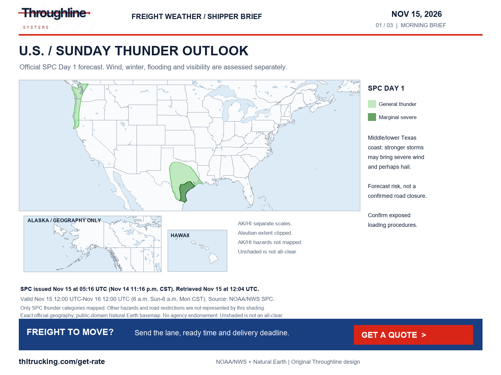
- Coastal Texas has forecast heavy-rain and severe-storm risk; morning fog is a separate issue across parts of the High Plains.
- EIA’s latest weekly U.S. diesel observation remains November 9 at $6.127 per gallon; October port volumes are context, not a live delay report.
Sunday decision: update the road status, then plan for the next weather window
This briefing was researched on November 15, 2026, beginning at 7:04 a.m. EST. It is a dated planning snapshot for manufacturers, lumber suppliers and distributors arranging full truckload, partial, open-deck, enclosed or expedited shipments. Conditions can change before a truck reaches the affected area.
The most useful change from Saturday evening is on California I-80: the 4:04 a.m. PST Caltrans report lists no restrictions in the Sierra section. Last night’s westbound tractor-semitrailer closure is no longer listed in that report. That is a current agency status, not a promise that the route will remain unrestricted: a new Sierra snow advisory begins later Sunday.
On the Texas coast, forecast heavy rain and stronger thunderstorms call for a receiving-window and exposed-loading check. Morning fog across parts of the central and southern High Plains is a separate hazard. Keep the carrier’s current position, the facility’s actual access and the next check-in time together when deciding whether to release freight.
Sources: Caltrans I-80 conditions; NWS active alerts: national snapshot; SPC Day 1 convective outlook; WPC excessive rainfall discussion
Diesel: latest weekly benchmark is $6.127 per gallon
EIA’s latest available U.S. on-highway diesel observation is November 9, 2026: $6.127 per gallon including taxes, down $0.165 from $6.292 on November 2. This is weekly pump-price data. There is no new Sunday diesel reading in the retrieved update.
Use the observation date and the agreed fuel-surcharge formula when reviewing a quote or invoice. A lower national weekly benchmark does not establish a matching reduction in a specific lane’s freight price. Equipment availability, shipment configuration, appointment constraints and the accepted commercial terms still matter.
| Region | November 9, dollars/gallon | Change from November 2, dollars/gallon |
|---|---|---|
| U.S. | 6.127 | -0.165 |
| Midwest | 6.201 | -0.201 |
| Gulf Coast | 5.741 | -0.171 |
| West Coast | 7.110 | -0.162 |
Sources: EIA: Gasoline and Diesel Fuel Update
Port news: October Los Angeles volume is a planning signal, not a delay report
The Port of Los Angeles’s November 12 release reports 1,026,872 TEUs handled in October 2026, its second consecutive month above one million. Loaded imports were approximately 538,620 TEUs; loaded exports were 114,981 TEUs. These are monthly container statistics for this port, not a measurement of today’s terminal queue or nationwide freight demand.
For a distributor arranging a domestic truck move after an import or transload, obtain the actual cargo-release status and the warehouse’s ready time before committing the onward pickup. The useful action is to connect the terminal or transload handoff with the domestic receiving appointment. The volume release alone does not prove a delay, shortage or rate increase.
Texas coast: separate rainfall risk, severe-storm risk and wind advisories
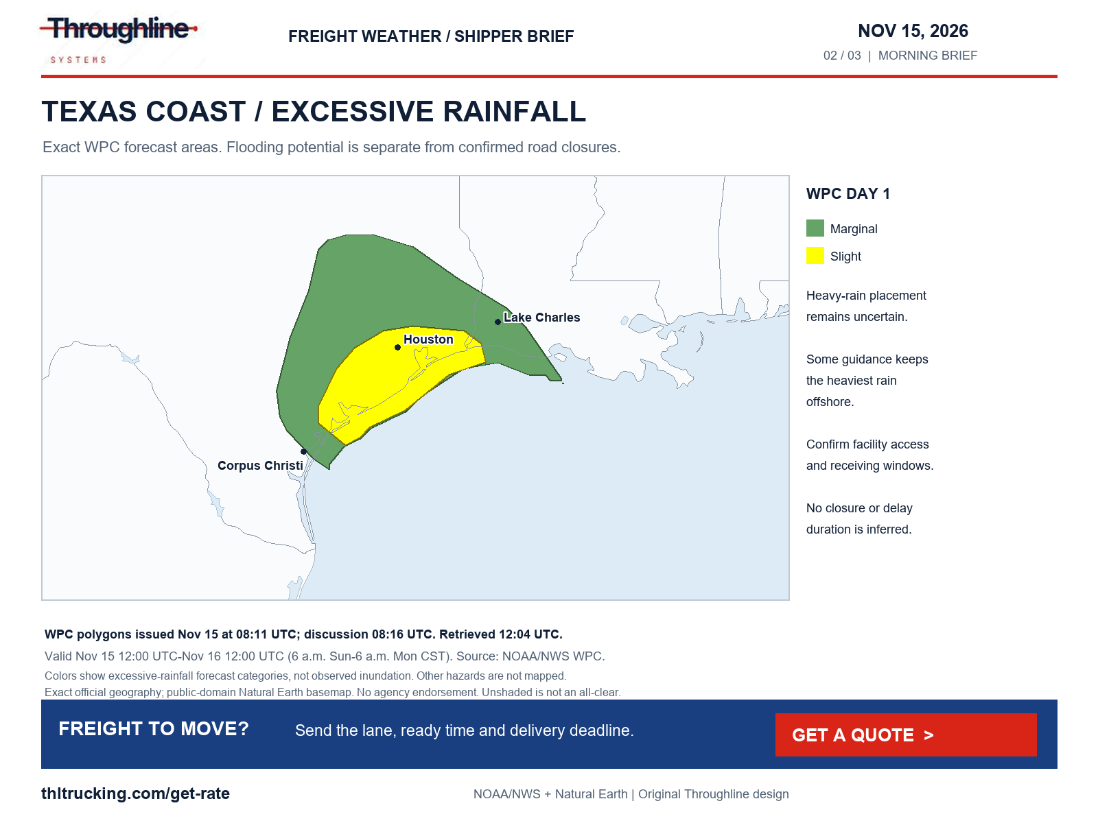
WPC’s 3:16 a.m. EST November 15 discussion retains a Slight excessive-rainfall risk for parts of coastal Texas for 6 a.m. CST Sunday through 6 a.m. CST Monday. It also describes uncertainty about how much of the heaviest rain reaches land, with some guidance placing it over the Gulf. This is forecast flooding potential, not confirmation that a road or loading yard is flooded.
SPC’s outlook issued at 11:16 p.m. CST November 14, valid for the same 24-hour period, places middle and lower Texas coastal areas in a Marginal severe-thunderstorm risk. Stronger storms may produce severe wind and perhaps hail. The discussion describes early conditional tornado potential tending to shift offshore; it does not establish an observed tornado or a road closure.
NWS Houston/Galveston’s November 14 8:35 p.m. CST wind advisory forecasts northeast winds of 20–25 mph with gusts to 35 mph across the listed inland/coastal counties, from 9 a.m. Sunday to 3 p.m. Monday CST. Its separate island/peninsula advisory has gusts to 40 mph through 6 p.m. Monday. Confirm outdoor loading and freight-protection procedures with the facility; these advisories do not establish a high-profile vehicle restriction.
Before an open-deck pickup or a time-sensitive delivery, identify who can stop exposed work, where freight can remain protected, and who can revise the receiving window. The retrieved DriveTexas page did not provide a usable incident list, so this briefing does not certify any Texas highway as open or propose a detour.
Sources: WPC excessive rainfall discussion; SPC Day 1 convective outlook; NWS active alerts: national snapshot
Sierra: morning I-80 status and Sunday-night snow are different facts
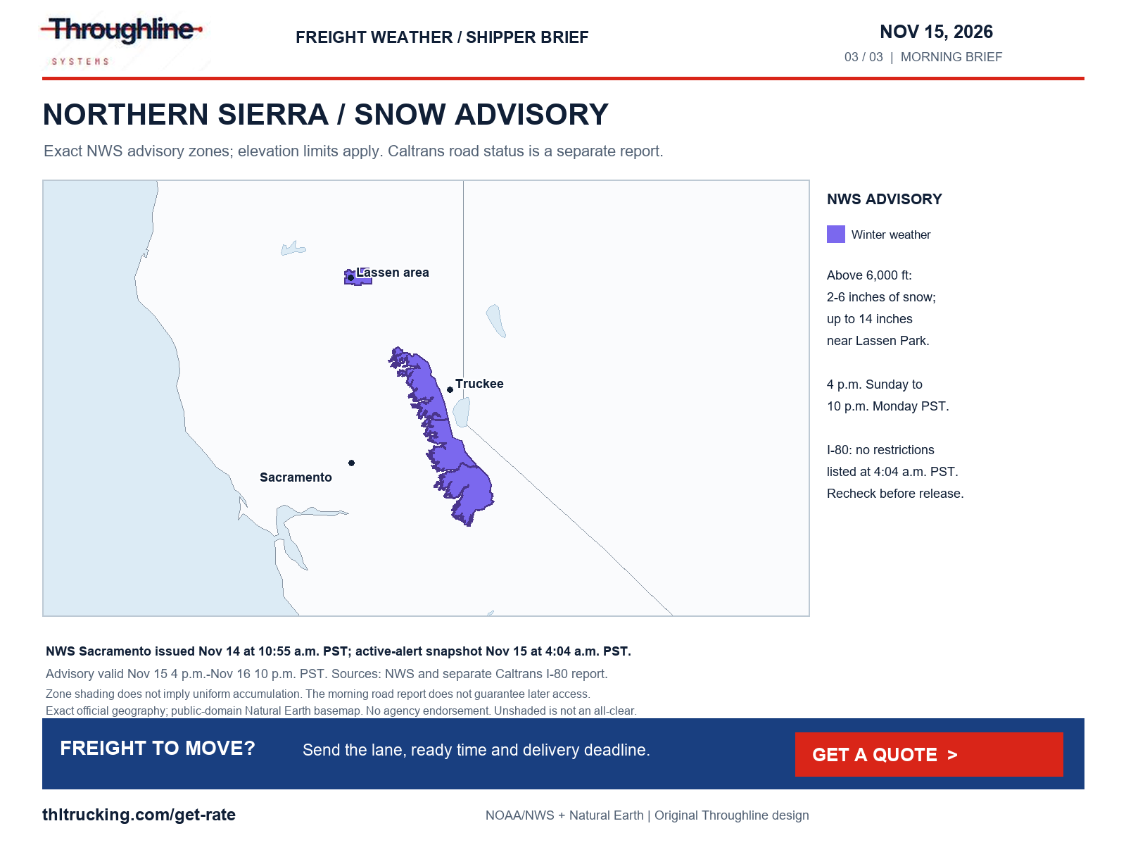
Caltrans lists no traffic restrictions in its northern California/Sierra I-80 section as of November 15 at 4:04 a.m. PST. Recheck that live report before release and again as conditions develop; do not carry forward last night’s closure as if it were still current.
NWS Sacramento’s advisory issued November 14 at 10:55 a.m. PST applies from 4 p.m. Sunday to 10 p.m. Monday PST. For the listed northern Sierra and southern Cascades areas above 6,000 feet, it forecasts 2–6 inches of snow, with up to 14 inches near Lassen Park, and gusts as high as 40 mph. Amounts are elevation-dependent and apply to the advisory period, not to every point inside the mapped zones.
NWS Reno’s November 15 2:04 a.m. PST advisory separately covers the Greater Lake Tahoe area above 7,000 feet from 10 p.m. Sunday to 7 p.m. Monday PST: 3–7 inches, highest west of Highway 89, and up to one inch near lake level. Ridgetop gusts to 70 mph are a ridge forecast, not a measured highway gust or an automatic truck restriction.
For Monday production freight, agree on the next road-status check and a receiving contingency before the office handoff. WPC’s 3:01 a.m. EST discussion, valid through Wednesday morning, also flags additional western mountain snow. Do not translate the broader multi-day forecast into an unsupported delay duration.
Sources: Caltrans I-80 conditions; NWS active alerts: national snapshot; WPC heavy snow and icing discussion
Morning visibility and other wind hazards remain part of the release check
NWS Amarillo advisories issued at 5:06 a.m. CST November 15 cover the Texas and Oklahoma Panhandles through noon CST, with visibility around one-quarter mile. NWS Albuquerque’s 3:53 a.m. MST advisories cover eastern New Mexico counties through 11 a.m. MST for dense fog, and the West Central Plateau through 9 a.m. MST for freezing fog. The latter warns of a thin ice layer on elevated surfaces such as overpasses.
Dense-fog advisories also cover parts of eastern Colorado, western Kansas, southeastern Wyoming and the Nebraska Panhandle in this morning’s national snapshot, with different local expiration times. Ask the carrier to check the local warning and actual road report for its position rather than treating a regional warning as a uniform corridor condition.
Wind review extends beyond thunderstorms: NWS Pendleton’s November 14 7:58 p.m. PST advisories forecast gusts up to 50 mph in the Grande Ronde Valley and northern Blue Mountain foothills through 7 a.m. PST Sunday. NWS Lake Charles forecasts gusts to 35 mph in listed southeast Texas and southwest/south-central Louisiana areas from 9 a.m. Sunday to noon Monday CST. Alaska alerts were reviewed separately; the national map’s Alaska and Hawaii insets are geographic orientation only.
Sources: NWS active alerts: national snapshot
Non-weather transport checks: construction, bridge damage and crashes
The independent road review found restrictions that should not be attributed to the weather forecast. The table reports the agencies’ location wording and the snapshot used; it does not identify a suitable alternate route for a particular vehicle or load.
MDOT’s incident feed at the morning check marks the westbound I-696 crash after M-10 in Oakland County as cleared at 7:00 a.m. Its presence in the feed is not a reason to call that crash an active lane closure. The broader construction feed was also reviewed; an empty incident search elsewhere would not establish that all roads are clear.
| Location | Official status in retrieved report | Timing and shipper action |
|---|---|---|
| SR 47, Harbor Boulevard to Ferry Street, Los Angeles County | Caltrans reports a construction closure, 24 hours daily through 6 a.m. February 29, 2028. | Report November 15, 4:04 a.m. PST. Confirm the local access plan with the carrier and facility. |
| I-80 vicinity, Higley Boulevard overpass, Exit 214 near Rawlins, Wyoming | WYDOT reports the overpass closed because of bridge damage. This is not a statement that I-80 through lanes are closed. | Retrieved 7:04 a.m. EST; page latest-update label 4:53 a.m., zone not printed. Check whether local access uses this overpass. |
| I-80 eastbound near Evanston, Wyoming, milepost 9 | WYDOT reports a crash blocking the right lane. | Retrieved 7:04 a.m. EST. Obtain a fresh carrier status; no quantified delay or reopening time is supplied here. |
Sources: Caltrans SR 47 conditions; WYDOT I-80 report; MDOT Mi Drive incident feed
Turn the briefing into one usable shipment handoff
For FTL or partial freight, send the actual lane, ready time, dimensions, gross weight, equipment needs, loading method and receiver’s accepted window. For lumber and building materials, identify the required protection and whether outdoor loading is exposed. For enclosed or expedited sprinter requests, confirm the actual cargo fit and handling arrangements instead of assuming urgency resolves those constraints.
Keep three times distinct: when freight will be ready, when the carrier expects to arrive, and when the receiver has agreed to accept it. Record the person authorized to change each time. Throughline’s public Get a quote form is the next step for review of a shipment; submitting a request does not confirm capacity, a booking or a delivery guarantee.
- Ask for the next status-check time, not an unsupported delay estimate.
- Recheck official restrictions for the actual vehicle and load before release.
- Give the carrier and receiver the same shipment reference and change contact.
Sources:
Coverage and limits of this morning’s review
All categories were screened: high winds and gust forecasts; severe thunderstorms, hail and tornado potential; snow, blowing snow, blizzard and freezing precipitation; flooding; fog, freezing fog, smoke and dust; and independent crashes, construction, bridge damage and other reported restrictions. National NWS alerts, SPC convective/fire outlooks, WPC rain/winter products and selected state DOT/511 reports form the evidence set.
No smoke or dust alert category appeared in the retrieved national alert set; that scoped finding is not an all-clear. Selected state pages expose only JavaScript shells, and some Washington and rail-source retrievals failed. A full nationwide road-incident inventory was not available. Port monthly volumes do not substitute for terminal-specific access reports.
The three original maps use current official polygons and public-domain Natural Earth geographic data with the approved Throughline wordmark. Wind and visibility findings are described in text rather than implied by unshaded map areas. Forecast risk, observed conditions and confirmed transport restrictions remain separate throughout.
Sources: NWS active alerts: national snapshot; SPC Day 1 convective outlook; WPC excessive rainfall discussion; WPC heavy snow and icing discussion; SPC fire weather outlook
Sources and editorial notes
Original analysis by Throughline Systems. Source links may show newer releases after this article’s publication; the observation and issue dates below identify the material used. Agency citations do not imply endorsement.
- EIA: Gasoline and Diesel Fuel Update
November 9, 2026 weekly U.S. on-highway diesel observation; dollars per gallon, including taxes; comparison November 2
Accessed .
- SPC Day 1 convective outlook
Issued November 14, 2026 at 11:16 p.m. CST; valid November 15 6 a.m.–November 16 6 a.m. CST
Accessed .
- WPC excessive rainfall discussion
Issued November 15, 2026 at 3:16 a.m. EST; Day 1 valid November 15 12:00 UTC–November 16 12:00 UTC
Accessed .
- WPC heavy snow and icing discussion
Issued November 15, 2026 at 3:01 a.m. EST; valid November 15 12:00 UTC–November 18 12:00 UTC
Accessed .
- NWS active alerts: national snapshot
Retrieved November 15, 2026 at 7:04 a.m. EST; individual issue and valid periods stated in text
Accessed .
- Caltrans I-80 conditions
Agency report November 15, 2026 at 4:04 a.m. PST; California I-80
Accessed .
- Caltrans SR 47 conditions
Agency report November 15, 2026 at 4:04 a.m. PST; Los Angeles County
Accessed .
- WYDOT I-80 report
Retrieved November 15, 2026 at 7:04 a.m. EST; page latest update label 4:53 a.m., no time zone printed
Accessed .
- MDOT Mi Drive incident feed
Retrieved November 15, 2026 at 7:04 a.m. EST; Oakland County crash marked cleared at 7:00 a.m.
Accessed .
- Port of Los Angeles: October container report
Released November 12, 2026; October 2026 container volume, twenty-foot equivalent units (TEUs)
Accessed .
- SPC fire weather outlook
Current outlook retrieved November 15, 2026; forecast screening, not a transport closure feed
Accessed .