November 16 logistics briefing: I-80 chain controls, western snow and Monday freight decisions
Monday shipper briefing: confirmed I-80 controls, western mountain snow, wind and fog, Tuesday Florida rain, latest weekly diesel and Los Angeles cargo context.
By Throughline Systems · · 12 min read
What matters for your next load
- Caltrans confirms Sierra I-80 chain controls and truck screening; a separate westbound collision closure affects Emeryville.
- Western snow, Gulf Coast wind and morning fog need facility and carrier checks; Florida rainfall risk increases Tuesday.
- Latest retrieved EIA diesel is the November 9 weekly observation: $6.127 per gallon. Port October volume is context, not a current delay report.
Monday release plan: verify I-80 controls before confirming the appointment
This November 16 briefing uses primary reports retrieved beginning at 7:01 a.m. EST. The clearest operational change is in California: Caltrans now lists Sierra I-80 chain controls, truck screening and permit-load prohibitions, plus a separate westbound crash closure in Emeryville. These are confirmed agency reports at the stated time; they can change before a shipment reaches them.
For manufacturers, lumber suppliers and distributors, the decision is whether freight should leave its origin now, wait for a carrier status check, or receive a revised delivery appointment. Ask the carrier which current restrictions apply to its equipment and load, then give the receiver a specific next-update time. Neither the snow forecast nor this briefing establishes a safe alternate route.
Western mountain snow, Gulf Coast winds and morning fog deserve attention even though SPC has no organized thunderstorm area forecast today. Tuesday’s Florida rain outlook is a separate planning window. Keep weather advisories, forecast probabilities and transport restrictions distinct.
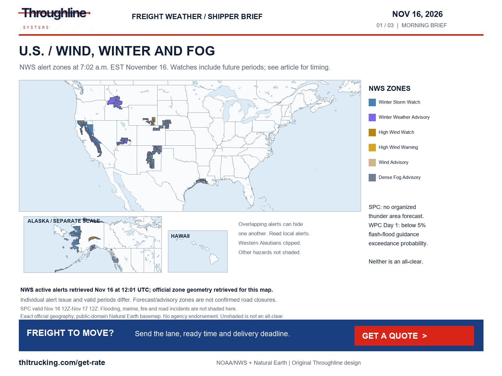
Sources: Caltrans I-80 road conditions; SPC Day 1 convective outlook; NWS national active alerts; WPC excessive rainfall discussion
Diesel: November 9 remains the latest weekly observation
The retrieved EIA update lists U.S. on-highway diesel at $6.127 per gallon, including taxes, for November 9, 2026. That is down $0.165 from $6.292 on November 2. No November 16 observation was present in the morning retrieval; these are weekly pump-price observations, not a daily freight-rate series.
Use the dated figure when checking a fuel-surcharge calculation, and confirm the benchmark week and formula specified in your agreement. A lower national diesel observation does not establish a lower all-in quote for a particular lane: equipment, shipment dimensions, appointments and the carrier’s actual operating requirements still matter.
Sierra I-80: chain controls and screening are confirmed
At 4:02 a.m. PST November 16, Caltrans reports chains required eastbound from Kingvale to the Donner Lake Interchange and westbound from Truckee to 4.7 miles west of Kingvale. The posted exception is for four-wheel-drive vehicles with snow tires on all four wheels. Do not assume that exception applies to the truck moving your shipment; the carrier must confirm applicable requirements.
Eastbound trucks are being screened at Applegate in Placer County. Westbound trucks are being screened at Mogul, five miles west of Reno in Washoe County. In both directions, Caltrans says drivers must possess maximum chains to proceed and permit loads are prohibited. These screening and permit restrictions are separate from the chain-control segments.
The NWS Sacramento advisory issued November 15 at 11:40 a.m. PST remains valid from November 15 at 4 p.m. through November 16 at 10 p.m. PST. Above 6,000 feet in the named northern Sierra and southern Cascades zones, it forecasts total snow of 2–8 inches, up to 16 inches near Lassen Volcanic National Park, with gusts up to 40 mph. Those totals cover the advisory period, not a uniform road-level accumulation.
For a Monday delivery, confirm the carrier’s current restriction check before promising the receiver an arrival. For open-deck freight, include the actual dimensions and any permit requirements in that conversation. A chain-control report does not by itself tell you the shipment’s delay duration.
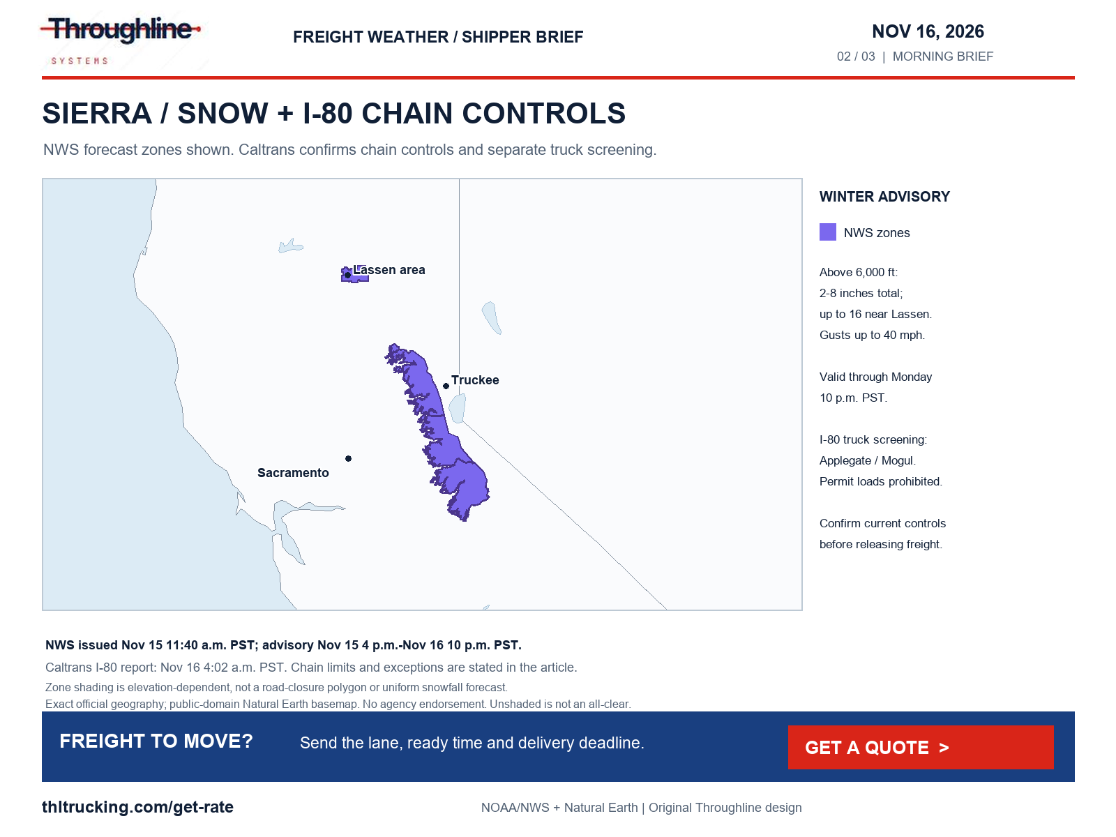
Sources: Caltrans I-80 road conditions; NWS national active alerts
Next snow window: western passes and the northern Rockies
WPC’s November 16 2:27 a.m. EST winter discussion covers November 16 12:00 UTC through November 19 12:00 UTC. It identifies mountain snow from the Sierra and Great Basin toward Idaho, Utah, western Wyoming and western Montana as the system progresses. This is a multi-day forecast, not confirmation that every highway in those states is restricted.
A separate NWS Greater Lake Tahoe advisory issued November 16 at 2:05 a.m. PST runs until 7 p.m. PST Monday. It calls for additional snow of 3–8 inches above 7,000 feet, highest west of Highway 89, and up to 2 inches around lake level, with ridgetop gusts as high as 70 mph. The same bulletin’s much larger snow totals concern a later winter storm watch from late Tuesday night through late Thursday night; do not combine those periods.
Farther inland, NWS Northwest Beaverhead County’s advisory issued at 4:49 a.m. MST Monday forecasts 2–5 inches total from 11 p.m. Monday to 11 p.m. Tuesday MST. Southern Utah mountain advisories also begin Monday night. For freight crossing these areas, ask for a fresh pass and state DOT check near departure and again before the affected segment. Preserve flexibility in Tuesday receiving appointments where feasible.
Sources: WPC heavy snow and icing discussion; NWS national active alerts
Wind: Gulf Coast advisories now, Wyoming watch later
NWS’s 5:47 a.m. CST November 16 advisory for the Matagorda and Brazoria islands, Galveston Island and Bolivar Peninsula runs through noon CST Monday: northeast winds 20–30 mph, gusting to 35 mph. A separate 11:06 p.m. CST Sunday advisory for portions of southeast Texas and southwest/south-central Louisiana also runs through noon Monday, with northeast winds around 20 mph and gusts to 30 mph.
These advisories warrant a check of exposed loading, loose packaging and outdoor staging. They are not truck prohibitions. Separately, Caltrans’ 4:02 a.m. PST report carries a Bay Bridge high-wind advisory stating travel is not recommended for campers, trailers or permit loads; preserve that advisory wording rather than calling the bridge closed.
For Wyoming, NWS watches issued at 1:28 a.m. MST Monday cover the later Tuesday-night–Wednesday window. The North Snowy Range Foothills, including Arlington and Elk Mountain along I-80, have possible southwest winds of 35–45 mph with gusts to 70 mph. Other watched areas include the I-80 summit between Cheyenne and Laramie and the Bordeaux I-25 area, with gusts to 65 mph possible. These are watches, not confirmed WYDOT high-profile restrictions. Use the current WYDOT report before deciding whether the planned truck can proceed.
Sources: NWS national active alerts; Caltrans I-80 road conditions; WYDOT I-80 current road report
Visibility, ice and Alaska: hazards beyond heavy rain
NWS New Mexico fog advisories issued November 16 at 4:21 a.m. MST run through 9 a.m. MST. The Santa Fe metro advisory specifies visibility of a quarter mile or less; a separate advisory across named central and eastern zones includes freezing fog and possible light ice on exposed surfaces. Confirm origin-yard and receiver access, not just the interstate status.
Colorado’s 4:07 a.m. MST advisory covers Greeley, Fort Morgan and Sterling through 10 a.m. MST, with visibility below one mile and fog noted along I-76. Western Nebraska’s advisory, issued Sunday at 7:39 p.m. CST, runs through Monday 11 a.m. CST/10 a.m. MST and forecasts quarter-mile-or-less visibility in its named counties. These are visibility advisories, not verified highway closures.
Alaska also has material hazards. NWS’s 2:59 a.m. AKST Monday advisory for Interior Kenai, Skilak Lake and Turnagain Pass continues through 1 p.m. AKST with mixed precipitation, 5–10 inches total snow, up to 12 inches through Turnagain Pass and a light glaze of ice. A separate Southern Kenai Mountains advisory reports freezing rain occurring through 7 a.m. AKST. Confirm local access with the responsible transport authority before arranging an Alaska pickup.
The Atka and Adak high-wind warning issued Sunday at 12:40 p.m. AKST is valid Monday 6 p.m.–Tuesday 6 a.m. AKST, forecasting southwest winds 45–60 mph and gusts as high as 80 mph. Pribilof Islands have a separate Tuesday 3–9 a.m. AKST warning. These island hazards matter for local handling and connections; they do not establish a mainland U.S. trucking disruption.
Sources: NWS national active alerts
Severe weather and flooding: today differs from Tuesday
SPC’s Day 1 outlook issued Sunday at 11:27 p.m. CST, valid Monday 12:00 UTC–Tuesday 12:00 UTC, draws no organized thunderstorm area. It still discusses sparse, short-lived lightning potential in parts of the Pacific Coast and Great Basin. This is a scoped convective forecast, not a guarantee against every severe or road hazard.
WPC’s 3:51 a.m. EST Monday discussion places the Day 1 probability of rainfall exceeding flash-flood guidance below 5%. Existing local flood warnings or blocked drainage can still matter. Day 2, valid Tuesday 12:00 UTC–Wednesday 12:00 UTC, has a Slight excessive-rainfall risk along Florida’s Atlantic coast, extending north toward the Georgia border.
Existing river flooding is separate from that forecast: the NWS warning issued November 15 at 7:41 p.m. EST reports major flooding on the St. Johns River near Cocoa 9w in Brevard County, Florida, until further notice. The reported stage was 17.1 feet at 7:15 p.m. Sunday. Other St. Johns warnings cover the area above Lake Harney and Astor. Confirm site-specific access with the receiver and local authority; a warning’s threshold-based impact examples are not proof that every named road is currently closed.
For Tuesday Florida deliveries, confirm who can verify the receiver’s driveway and unloading area, whether outdoor loading can pause, and how an appointment change will be communicated. The forecast supports preparation; it does not confirm a flooded terminal, a specific road closure or a fixed transit delay.
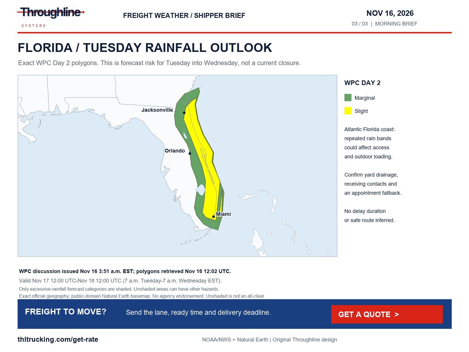
Sources: SPC Day 1 convective outlook; WPC excessive rainfall discussion; NWS national active alerts
Independent road incidents: crash, fire and construction
The same 4:02 a.m. PST Caltrans report lists westbound I-80 closed at Powell Street in Emeryville, Alameda County, because of a collision. This Bay Area closure is separate from the Sierra chain controls. A carrier serving the East Bay should obtain a current status before the pickup or delivery approach.
MDOT’s feed retrieved at 7:01 a.m. EST reports both directions of Old US 27 between Sheridan Road and Coleman Road in Clinton County closed because of a fire, reported at 6:17 a.m. The feed also lists an eastbound I-94 crash after Sprinkle Road Exit 80 in Kalamazoo County, reported 6:29 a.m., as impacting traffic; it does not label that entry a full closure.
Caltrans’ 4:02 a.m. PST SR 47 report continues to list the Harbor Boulevard–Ferry Street segment in Los Angeles County closed for construction, with its posted end time of 6 a.m. February 29, 2028. Use the exact segment when checking port-area access; this is not a claim that every port entrance or every part of SR 47 is closed.
For any affected shipment, the useful handoff is the precise road or entrance, the agency’s timestamp, the carrier’s next check and the receiver’s change contact. Do not turn an incident listing into an unsupported estimate of hours lost.
Sources: Caltrans I-80 road conditions; MDOT Mi Drive incidents; Caltrans SR 47 road conditions
Port activity: strong October volume is context, not a delay report
The latest release found on the Port of Los Angeles news index is dated November 12. It reports 1,026,872 twenty-foot equivalent units handled in October 2026, a record October and the second consecutive month above one million TEUs. Loaded imports were approximately 538,620 TEUs; loaded exports were 114,981 TEUs.
For distributors planning replenishment or manufacturers receiving imported inputs, the practical action is to connect container availability with the downstream truck appointment, inventory need and unloading capacity. Monthly throughput describes activity already handled. It does not prove a present terminal queue, rail delay or nationwide capacity shortage.
Before committing the onward FTL or partial shipment, verify that freight is released and physically available, identify the actual pickup facility and provide accurate piece dimensions and loading method. Use a dedicated expedited option only after checking the shipment’s fit and the facility’s ability to load and receive it.
Before releasing Monday freight
Use one shipment reference across the shipper, carrier and receiver so a changed restriction or appointment does not create conflicting instructions.
- Confirm the ready time, actual piece count, packaged dimensions and gross weight.
- For open-deck loads, state weather protection, loading equipment and any permit needs.
- For enclosed or expedited freight, confirm door clearance and handling equipment rather than relying on a vehicle label.
- Separate a requested arrival from an appointment the receiver has accepted.
- Record the current official restriction check, the carrier’s next update time and the person authorized to change the appointment.
Sources:
Coverage and limits
This review screened high winds and gusts; severe thunderstorms, damaging wind, hail and tornado potential; snowfall, blowing snow, blizzard and freezing precipitation; flooding; fog, smoke, dust and other visibility hazards; and independent crashes, fire, construction, damage and transport restrictions. The evidence includes national NWS alerts, SPC convective/fire outlooks, WPC rain/winter products and selected DOT/511 reports.
SPC’s 12:52 a.m. CST Monday fire outlook has no critical areas for Monday 12:00 UTC–Tuesday 12:00 UTC. No smoke or dust alert category appeared in the retrieved national alert set. Neither finding rules out a local fire, smoke pocket or closure; MDOT’s fire closure above is independent evidence.
The state-source scan is not a complete national incident inventory. Some 511 pages expose only JavaScript shells; Washington retrievals had certificate errors and a rail-source request failed. Where current incident detail was unavailable, no all-clear was inferred. Original maps use official factual geography and public-domain Natural Earth boundaries with the approved Throughline wordmark; overlapping alert zones and clipped western Aleutians limit the national overview.
Additional river warnings reviewed include the Skokomish at Potlatch in Mason County, Washington; the Nueces near Tilden, Texas; and dam-release flooding along the Gila in Maricopa and northeastern Yuma counties, Arizona. These are local river hazards, not verified interstate closures. Check low-water approaches and receiving-yard access where relevant.
Sources: NWS national active alerts; SPC Day 1 fire weather outlook; SPC Day 1 convective outlook; WPC excessive rainfall discussion; WPC heavy snow and icing discussion
Sources and editorial notes
Original analysis by Throughline Systems. Source links may show newer releases after this article’s publication; the observation and issue dates below identify the material used. Agency citations do not imply endorsement.
- EIA weekly gasoline and diesel update
November 9, 2026 weekly observation; U.S. on-highway diesel, dollars per gallon including taxes; compared with November 2
Accessed .
- NWS national active alerts
Snapshot November 16 at 7:01 a.m. EST; individual issue and valid periods stated below
Accessed .
- SPC Day 1 convective outlook
Issued November 15 at 11:27 p.m. CST; valid November 16 12:00 UTC–November 17 12:00 UTC
Accessed .
- WPC excessive rainfall discussion
Issued November 16 at 3:51 a.m. EST; Day 1 November 16–17 and Day 2 November 17–18, each 12:00–12:00 UTC
Accessed .
- WPC heavy snow and icing discussion
Issued November 16 at 2:27 a.m. EST; valid November 16 12:00 UTC–November 19 12:00 UTC
Accessed .
- Caltrans I-80 road conditions
November 16 at 4:02 a.m. PST road report; California I-80 and Nevada approach screening
Accessed .
- Caltrans SR 47 road conditions
November 16 at 4:02 a.m. PST; Los Angeles County construction restriction
Accessed .
- MDOT Mi Drive incidents
Retrieved November 16 at 7:01 a.m. EST; incident-specific local reported times below
Accessed .
- WYDOT I-80 current road report
Retrieved November 16 at 7:02 a.m. EST; live report must be checked again near dispatch
Accessed .
- Port of Los Angeles October cargo release
Released November 12, 2026; October 2026 volume in twenty-foot equivalent units (TEUs)
Accessed .
- SPC Day 1 fire weather outlook
Issued November 16 at 12:52 a.m. CST; valid November 16 12:00 UTC–November 17 12:00 UTC
Accessed .