November 19 logistics briefing: Sierra truck closures, SoCal rain, Florida flood risk
Plan November 19 freight around Caltrans truck closures and chains on I-80 in the Sierra, Southern California rain and pass winds, and Florida flood watches.
By Throughline Systems · · 8 min read · Updated
What matters for your next load
- Before releasing Reno–Sacramento freight, have the carrier recheck Caltrans for the actual vehicle: its 3:23 a.m. report lists I-80 closed westbound to all tractor-semitrailer combinations at the Nevada State Line, with chains required over the summit.
- In Southern California, add buffer to Thursday appointments around Los Angeles, the Grapevine, Cajon Pass and San Gorgonio Pass, and ask about high-profile or empty trailers while NWS wind advisories run.
- For Florida receivers from Miami to Jacksonville, confirm yard access and unloading plans while flood watches are in effect; a flood watch is not a road closure.
- For I-80 in Utah and northern Nevada, ask carriers to check UDOT Traffic and NVRoads before dispatch; this review could not read either site's live condition lists.
What changed since the November 18 briefing
Sierra: Yesterday's briefing found no restrictions in the Northern California and Sierra section of the Caltrans I-80 report. Caltrans' I-80 report timestamped 03:23 AM today (no time zone labeled) now lists I-80 closed westbound to all tractor-semitrailer combinations at the Nevada State Line and closed eastbound at Applegate to single drive axle tractor-semitrailers towing double trailers, both due to spinouts, with chains required from 3.4 miles east of Gold Run to the Nevada State line. The NWS Winter Storm Warning still runs until Friday at 7:00 a.m. ET; the 36-hour NWS snow forecast for Donner Summit is now 14.5 inches, down from 30.0 inches in yesterday's snapshot.
Wyoming: Yesterday's top hot spot is not one today. Wyoming's I-80 summits are still rated medium on forecast gusts of 45 to 51 mph, but no active NWS wind alert is attached to them in this snapshot. This review did not recheck WYDOT, so it does not confirm that yesterday's vehicle-specific wind restrictions have ended.
Alerts issued since yesterday's snapshot put new places on the list: a Flood Watch for the Los Angeles area from 9:00 a.m. to 9:00 p.m. ET today, NWS wind advisories for the I-5 corridor, Cajon Pass and San Gorgonio Pass, a Winter Weather Advisory for the Wasatch including Parleys Summit from 1:00 p.m. ET today, winter weather advisories along I-80 in northern Nevada and around Reno, and a morning dense fog advisory around Amarillo. The flood watches for Orlando and Jacksonville keep the same end time, Friday at 7:00 p.m. ET, and a separate Flood Watch for Palm Beach and Broward counties runs until 7:00 p.m. ET today.
Sources: Caltrans I-80 road report; NWS Winter Storm Warning: Lassen Volcanic National Park; Sierra Nevada of Tehama-Butte-Plumas Counties Above 3000 ft and more; NWS point forecast: Donner Summit, CA; NWS Flood Watch: Santa Clarita Valley; Malibu Coast; Los Angeles County Beaches; Palos Verdes Hills and more; NWS Wind Advisory: Interstate 5 Corridor; Western San Gabriel Mountains and Highway 14 Corridor; Eastern San Gabriel Mountains; NWS Winter Weather Advisory: Wasatch Mountains I-80 North; Wasatch Mountains South of I-80; Western Uinta Mountains; NWS Winter Weather Advisory: Humboldt County; Northern Elko County; White Pine County; Northern Lander County and Northern Eureka County and more; NWS Winter Weather Advisory: Greater Reno-Carson City-Minden Area; NWS Dense Fog Advisory: Hansford; Ochiltree; Hutchinson; Roberts; Oldham; Potter; Carson; Gray; Deaf Smith; Randall; Armstrong and more; NWS Flood Watch: Inland Volusia; Orange; Seminole; Osceola; Okeechobee; Coastal Volusia; Coastal Indian River and more; NWS Flood Watch: Inland Palm Beach County; Metro Palm Beach County; Inland Broward County; Metro Broward County and more
The three freight weather maps
Drawn from official NWS alerts, NWS gridded forecasts and SPC/WPC outlooks as of Nov 19, 6:15 AM ET. Shaded areas are active watches, warnings and advisories; markers are freight hubs and mountain passes rated for the next 36 hours. Forecast risk is not a road closure: closures appear only in the hot spots below, and only when a state DOT or 511 site lists them.
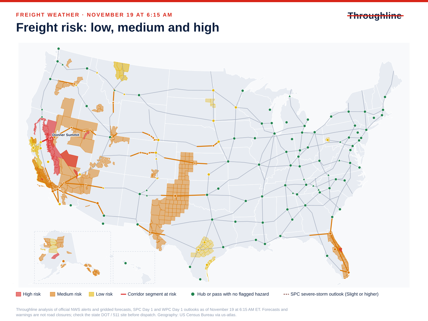
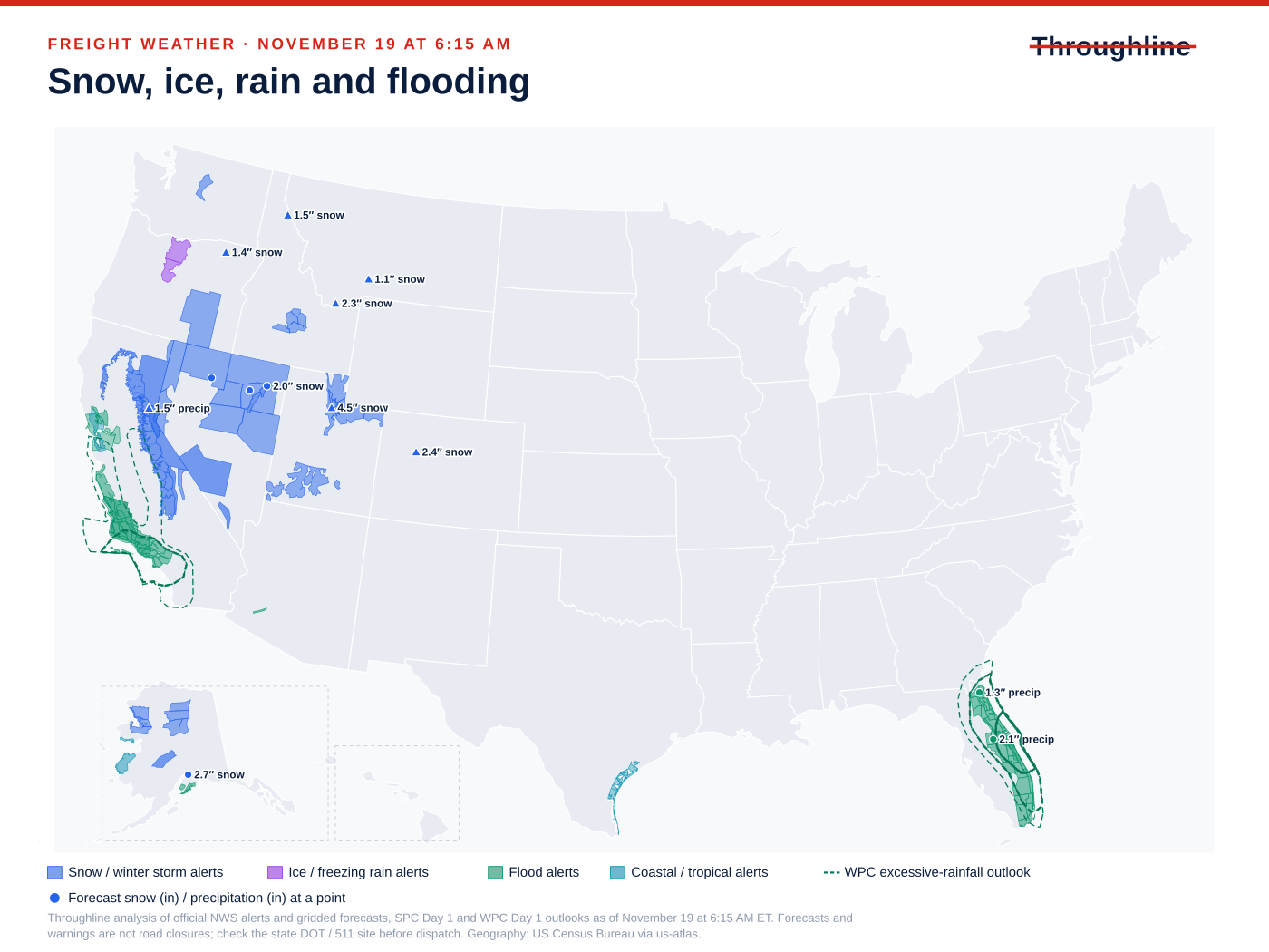
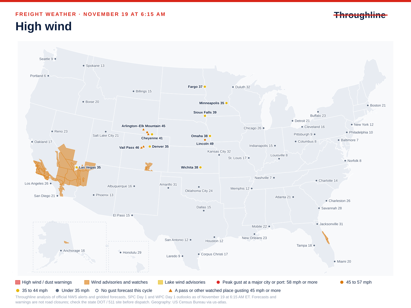
Sources: NWS national active-alert snapshot; SPC Day 1 convective outlook; WPC excessive rainfall outlook; WPC Winter Storm Severity Index
Sierra snow: Caltrans truck closures and chain controls on I-80
High risk · CA, NV · I-80. What the official forecasts and warnings say:
Donner Summit, CA: Winter Storm Warning until Fri 7:00 AM ET; 14.5 in of snow forecast in the next 36 h; WPC winter storm severity: major impacts.
Reno, NV: Winter Weather Advisory until Thu 10:00 PM ET; 0.8 in of snow forecast in the next 36 h.
Road restrictions confirmed on the official state DOT / 511 site at the time shown. A weather warning alone is not listed here.
NVRoads (NV) could not be read at Nov 19, 6:24 AM ET; check it directly before dispatch.
- Do not release a tractor-trailer from Reno toward Sacramento on the assumption that I-80 is open: Caltrans lists tractor-semitrailer combinations closed westbound at the Nevada State Line. Have the carrier recheck Caltrans for the actual vehicle before dispatch.
- Eastbound doubles face a separate Caltrans closure at Applegate for single drive axle tractor-semitrailers towing double trailers; confirm the equipment type with the carrier before booking the move.
- Give Sacramento-area and Reno receivers a revised arrival window and agree who can move the appointment if the truck holds for the storm, which NWS warns runs until Friday morning.
| Route and location | Status | Official report |
|---|---|---|
| I-80, Nevada State Line, westbound (CA) | Restricted (e.g. high-profile or light vehicles): Caltrans lists I-80 closed westbound to all tractor-semitrailer combinations at the Nevada State Line due to spinouts; those combinations are advised to use an alternate route. This is not listed as a closure to all traffic. | Caltrans, Thursday, November 19th, 2026 at 03:23 AM as displayed; page does not label its time zone; retrieved Nov 19, 6:21 AM ET |
| I-80, Applegate (Placer Co), eastbound (CA) | Restricted (e.g. high-profile or light vehicles): Caltrans lists I-80 closed to eastbound single drive axle tractor-semitrailers towing double trailers at Applegate due to spinouts; those vehicles are advised to use an alternate route. | Caltrans, Thursday, November 19th, 2026 at 03:23 AM as displayed; page does not label its time zone; retrieved Nov 19, 6:21 AM ET |
| I-80, 3.4 mi east of Gold Run (Placer Co) to the Nevada State line (CA) | Chain control / traction law: Chains are required on all vehicles except 4-wheel-drive vehicles with snow tires on all 4 wheels. | Caltrans, Thursday, November 19th, 2026 at 03:23 AM as displayed; page does not label its time zone; retrieved Nov 19, 6:21 AM ET |
Sources: NWS Winter Storm Warning: Lassen Volcanic National Park; Sierra Nevada of Tehama-Butte-Plumas Counties Above 3000 ft and more; NWS point forecast: Donner Summit, CA; WPC Winter Storm Severity Index; NWS Winter Weather Advisory: Greater Reno-Carson City-Minden Area; NWS point forecast: Reno, NV; Caltrans: I-80, Nevada State Line, westbound; Caltrans: I-80, Applegate (Placer Co), eastbound; Caltrans: I-80, 3.4 mi east of Gold Run (Placer Co) to the Nevada State line
Central and northeast Florida rain: flood watches through Friday evening
Medium risk · FL · I-10, I-95. What the official forecasts and warnings say:
Orlando, FL: Flood Watch until Fri 7:00 PM ET; 2.1 in of precipitation forecast in the next 36 h; WPC excessive rainfall: Slight (At Least 15%).
Jacksonville, FL: Flood Watch until Fri 7:00 PM ET; WPC excessive rainfall: Slight (At Least 15%); 1.3 in of precipitation forecast in the next 36 h.
FL511 (FL) could not be read at Nov 19, 6:26 AM ET; check it directly before dispatch.
- Confirm receiver yard drainage, dock access and unloading arrangements in the Orlando and Jacksonville areas before the truck arrives.
- Protect moisture-sensitive freight: confirm enclosed equipment or agreed tarping, and that pallets will not sit in standing water at the dock.
- Agree who can revise the appointment if rain affects access; a flood watch is not a highway closure.
Sources: NWS Flood Watch: Inland Volusia; Orange; Seminole; Osceola; Okeechobee; Coastal Volusia; Coastal Indian River and more; NWS point forecast: Orlando, FL; WPC excessive rainfall outlook; NWS Flood Watch: Inland Flagler; Coastal Duval; Eastern Clay; Eastern Putnam; Coastal Flagler; Trout River; Western Clay and more; NWS point forecast: Jacksonville, FL
South Florida rain: Flood Watch through this evening
Medium risk · FL · I-75, I-95. What the official forecasts and warnings say:
Miami, FL: Flood Watch until Thu 7:00 PM ET; WPC excessive rainfall: Slight (At Least 15%).
FL511 (FL) could not be read at Nov 19, 6:26 AM ET; check it directly before dispatch.
- Ask South Florida receivers whether yard flooding would change dock assignments or unloading times today.
- Keep afternoon appointments flexible until the watch ends at 7:00 p.m. ET; a flood watch is not a road closure.
Sources: NWS Flood Watch: Inland Palm Beach County; Metro Palm Beach County; Inland Broward County; Metro Broward County and more; WPC excessive rainfall outlook
Southern California: Los Angeles flood watch and wind on the Grapevine, Cajon and San Gorgonio passes
Medium risk · CA · I-5, I-10, I-15. What the official forecasts and warnings say:
Los Angeles–Long Beach, CA: Flood Watch Thu 9:00 AM – Thu 9:00 PM ET; WPC excessive rainfall: Slight (At Least 15%).
Tejon Pass (the Grapevine), CA: Wind Advisory Thu 7:00 AM – Thu 12:00 PM ET; Flood Watch Thu 9:00 AM – Thu 9:00 PM ET; WPC excessive rainfall: Marginal (At Least 5%).
Cajon Pass, CA: Wind Advisory until Thu 7:00 PM ET; WPC excessive rainfall: Slight (At Least 15%); Gusts to 40 mph forecast.
Inland Empire (Ontario), CA: WPC excessive rainfall: Slight (At Least 15%).
San Gorgonio Pass, CA: Wind Advisory until Thu 7:00 PM ET; WPC excessive rainfall: Marginal (At Least 5%).
San Diego–Otay Mesa, CA: WPC excessive rainfall: Marginal (At Least 5%).
San Diego, CA: WPC excessive rainfall: Marginal (At Least 5%).
Road restrictions confirmed on the official state DOT / 511 site at the time shown. A weather warning alone is not listed here.
- Ask carriers about high-profile and empty trailers on I-5 through the Grapevine, I-15 over Cajon Pass and I-10 through San Gorgonio Pass while NWS wind advisories are in effect.
- Confirm warehouse and terminal receiving plans in Los Angeles–Long Beach and the Inland Empire for today's rain; a flood watch is not a terminal or road closure.
- For night moves around Ontario, Santa Clarita and Irvine, check the Caltrans connector closures listed for this hot spot before setting appointment times.
| Route and location | Status | Official report |
|---|---|---|
| I-10, Eastbound connector to northbound I-15, Ontario (San Bernardino Co) (CA) | Closed: Construction closure of the connector ramp only, from 2100 hrs each night to 0600 hrs each morning through 11/20/26; motorists are advised to use an alternate route. Not weather-related. | Caltrans, Thursday, November 19th, 2026 at 03:23 AM as displayed; page does not label its time zone; retrieved Nov 19, 6:22 AM ET |
| I-10, Tippecanoe Ave, San Bernardino (San Bernardino Co), westbound (CA) | Lane closure: Westbound traffic is reduced to 1 lane, 24 hours a day, 7 days a week, due to emergency work. Not weather-related. | Caltrans, Thursday, November 19th, 2026 at 03:23 AM as displayed; page does not label its time zone; retrieved Nov 19, 6:22 AM ET |
| I-5, Southbound connector to northbound SR 14 (Los Angeles Co) (CA) | Closed: Construction closure of the connector ramp only, from 2100 hrs each night to 0500 hrs each morning, Monday thru Friday thru 11/20/26; motorists are advised to use an alternate route. Not weather-related. | Caltrans, Thursday, November 19th, 2026 at 03:24 AM as displayed; page does not label its time zone; retrieved Nov 19, 6:23 AM ET |
| I-5, Northbound connector to northbound SR 133, Irvine (Orange Co) (CA) | Closed: Construction closure of the connector ramp only, from 2100 hrs each night to 0500 hrs each morning, Tuesday thru Saturday thru 11/21/26; motorists are advised to use an alternate route. Not weather-related. | Caltrans, Thursday, November 19th, 2026 at 03:24 AM as displayed; page does not label its time zone; retrieved Nov 19, 6:23 AM ET |
Sources: NWS Flood Watch: Santa Clarita Valley; Malibu Coast; Los Angeles County Beaches; Palos Verdes Hills and more; WPC excessive rainfall outlook; NWS Wind Advisory: Interstate 5 Corridor; Western San Gabriel Mountains and Highway 14 Corridor; Eastern San Gabriel Mountains; NWS Wind Advisory: San Bernardino County Mountains; NWS point forecast: Cajon Pass, CA; NWS Wind Advisory: San Gorgonio Pass Near Banning; Caltrans: I-10, Eastbound connector to northbound I-15, Ontario (San Bernardino Co); Caltrans: I-10, Tippecanoe Ave, San Bernardino (San Bernardino Co), westbound; Caltrans: I-5, Southbound connector to northbound SR 14 (Los Angeles Co); Caltrans: I-5, Northbound connector to northbound SR 133, Irvine (Orange Co)
Wasatch snow: Parleys Summit on I-80 from this afternoon
Medium risk · UT · I-80. What the official forecasts and warnings say:
Parleys Summit, UT: Winter Weather Advisory Thu 1:00 PM – Sat 1:00 PM ET; 4.5 in of snow forecast in the next 36 h.
UDOT Traffic (UT) could not be read at Nov 19, 6:26 AM ET; check it directly before dispatch.
- Where receivers allow, move Salt Lake City–Park City and eastbound I-80 pickups ahead of the advisory start at 1:00 p.m. ET.
- Ask the carrier to check UDOT Traffic for traction or chain restrictions before dispatch; this review could not read UDOT's live lists.
Sources: NWS Winter Weather Advisory: Wasatch Mountains I-80 North; Wasatch Mountains South of I-80; Western Uinta Mountains; NWS point forecast: Parleys Summit, UT
Northern Nevada snow: I-80 at Winnemucca, Elko and Wells
Medium risk · NV · I-80. What the official forecasts and warnings say:
Wells, NV: Winter Weather Advisory until Fri 7:00 PM ET; 2.0 in of snow forecast in the next 36 h.
Winnemucca, NV: Winter Weather Advisory until Fri 7:00 PM ET; 1.0 in of snow forecast in the next 36 h.
Elko, NV: Winter Weather Advisory until Fri 7:00 PM ET; 1.6 in of snow forecast in the next 36 h.
NVRoads (NV) could not be read at Nov 19, 6:24 AM ET; check it directly before dispatch.
- Build extra time into I-80 transits across northern Nevada while the advisory runs until Friday at 7:00 p.m. ET.
- Ask the carrier to check NVRoads for chain controls before dispatch; this review could not read NVRoads' live condition lists.
Sources: NWS Winter Weather Advisory: Humboldt County; Northern Elko County; White Pine County; Northern Lander County and Northern Eureka County and more; NWS point forecast: Wells, NV; NWS point forecast: Winnemucca, NV; NWS point forecast: Elko, NV
Texas Panhandle: dense fog on I-40 around Amarillo this morning
Medium risk · TX · I-40. What the official forecasts and warnings say:
Amarillo, TX: Dense Fog Advisory until Thu 11:00 AM ET.
DriveTexas (TX) could not be read at Nov 19, 6:26 AM ET; check it directly before dispatch.
- Expect slower early-morning movement on I-40 around Amarillo, and confirm late-morning arrival windows with receivers until the advisory ends at 11:00 a.m. ET.
- Ask the carrier to check DriveTexas before dispatch; this review could not retrieve it.
Morning freight picture: Sierra snow, West Coast rain and Florida flood watches
This review uses official data retrieved November 19 at 6:15 a.m. ET; point forecasts cover the next 36 hours, and each alert keeps its own issue and valid times. Of 272 freight places rated, 1 is high risk (Donner Summit on I-80) and 29 are medium risk. I-80 is the only interstate with a high-risk stretch; I-5, I-10, I-15, I-40, I-70, I-75, I-84 and I-95 have medium-risk stretches. Throughline risk ratings are planning analysis, not DOT permissions or delay forecasts.
Flooding (30 alerts), snow and winter storm (27), high wind (17) and fog, dust and visibility (15) lead the national alert counts. WPC's Day 1 excessive rainfall outlook peaks at Moderate along Florida's east-central Atlantic coast, with Slight risk from Miami to Jacksonville and across coastal Southern California. WPC's Winter Storm Severity Index reaches Extreme in the central and southern Sierra Nevada and Major around the I-80 crossing. SPC's Day 1 outlook tops out at a Marginal severe risk in central California.
Outside the hot spots below, NWS wind advisories cover I-40 at Barstow and Kingman from 1:00 p.m. ET today to 3:00 a.m. ET Friday, and dense fog advisories run this morning at Van Horn on I-10 in Texas, Hays on I-70 in Kansas and Pendleton on I-84 in Oregon. Wyoming's I-80 summits, Lincoln, Neb., and Colorado's I-70 mountain passes are rated on forecast gusts alone.
Floods and other disasters: NWS Phoenix has a Flood Warning until Tuesday for Gila River flooding from Painted Rock Dam releases in Maricopa and northeastern Yuma counties, affecting farmland and low-water crossings. It is not a Phoenix-area interstate warning, so it is not a hot spot today. NHC lists no active tropical cyclones. FEMA's last 30 days include a major disaster declaration for Hurricane Isaias in Florida Panhandle counties (October 27) and an emergency declaration for severe storms and flooding in parts of New Mexico (October 26); these are recovery declarations, not road closures.
Sources: NWS national active-alert snapshot; WPC excessive rainfall outlook; WPC Winter Storm Severity Index; SPC Day 1 convective outlook; NWS Flood Warning: Maricopa, AZ; Yuma, AZ; NHC active tropical cyclones; FEMA DR-4955: Florida Hurricane Isaias major disaster declaration; FEMA EM-3660: New Mexico severe storms and flooding emergency declaration
Coverage and limits of this morning's review
Loaded: NWS active alerts, NWS gridded point forecasts (272 of 272 grid cells), the NWS watches, warnings and advisories map service, SPC Day 1, WPC Day 1 excessive rainfall and Winter Storm Severity Index, NHC active storms and OpenFEMA declarations. Not loaded: the automated EIA weekly diesel feed, which had no API credential in this run, so this edition has no diesel section.
Road checks: Caltrans route reports for I-80 and I-10 (03:23 AM) and I-5 (03:24 AM), as displayed with no time zone labeled, were read; their restrictions are listed in the hot spots. NVRoads' road-conditions and events lists, UDOT Traffic's road-conditions and road-restrictions pages, and FL511's events list returned only an app shell, and DriveTexas refused automated retrieval, so road status in Nevada, Utah, Florida and Texas is unverified here. FL511's separate alerts page showed wet-road caution advisories for Broward and Palm Beach counties, last updated November 18, and no closures. NVRoads' advisories page displayed no advisories; that is not a road-condition report.
Caltrans also lists advisories that are not restrictions: a dense fog advisory on I-5 from the Los Angeles/Kern county line to 5 miles south of the SR 99 junction at Grapevine Road, and high wind advisories on I-80 at the San Francisco–Oakland Bay Bridge and between the Solano/Yolo and Yolo/Sacramento county lines, where travel is not recommended for campers, trailers or permit loads. No alternate truck route or delay duration is certified here, and unshaded areas or unlisted roads are not an all-clear.
Sources: NWS national active-alert snapshot; Caltrans I-80 road report; Caltrans I-5 road report; Caltrans I-10 road report
Sources and editorial notes
Original analysis by Throughline Systems. Source links may show newer releases after this article’s publication; the observation and issue dates below identify the material used. Agency citations do not imply endorsement.
- NWS national active-alert snapshot
National snapshot retrieved November 19 at 6:15 AM ET; each alert has its own issue and valid times
Accessed .
- SPC Day 1 convective outlook
Retrieved November 19 at 6:15 AM ET; highest category nationally: MRGL
Accessed .
- WPC excessive rainfall outlook
Day 1 outlook retrieved November 19 at 6:15 AM ET; highest category: Moderate (At Least 40%)
Accessed .
- WPC Winter Storm Severity Index
Day 1 retrieved November 19 at 6:15 AM ET; highest impact: EXTREME
Accessed .
- NWS Winter Storm Warning: Lassen Volcanic National Park; Sierra Nevada of Tehama-Butte-Plumas Counties Above 3000 ft and more
Issued 2026-11-18T11:13:00-08:00; valid until 2026-11-20T04:00:00-08:00
Accessed .
- NWS point forecast: Donner Summit, CA
Gridded forecast retrieved November 19 at 6:15 AM ET, next 36 hours
Accessed .
- NWS Winter Weather Advisory: Greater Reno-Carson City-Minden Area
Issued 2026-11-19T01:40:00-08:00; valid until 2026-11-19T19:00:00-08:00
Accessed .
- NWS point forecast: Reno, NV
Gridded forecast retrieved November 19 at 6:15 AM ET, next 36 hours
Accessed .
- NWS Flood Watch: Inland Volusia; Orange; Seminole; Osceola; Okeechobee; Coastal Volusia; Coastal Indian River and more
Issued 2026-11-16T15:18:00-05:00; valid until 2026-11-20T19:00:00-05:00
Accessed .
- NWS point forecast: Orlando, FL
Gridded forecast retrieved November 19 at 6:15 AM ET, next 36 hours
Accessed .
- NWS Flood Watch: Inland Flagler; Coastal Duval; Eastern Clay; Eastern Putnam; Coastal Flagler; Trout River; Western Clay and more
Issued 2026-11-19T01:13:00-05:00; valid until 2026-11-20T19:00:00-05:00
Accessed .
- NWS point forecast: Jacksonville, FL
Gridded forecast retrieved November 19 at 6:15 AM ET, next 36 hours
Accessed .
- NWS Flood Watch: Inland Palm Beach County; Metro Palm Beach County; Inland Broward County; Metro Broward County and more
Issued 2026-11-19T02:51:00-05:00; valid until 2026-11-19T19:00:00-05:00
Accessed .
- NWS Flood Watch: Santa Clarita Valley; Malibu Coast; Los Angeles County Beaches; Palos Verdes Hills and more
Issued 2026-11-18T13:53:00-08:00; valid until 2026-11-19T18:00:00-08:00
Accessed .
- NWS Wind Advisory: Interstate 5 Corridor; Western San Gabriel Mountains and Highway 14 Corridor; Eastern San Gabriel Mountains
Issued 2026-11-19T01:09:00-08:00; valid until 2026-11-19T09:00:00-08:00
Accessed .
- NWS Wind Advisory: San Bernardino County Mountains
Issued 2026-11-18T22:06:00-08:00; valid until 2026-11-19T16:00:00-08:00
Accessed .
- NWS point forecast: Cajon Pass, CA
Gridded forecast retrieved November 19 at 6:15 AM ET, next 36 hours
Accessed .
- NWS Wind Advisory: San Gorgonio Pass Near Banning
Issued 2026-11-18T22:06:00-08:00; valid until 2026-11-19T16:00:00-08:00
Accessed .
- NWS Winter Weather Advisory: Wasatch Mountains I-80 North; Wasatch Mountains South of I-80; Western Uinta Mountains
Issued 2026-11-18T22:38:00-07:00; valid until 2026-11-21T11:00:00-07:00
Accessed .
- NWS point forecast: Parleys Summit, UT
Gridded forecast retrieved November 19 at 6:15 AM ET, next 36 hours
Accessed .
- NWS Winter Weather Advisory: Humboldt County; Northern Elko County; White Pine County; Northern Lander County and Northern Eureka County and more
Issued 2026-11-18T11:52:00-08:00; valid until 2026-11-20T16:00:00-08:00
Accessed .
- NWS point forecast: Wells, NV
Gridded forecast retrieved November 19 at 6:15 AM ET, next 36 hours
Accessed .
- NWS point forecast: Winnemucca, NV
Gridded forecast retrieved November 19 at 6:15 AM ET, next 36 hours
Accessed .
- NWS point forecast: Elko, NV
Gridded forecast retrieved November 19 at 6:15 AM ET, next 36 hours
Accessed .
- NWS Dense Fog Advisory: Hansford; Ochiltree; Hutchinson; Roberts; Oldham; Potter; Carson; Gray; Deaf Smith; Randall; Armstrong and more
Issued 2026-11-19T04:01:00-06:00; valid until 2026-11-19T10:00:00-06:00
Accessed .
- NWS Flood Warning: Maricopa, AZ; Yuma, AZ
Issued 2026-11-17T08:21:00-07:00; valid until 2026-11-24T11:00:00-07:00
Accessed .
- Caltrans I-80 road report
November 19, 2026 at 03:23 AM as displayed; page does not label its time zone.
Accessed .
- Caltrans I-10 road report
November 19, 2026 at 03:23 AM as displayed; page does not label its time zone.
Accessed .
- Caltrans I-5 road report
November 19, 2026 at 03:24 AM as displayed; page does not label its time zone.
Accessed .
- NHC active tropical cyclones
Retrieved November 19 at 6:15 AM ET; no active tropical cyclones listed
Accessed .
- FEMA DR-4955: Florida Hurricane Isaias major disaster declaration
Declared October 27, 2026; OpenFEMA retrieved November 19 at 6:15 AM ET
Accessed .
- FEMA EM-3660: New Mexico severe storms and flooding emergency declaration
Declared October 26, 2026; OpenFEMA retrieved November 19 at 6:15 AM ET
Accessed .
- Caltrans: I-80, Nevada State Line, westbound
Restricted (e.g. high-profile or light vehicles) as reported Thursday, November 19th, 2026 at 03:23 AM as displayed; page does not label its time zone
Accessed .
- Caltrans: I-80, Applegate (Placer Co), eastbound
Restricted (e.g. high-profile or light vehicles) as reported Thursday, November 19th, 2026 at 03:23 AM as displayed; page does not label its time zone
Accessed .
- Caltrans: I-80, 3.4 mi east of Gold Run (Placer Co) to the Nevada State line
Chain control / traction law as reported Thursday, November 19th, 2026 at 03:23 AM as displayed; page does not label its time zone
Accessed .
- Caltrans: I-10, Eastbound connector to northbound I-15, Ontario (San Bernardino Co)
Closed as reported Thursday, November 19th, 2026 at 03:23 AM as displayed; page does not label its time zone
Accessed .
- Caltrans: I-10, Tippecanoe Ave, San Bernardino (San Bernardino Co), westbound
Lane closure as reported Thursday, November 19th, 2026 at 03:23 AM as displayed; page does not label its time zone
Accessed .
- Caltrans: I-5, Southbound connector to northbound SR 14 (Los Angeles Co)
Closed as reported Thursday, November 19th, 2026 at 03:24 AM as displayed; page does not label its time zone
Accessed .
- Caltrans: I-5, Northbound connector to northbound SR 133, Irvine (Orange Co)
Closed as reported Thursday, November 19th, 2026 at 03:24 AM as displayed; page does not label its time zone
Accessed .