November 18 logistics briefing: Wyoming wind restrictions, Sierra snow and Florida rain
Plan November 18 freight around Wyoming wind restrictions, Sierra snow and Florida rainfall risk, with weekly diesel data and practical checks for shippers.
By Throughline Systems · · 8 min read
What matters for your next load
- Check the actual vehicle and current WYDOT segment restriction before releasing a Wyoming shipment; a load-weight figure alone does not establish eligibility.
- Keep Sierra weather warnings separate from current Caltrans controls, and agree who can revise receiving appointments if the carrier holds departure.
- For Florida receivers, confirm yard access and unloading arrangements ahead of repeated rainfall; forecast shading is not a closure.
- Use the November 16 EIA diesel observation for weekly comparisons, not as a same-day truckload quote.
What changed since the November 16 briefing
The latest prior dated briefing on this site is November 16. Its Sierra chain controls were a dated road snapshot. At 7:05 a.m. EST today, the Caltrans I-80 report lists no restrictions in its northern California/Sierra section, while the Bay Bridge section advises against travel by trailers and permit loads because of wind. That is advice, not a blanket closure. Missing controls do not establish when a restriction ended or guarantee a later departure.
The planning horizon now includes the midweek Sierra storm and repeated eastern Florida rainfall. WYDOT separately confirms vehicle-specific wind restrictions on named I-80 segments. Treat these as different decisions: weather readiness, permission for the actual vehicle to proceed, and receiver acceptance of an appointment.
Sources: Caltrans I-80 road report; WYDOT I-80 conditions; WPC short-range forecast
The three freight weather maps
Original national overview followed by Greater Lake Tahoe and Florida close-ups. These maps show selected official hazards, not road closures.
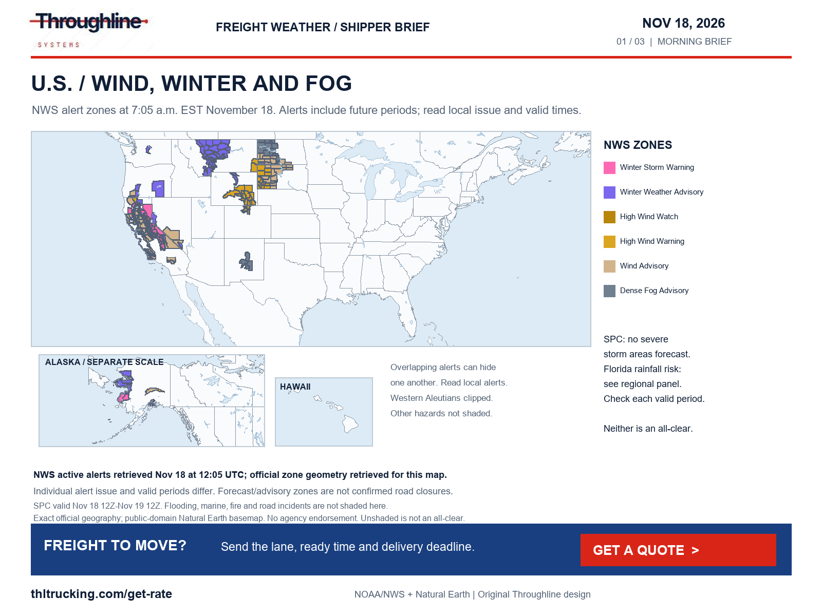
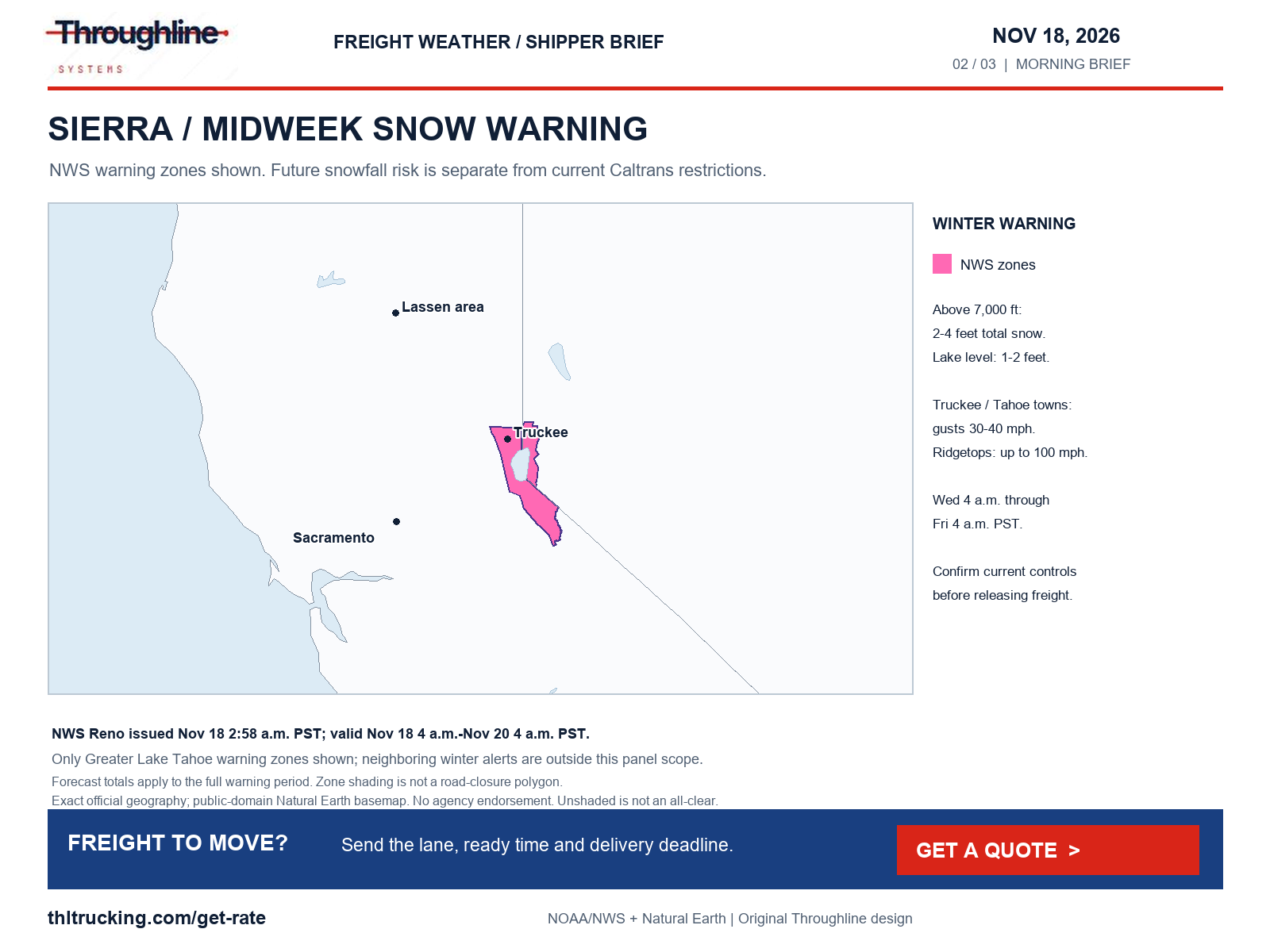
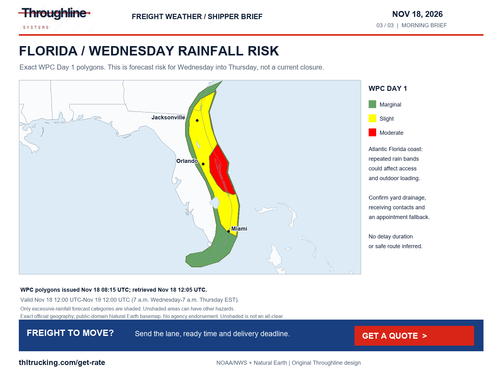
Sources: NWS national active-alert snapshot; SPC Day 1 convective outlook; WPC excessive rainfall outlook; WPC Winter Storm Severity Index
Wyoming wind and confirmed I-80 vehicle restrictions
High risk · WY · I-25, I-80. What the official forecasts and warnings say:
Cheyenne, WY: High Wind Warning until Wed 7:00 PM ET; Gusts to 59 mph forecast; Red Flag Warning Wed 11:00 AM – Wed 7:00 PM ET.
Arlington–Elk Mountain, WY: High Wind Warning until Wed 7:00 PM ET; Gusts to 69 mph forecast; WPC winter storm severity: minor impacts.
Sherman Summit, WY: High Wind Warning until Wed 7:00 PM ET; Gusts to 66 mph forecast.
Laramie, WY: High Wind Warning until Wed 7:00 PM ET; Gusts to 61 mph forecast.
Casper, WY: High Wind Warning until Wed 4:00 PM ET; Gusts to 56 mph forecast.
Rawlins, WY: Gusts to 54 mph forecast.
Road restrictions confirmed on the official state DOT / 511 site at the time shown. A weather warning alone is not listed here.
- Ask the carrier to recheck official road status for the actual vehicle before dispatch.
- Confirm receiver access and the next status-update time before treating an ETA as an appointment.
| Route and location | Status | Official report |
|---|---|---|
| I-80, Rawlins to exit 235, Walcott Junction (WY) | Restricted (e.g. high-profile or light vehicles): WYDOT lists a closure to high-profile vehicles under 50,000 GVW because of gusting winds. Other segments have separate thresholds; this is not a closure to all traffic. | WYDOT, November 18, 2026 03:27 AM as displayed; no time zone labeled in the table; retrieved Nov 18, 7:05 AM ET |
Sources: NWS High Wind Warning: Central Laramie County; NWS point forecast: Cheyenne, WY; NWS Red Flag Warning: Lower North Platte River Basin/Scottsbluff National Monument; Lodgepole Creek/Southern Nebraska Panhandle and more; NWS High Wind Warning: North Snowy Range Foothills; NWS point forecast: Arlington–Elk Mountain, WY; WPC Winter Storm Severity Index; NWS High Wind Warning: Shirley Basin; Laramie Valley; South Laramie Range; NWS point forecast: Sherman Summit, WY; NWS point forecast: Laramie, WY; NWS High Wind Warning: Natrona County Lower Elevations; Casper Mountain; NWS point forecast: Casper, WY; NWS point forecast: Sidney, NE; NWS point forecast: Monument Hill, CO; NWS point forecast: Rawlins, WY; NWS point forecast: Eisenhower–Johnson Tunnel, CO; WYDOT: I-80, Rawlins to exit 235, Walcott Junction
Sierra snow forecast: confirm current I-80 controls
High risk · CA · I-80. What the official forecasts and warnings say:
Donner Summit, CA: Winter Storm Warning until Fri 7:00 AM ET; 30.0 in of snow forecast in the next 36 h; 3.0 in of precipitation forecast in the next 36 h.
- Ask the carrier to recheck official road status for the actual vehicle before dispatch.
- Confirm receiver access and the next status-update time before treating an ETA as an appointment.
Sources: NWS Winter Storm Warning: Lassen Volcanic National Park; Sierra Nevada of Tehama-Butte-Plumas Counties Above 3000 ft and more; NWS point forecast: Donner Summit, CA; NWS Winter Weather Advisory: Greater Reno-Carson City-Minden Area
Flooding: Orlando, Jacksonville (FL)
Medium risk · FL · I-10, I-95. What the official forecasts and warnings say:
Orlando, FL: Flood Watch until Fri 7:00 PM ET; 2.0 in of precipitation forecast in the next 36 h; WPC excessive rainfall: Slight (At Least 15%).
Jacksonville, FL: Flood Watch until Fri 7:00 PM ET; WPC excessive rainfall: Slight (At Least 15%); 1.8 in of precipitation forecast in the next 36 h.
FL511 (FL) could not be read at Nov 18, 7:05 AM ET; check it directly before dispatch.
- Confirm the receiver’s yard access, drainage and unloading arrangements.
- Agree who can revise the appointment if rain affects access; do not infer a highway closure from forecast shading.
Sources: NWS Flood Watch: Inland Volusia; Orange; Seminole; Osceola; Okeechobee; Coastal Volusia; Coastal Indian River and more; NWS point forecast: Orlando, FL; WPC excessive rainfall outlook; NWS Flood Watch: Inland Flagler; Coastal Duval; Eastern Clay; Eastern Putnam; Coastal Flagler; Trout River; Western Clay and more; NWS point forecast: Jacksonville, FL
Morning freight picture: weather and access require separate checks
Research was retrieved November 18 at 7:05–7:07 a.m. EST. The point-forecast snapshot covers the next 36 hours from 7:06 a.m. EST; local warning validity can be shorter or longer. Throughline risk categories are planning analysis, not DOT permissions or measured delay forecasts.
WPC forecasts heavy mountain snow and reduced visibility in the interior West, with particular concern in the Sierra. Its short-range discussion maintains a Moderate excessive-rainfall risk for parts of Florida’s Space and Treasure coasts Wednesday. Forecast risk does not confirm an inundated yard or a closed highway.
National alerts and outlooks were checked for high wind, severe thunderstorms, tornadoes and hail, snow and blowing snow, blizzard conditions, freezing rain, sleet and ice, flooding, fog, smoke, dust and road-surface hazards. The regional focus below is selective; unshaded areas and unlisted roads are not an all-clear.
Sources: NWS national active-alert snapshot; SPC Day 1 convective outlook; WPC short-range forecast
Diesel: latest available week is November 16
EIA’s latest displayed U.S. on-highway diesel observation is $5.937 per gallon for November 16, including taxes. That compares with $6.127 for November 9, a decrease of $0.190 per gallon. These are weekly retail observations, not a daily price or a freight rate. EIA labels the diesel release November 17; retrieval was November 18 at 7:05 a.m. EST.
Among the five PADD regions, observations range from $5.547 in the Gulf Coast to $6.948 on the West Coast; California is $7.733. These geographic averages do not determine a carrier’s fuel purchase or a shipment-specific surcharge. When comparing offers, confirm whether fuel is included and which index week and formula apply.
A lower weekly diesel observation does not promise lower capacity pricing, faster transit or savings. Equipment, loading requirements, timing and the confirmed service scope still belong in the quote comparison.
Sources: EIA weekly on-highway diesel
Turn the conditions into a usable shipment handoff
For open-deck freight, confirm who can suspend exposed loading under the facility’s procedures and whether protection requirements are agreed before pickup. For enclosed equipment, confirm dock availability and the actual approach to the receiving yard. For an urgent sprinter shipment, verify usable dimensions, weight and receiving hours; urgency does not remove road restrictions.
- Name the person who checks current official road status before release.
- Send the carrier the actual equipment and shipment details; do not substitute cargo weight for the vehicle-specific restriction test.
- Give receiving an update time and a person authorized to accept a revised appointment.
- Keep a held departure, a revised ETA and a confirmed appointment as separate statuses.
Coverage, sources and limits
NWS alerts, gridded point forecasts and hazard-map data, SPC Day 1, WPC excessive-rainfall and winter-severity products, NHC and FEMA loaded for the snapshot. The automated EIA feed lacked an API credential; the weekly diesel section was verified separately against EIA’s public page.
The detailed road review covers selected WYDOT I-80 segments and Caltrans I-80. Florida 511 returned a page without usable incident detail, so Florida road access remains unverified here. Other retrieved state pages include app shells, and selected WSDOT pages failed certificate verification. No alternate truck route or delay duration is certified.
Independent non-weather incidents were reviewed as well: WYDOT lists bridge damage affecting the Higley Boulevard overpass at exit 214 near Rawlins; Caltrans lists a nightly Business 80 southbound connector closure to eastbound US 50 in Sacramento, 11 p.m.–5 a.m. Monday–Friday through November 20. These are specific structures and connectors, not closures of the entire interstate.
Official port and rail sources were also checked. BNSF pages could not be retrieved, and this review did not establish a new terminal-wide disruption suitable for publication. This evidence-based outlook does not manufacture a national logistics shutdown. Confirm terminal appointments directly when relevant.
Sources: NWS national active-alert snapshot; WYDOT I-80 conditions; Caltrans I-80 road report; EIA weekly on-highway diesel
Sources and editorial notes
Original analysis by Throughline Systems. Source links may show newer releases after this article’s publication; the observation and issue dates below identify the material used. Agency citations do not imply endorsement.
- NWS national active-alert snapshot
National snapshot retrieved November 18 at 7:06 AM ET; each alert has its own issue and valid times
Accessed .
- SPC Day 1 convective outlook
Retrieved November 18 at 7:06 AM ET; highest category nationally: TSTM
Accessed .
- WPC excessive rainfall outlook
Day 1 outlook retrieved November 18 at 7:06 AM ET; highest category: Moderate (At Least 40%)
Accessed .
- WPC Winter Storm Severity Index
Day 1 retrieved November 18 at 7:06 AM ET; highest impact: EXTREME
Accessed .
- NWS High Wind Warning: Central Laramie County
Issued 2026-11-18T01:10:00-07:00; valid until 2026-11-18T17:00:00-07:00
Accessed .
- NWS point forecast: Cheyenne, WY
Gridded forecast retrieved November 18 at 7:06 AM ET, next 36 hours
Accessed .
- NWS Red Flag Warning: Lower North Platte River Basin/Scottsbluff National Monument; Lodgepole Creek/Southern Nebraska Panhandle and more
Issued 2026-11-18T02:32:00-07:00; valid until 2026-11-18T17:00:00-07:00
Accessed .
- NWS High Wind Warning: North Snowy Range Foothills
Issued 2026-11-18T01:10:00-07:00; valid until 2026-11-18T17:00:00-07:00
Accessed .
- NWS point forecast: Arlington–Elk Mountain, WY
Gridded forecast retrieved November 18 at 7:06 AM ET, next 36 hours
Accessed .
- NWS High Wind Warning: Shirley Basin; Laramie Valley; South Laramie Range
Issued 2026-11-18T01:10:00-07:00; valid until 2026-11-18T17:00:00-07:00
Accessed .
- NWS point forecast: Sherman Summit, WY
Gridded forecast retrieved November 18 at 7:06 AM ET, next 36 hours
Accessed .
- NWS point forecast: Laramie, WY
Gridded forecast retrieved November 18 at 7:06 AM ET, next 36 hours
Accessed .
- NWS High Wind Warning: Natrona County Lower Elevations; Casper Mountain
Issued 2026-11-17T18:16:00-07:00; valid until 2026-11-18T14:00:00-07:00
Accessed .
- NWS point forecast: Casper, WY
Gridded forecast retrieved November 18 at 7:06 AM ET, next 36 hours
Accessed .
- NWS point forecast: Sidney, NE
Gridded forecast retrieved November 18 at 7:06 AM ET, next 36 hours
Accessed .
- NWS point forecast: Monument Hill, CO
Gridded forecast retrieved November 18 at 7:06 AM ET, next 36 hours
Accessed .
- NWS point forecast: Rawlins, WY
Gridded forecast retrieved November 18 at 7:06 AM ET, next 36 hours
Accessed .
- NWS point forecast: Eisenhower–Johnson Tunnel, CO
Gridded forecast retrieved November 18 at 7:06 AM ET, next 36 hours
Accessed .
- NWS Winter Storm Warning: Lassen Volcanic National Park; Sierra Nevada of Tehama-Butte-Plumas Counties Above 3000 ft and more
Issued 2026-11-18T01:16:00-08:00; valid until 2026-11-20T04:00:00-08:00
Accessed .
- NWS point forecast: Donner Summit, CA
Gridded forecast retrieved November 18 at 7:06 AM ET, next 36 hours
Accessed .
- NWS Winter Weather Advisory: Greater Reno-Carson City-Minden Area
Issued 2026-11-18T02:58:00-08:00; valid until 2026-11-19T19:00:00-08:00
Accessed .
- NWS Winter Storm Warning: South Central Siskiyou County
Issued 2026-11-18T03:02:00-08:00; valid until 2026-11-19T04:00:00-08:00
Accessed .
- NWS Winter Weather Advisory: South Central Siskiyou County
Issued 2026-11-18T03:02:00-08:00; valid until 2026-11-19T04:00:00-08:00
Accessed .
- NWS point forecast: Mount Shasta / Black Butte Summit, CA
Gridded forecast retrieved November 18 at 7:06 AM ET, next 36 hours
Accessed .
- NWS Winter Weather Advisory: South Central Oregon Cascades; Siskiyou Mountains and Southern Oregon Cascades
Issued 2026-11-18T03:02:00-08:00; valid until 2026-11-18T22:00:00-08:00
Accessed .
- NWS High Wind Warning: Northern Black Hills; Northern Foothills; Rapid City; Southern Foothills; Central Black Hills and more
Issued 2026-11-17T22:08:00-07:00; valid until 2026-11-18T09:00:00-07:00
Accessed .
- NWS point forecast: Rapid City, SD
Gridded forecast retrieved November 18 at 7:06 AM ET, next 36 hours
Accessed .
- NWS point forecast: Gillette, WY
Gridded forecast retrieved November 18 at 7:06 AM ET, next 36 hours
Accessed .
- NWS Wind Advisory: Western Shasta County Mountains Above 3000 ft; Western Shasta County Foothills Between 1000-3000 ft and more
Issued 2026-11-17T23:47:00-08:00; valid until 2026-11-18T22:00:00-08:00
Accessed .
- NWS point forecast: Sacramento, CA
Gridded forecast retrieved November 18 at 7:06 AM ET, next 36 hours
Accessed .
- NWS point forecast: Oakland, CA
Gridded forecast retrieved November 18 at 7:06 AM ET, next 36 hours
Accessed .
- NWS Coastal Flood Advisory: North Bay Interior Valleys; San Francisco Bay Shoreline
Issued 2026-11-18T03:25:00-08:00; valid until 2026-11-19T10:00:00-08:00
Accessed .
- NWS point forecast: Stockton, CA
Gridded forecast retrieved November 18 at 7:06 AM ET, next 36 hours
Accessed .
- NWS point forecast: Redding, CA
Gridded forecast retrieved November 18 at 7:06 AM ET, next 36 hours
Accessed .
- NWS Flood Watch: Inland Volusia; Orange; Seminole; Osceola; Okeechobee; Coastal Volusia; Coastal Indian River and more
Issued 2026-11-16T15:18:00-05:00; valid until 2026-11-20T19:00:00-05:00
Accessed .
- NWS point forecast: Orlando, FL
Gridded forecast retrieved November 18 at 7:06 AM ET, next 36 hours
Accessed .
- NWS Flood Watch: Inland Flagler; Coastal Duval; Eastern Clay; Eastern Putnam; Coastal Flagler; Trout River; Western Clay and more
Issued 2026-11-18T00:30:00-05:00; valid until 2026-11-20T19:00:00-05:00
Accessed .
- NWS point forecast: Jacksonville, FL
Gridded forecast retrieved November 18 at 7:06 AM ET, next 36 hours
Accessed .
- NWS Flood Watch: Inland Palm Beach County; Metro Palm Beach County; Inland Broward County; Metro Broward County and more
Issued 2026-11-18T02:21:00-05:00; valid until 2026-11-19T19:00:00-05:00
Accessed .
- NWS point forecast: Miami, FL
Gridded forecast retrieved November 18 at 7:06 AM ET, next 36 hours
Accessed .
- NWS Flood Watch: Santa Clarita Valley; Malibu Coast; Los Angeles County Beaches; Palos Verdes Hills and more
Issued 2026-11-17T15:46:00-08:00; valid until 2026-11-19T18:00:00-08:00
Accessed .
- NWS point forecast: Tejon Pass (the Grapevine), CA
Gridded forecast retrieved November 18 at 7:06 AM ET, next 36 hours
Accessed .
- EIA weekly on-highway diesel
Released November 17, 2026; observation week November 16. Dollars per gallon including taxes; retrieved November 18 at 7:05 a.m. EST.
Accessed .
- Caltrans I-80 road report
November 18, 2026 at 04:05 AM as displayed; page does not label its time zone.
Accessed .
- WYDOT I-80 conditions
Individual segment reports November 18 at 03:27–05:02 AM as displayed; table does not label its time zone.
Accessed .
- WPC short-range forecast
Issued November 18 at 12:38 a.m. EST; valid November 18 12Z–November 20 12Z.
Accessed .
- WYDOT: I-80, Rawlins to exit 235, Walcott Junction
Restricted (e.g. high-profile or light vehicles) as reported November 18, 2026 03:27 AM as displayed; no time zone labeled in the table
Accessed .